
Georgia State Route 144
Encyclopedia
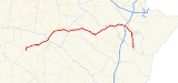
State Route 144 is an east–west highway in southern Georgia
, USA. It begins near the Atlantic coast southeast of Keller
in south Bryan County
, where a spur leads to Fort McAllister Historic Park
. From there, it runs west through Fort Stewart
into Liberty County
, then through Long County
, Tattnall County
and finally into Appling County
, where it terminates just north of Baxley
at its intersection with U.S. 1. Along its route S.R. 144 passes through or near the communities of Richmond Hill
, Hinesville
, and Glennville
. It intersects with I-95
in Richmond Hill and U.S. Highway 301
in Glennville.
Georgia (U.S. state)
Georgia is a state located in the southeastern United States. It was established in 1732, the last of the original Thirteen Colonies. The state is named after King George II of Great Britain. Georgia was the fourth state to ratify the United States Constitution, on January 2, 1788...
, USA. It begins near the Atlantic coast southeast of Keller
Keller, Georgia
Keller is a small unincorporated community located in southern Bryan County, Georgia, United States, east of Richmond Hill. Its boundaries are ill-defined, but the community could be said to be centered on the intersection of S.R. 144 and Belfast-Keller Road. Currently the area, like all of South...
in south Bryan County
Bryan County, Georgia
Bryan County is a county located in the U.S. state of Georgia. As of 2000, the population was 23,417. The 2007 Census Estimate shows a population of 30,132...
, where a spur leads to Fort McAllister Historic Park
Fort McAllister Historic Park
Fort McAllister Historic Park is a Georgia state park located near Keller and Richmond Hill in South Bryan County, Georgia and on the south bank of the Ogeechee River . The park is home to the best preserved earthwork fortification of the Confederacy...
. From there, it runs west through Fort Stewart
Fort Stewart
Fort Stewart is a census-designated place and U.S. Army post primarily in Liberty County and Bryan County, but also extending into smaller portions of Evans, Long, and Tattnall Counties in Georgia, USA. The population was 11,205 at the 2000 census...
into Liberty County
Liberty County, Georgia
Liberty County is a county located in the U.S. state of Georgia. As of 2000, the population was 61,610. The 2007 Census Estimate shows a population of 60,503...
, then through Long County
Long County, Georgia
Long County is a county located in the U.S. state of Georgia. The constitutional amendment to create the county was proposed August 14, 1920, and ratified November 2, 1920. As of 2000, the population is 10,304. The 2007 Census Estimate shows a population of 11,300...
, Tattnall County
Tattnall County, Georgia
Tattnall County is a county located in the U.S. state of Georgia. As of 2000, the population was 22,305. The 2007 Census Estimate showed a population of 23,179...
and finally into Appling County
Appling County, Georgia
Appling County is a county located in the U.S. state of Georgia. As of 2000, the population is 17,419. The 2007 Census Estimate placed the population at 17,946...
, where it terminates just north of Baxley
Baxley, Georgia
As of the census of 2000, there were 4,150 people, 1,567 households, and 1,048 families residing in the city. The population density was 580.7 people per square mile . There were 1,866 housing units at an average density of 261.1 per square mile...
at its intersection with U.S. 1. Along its route S.R. 144 passes through or near the communities of Richmond Hill
Richmond Hill, Georgia
Richmond Hill is a city in Bryan County, Georgia, United States. The population was 6,959 at the 2000 census. It is part of the Savannah Metropolitan Statistical Area.-Geography:Richmond Hill is located at ....
, Hinesville
Hinesville, Georgia
Hinesville is a city in Liberty County, Georgia, United States. The population was 30,392 at the 2000 census. Hinesville is also known to have been the home of three signers of the Declaration of Independence: Lyman Hall, George Walton and Button Gwinnett. The city is the county seat of Liberty...
, and Glennville
Glennville, Georgia
Glennville is a city in Tattnall County, Georgia, United States. The population was 3,641 at the 2000 census.-Geography:Glennville is located at ....
. It intersects with I-95
Interstate 95 in Georgia
Interstate 95, the main Interstate Highway on the east coast of the United States, serves the Atlantic coast of Georgia. It begins at the St. Marys River at the Florida state line north of Jacksonville and heads north past the border of South Carolina at the Savannah River...
in Richmond Hill and U.S. Highway 301
U.S. Route 301
U.S. Route 301 is a spur of U.S. Route 1 running through the South Atlantic States. It currently runs 1,099 miles from Glasgow, Delaware at U.S. Route 40 to Sarasota, Florida. It passes through the states of Delaware, Maryland, Virginia, North Carolina, South Carolina, Georgia, and Florida...
in Glennville.