

Georges River National Park
Encyclopedia
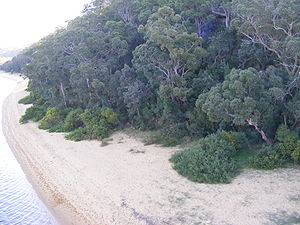
Georges River is a national park in New South Wales
New South Wales
New South Wales is a state of :Australia, located in the east of the country. It is bordered by Queensland, Victoria and South Australia to the north, south and west respectively. To the east, the state is bordered by the Tasman Sea, which forms part of the Pacific Ocean. New South Wales...
(Australia
Australia
Australia , officially the Commonwealth of Australia, is a country in the Southern Hemisphere comprising the mainland of the Australian continent, the island of Tasmania, and numerous smaller islands in the Indian and Pacific Oceans. It is the world's sixth-largest country by total area...
), 18 km southwest of Sydney. It is set along the Georges River
Georges River
The Georges River is a waterway in the state of New South Wales in Australia. It rises to the south-west of Sydney near the coal mining town of Appin, and then flows north past Campbelltown, roughly parallel to the Main South Railway...
, and is run by the National Parks and Wildlife Service
National Parks and Wildlife Service (New South Wales)
The National Parks and Wildlife Service is part of the Office of Environment and Heritage - the main government conservation agency in New South Wales, Australia....
.
The entrance to the reserve is on Henry Lawson Drive
Henry Lawson Drive, Sydney
Henry Lawson Drive is a major 22.9 km sealed road, located in Sydney, New South Wales, which runs from Villawood to Peakhurst.The maximum elevation of the road is 60.9 m AMSL and 1.65 at its lowest point....
, immediately opposite the junction with The River Road, in the City of Bankstown
City of Bankstown
The City of Bankstown is a city and Local Government Area in the Canterbury-Bankstown region of Sydney, New South Wales, Australia, centred on the suburb of Bankstown....
. Henry Lawson Drive is a major arterial road within southern Sydney. You can easily access it from the south side off Alfords Point Drive On the shores of the Georges River, in the Sutherland Shire
Sutherland Shire
The Sutherland Shire is a Local Government Area in the Southern Sydney region of Sydney, Australia. Geographically, it is the area to the south of Botany Bay and the Georges River...
, from the west off the M5 motorway, from the north off Davies Road and from the east off Forest Road.
Fact sheet
- Area: 3.4 km²
- Coordinates: 33°58′58"S 151°01′56"E
- Date of establishment: 24 April 1992
- Managing authorities: National Parks and Wildlife ServiceNational Parks and Wildlife Service (New South Wales)The National Parks and Wildlife Service is part of the Office of Environment and Heritage - the main government conservation agency in New South Wales, Australia....
- IUCNWorld Conservation UnionThe International Union for Conservation of Nature and Natural Resources is an international organization dedicated to finding "pragmatic solutions to our most pressing environment and development challenges." The organization publishes the IUCN Red List, compiling information from a network of...
category: V