
Garland, Utah
Encyclopedia
Garland is a city in Box Elder County
, Utah
, United States
. The population was 2,400 at the 2010 census.
It was a company town
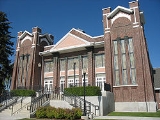
and was renamed after William Garland, the contractor who built the Utah Sugar Company factory at the location, completed in 1903. The company donated land to the LDS Church for a "ward chapel and amusement hall" and also built 14 homes, a hotel, and other buildings. The town had a general store, a bank, a post office, and a newspaper named The Garland Globe in 1906. By 1920s there were other merchants, a flour mill, a Carnegie Library
, and a high school.
, the city has a total area of 1.8 square miles (4.6 km²), all of it land.
of 2000, there were 1,943 people, 588 households, and 476 families residing in the city. The population density
was 1,097.8 people per square mile (423.8/km²). There were 621 housing units at an average density of 350.9 per square mile (135.5/km²). The racial makeup of the city was 88.99% White, 0.41% Native American, 3.14% Asian, 0.05% Pacific Islander, 5.46% from other races
, and 1.96% from two or more races. Hispanic or Latino of any race were 7.87% of the population.
There were 588 households out of which 51.5% had children under the age of 18 living with them, 69.2% were married couples
living together, 7.8% had a female householder with no husband present, and 18.9% were non-families. 17.5% of all households were made up of individuals and 8.5% had someone living alone who was 65 years of age or older. The average household size was 3.30 and the average family size was 3.74.
In the city the population was spread out with 39.6% under the age of 18, 10.4% from 18 to 24, 27.3% from 25 to 44, 14.0% from 45 to 64, and 8.6% who were 65 years of age or older. The median age was 25 years. For every 100 females there were 96.5 males. For every 100 females age 18 and over, there were 95.2 males.
The median income for a household in the city was $38,679, and the median income for a family was $42,426. Males had a median income of $35,518 versus $22,237 for females. The per capita income
for the city was $13,408. About 5.7% of families and 6.9% of the population were below the poverty line, including 7.6% of those under age 18 and 4.9% of those age 65 or over.
Box Elder County, Utah
Box Elder County is a county located in the U.S. state of Utah. It lies on the north end of the Great Salt Lake, covering a large area north to the Idaho border and west to the Nevada border. Included in this area are large tracts of barren desert, contrasted by high, forested mountains. The...
, Utah
Utah
Utah is a state in the Western United States. It was the 45th state to join the Union, on January 4, 1896. Approximately 80% of Utah's 2,763,885 people live along the Wasatch Front, centering on Salt Lake City. This leaves vast expanses of the state nearly uninhabited, making the population the...
, United States
United States
The United States of America is a federal constitutional republic comprising fifty states and a federal district...
. The population was 2,400 at the 2010 census.
History
Garland was originally named Sunset and settled in 1890. The first settler was David E. Manning.It was a company town
Company town
A company town is a town or city in which much or all real estate, buildings , utilities, hospitals, small businesses such as grocery stores and gas stations, and other necessities or luxuries of life within its borders are owned by a single company...
and was renamed after William Garland, the contractor who built the Utah Sugar Company factory at the location, completed in 1903. The company donated land to the LDS Church for a "ward chapel and amusement hall" and also built 14 homes, a hotel, and other buildings. The town had a general store, a bank, a post office, and a newspaper named The Garland Globe in 1906. By 1920s there were other merchants, a flour mill, a Carnegie Library
Carnegie Library
Carnegie Library, Carnegie Public Library, Carnegie Free Library, Carnegie Free Public Library, Andrew Carnegie Library, Andrew Carnegie Free Library or Carnegie Library Building may refer to any of the following Carnegie libraries:- California :*Carnegie Library , listed on the National Register...
, and a high school.
Geography
According to the United States Census BureauUnited States Census Bureau
The United States Census Bureau is the government agency that is responsible for the United States Census. It also gathers other national demographic and economic data...
, the city has a total area of 1.8 square miles (4.6 km²), all of it land.
Demographics
As of the censusCensus
A census is the procedure of systematically acquiring and recording information about the members of a given population. It is a regularly occurring and official count of a particular population. The term is used mostly in connection with national population and housing censuses; other common...
of 2000, there were 1,943 people, 588 households, and 476 families residing in the city. The population density
Population density
Population density is a measurement of population per unit area or unit volume. It is frequently applied to living organisms, and particularly to humans...
was 1,097.8 people per square mile (423.8/km²). There were 621 housing units at an average density of 350.9 per square mile (135.5/km²). The racial makeup of the city was 88.99% White, 0.41% Native American, 3.14% Asian, 0.05% Pacific Islander, 5.46% from other races
Race (United States Census)
Race and ethnicity in the United States Census, as defined by the Federal Office of Management and Budget and the United States Census Bureau, are self-identification data items in which residents choose the race or races with which they most closely identify, and indicate whether or not they are...
, and 1.96% from two or more races. Hispanic or Latino of any race were 7.87% of the population.
There were 588 households out of which 51.5% had children under the age of 18 living with them, 69.2% were married couples
Marriage
Marriage is a social union or legal contract between people that creates kinship. It is an institution in which interpersonal relationships, usually intimate and sexual, are acknowledged in a variety of ways, depending on the culture or subculture in which it is found...
living together, 7.8% had a female householder with no husband present, and 18.9% were non-families. 17.5% of all households were made up of individuals and 8.5% had someone living alone who was 65 years of age or older. The average household size was 3.30 and the average family size was 3.74.
In the city the population was spread out with 39.6% under the age of 18, 10.4% from 18 to 24, 27.3% from 25 to 44, 14.0% from 45 to 64, and 8.6% who were 65 years of age or older. The median age was 25 years. For every 100 females there were 96.5 males. For every 100 females age 18 and over, there were 95.2 males.
The median income for a household in the city was $38,679, and the median income for a family was $42,426. Males had a median income of $35,518 versus $22,237 for females. The per capita income
Per capita income
Per capita income or income per person is a measure of mean income within an economic aggregate, such as a country or city. It is calculated by taking a measure of all sources of income in the aggregate and dividing it by the total population...
for the city was $13,408. About 5.7% of families and 6.9% of the population were below the poverty line, including 7.6% of those under age 18 and 4.9% of those age 65 or over.