

Garafía
Encyclopedia
Garafía is a municipality in the Canary Islands
in the province of Santa Cruz de Tenerife
. It is situated on the northern coast of the island of La Palma
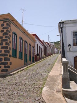
. The capital of the municipality is Santo Domingo. Other villages are Las Tricias, El Castillo, Juan Adalid, Don Pedro, El Tablado, La Mata, San Antonio del Monte and Franceses.
The elevation ranges from 0 at the coast to 2545m at the Roque de los Muchachos
.
Until the 1960s the villages were largely isolated from the rest of the island and only accessible by donkey paths. Since then roads have been built and the area is easily accessible on good, but twisty, asphalted roads.
As with many rural areas the population is in decline as small scale agriculture and traditional rural life does not provide the income to encourage young people to stay.
The majority of the population are rural and a few are urban.
It is however the most wonderful area for walking and hiking with its network of marked walking paths, lush greenery and spectacular scenery. The steep forested hillside are dissected by barrancos (gorges) providing breathtaking views.
It has preserved the rural characteristics and its ecology, that it has a great potential in rural tourism. It is a most stunning place.
The higher parts of Garafia are covered in pine trees with just a small treeless area above the tree line.
The central areas around the villages are mostly farmland or rough natural landscape including almond trees and vineyards
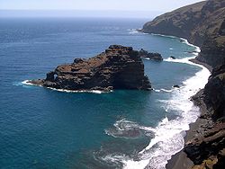
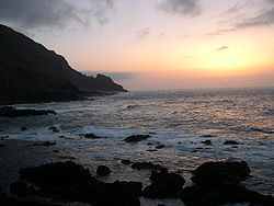
The coastline is rough with steep cliffs and gorges and can be accessed at several points.
At the highest point of the municipality lies Roque de los Muchachos
.
This is the highest point of the island and is on the edge of the Caldera de Taburiente National Park which is the largest erosion crater in the world. The highest point is accessible by asphalted road from both the east and the west side and has several viewing points giving views inside the Caldera and over almost the entire island and often to the neighbouring islands of Tenerife
, La Gomera
and El Hierro
.
Roque de los Muchachos
hosts a famous observatory named the Roque de los Muchachos Observatory
, run by the IAC
and international collaborators.
The postcode is 38787.
The population between 1991 and 2001 fell falling below the 2,000 mark in 1996 but it recovered in the 2002 reached above 2,000 again but plummeted to 1,948 in 2004 and dropped below 2,000 again.
s).
Canary Islands
The Canary Islands , also known as the Canaries , is a Spanish archipelago located just off the northwest coast of mainland Africa, 100 km west of the border between Morocco and the Western Sahara. The Canaries are a Spanish autonomous community and an outermost region of the European Union...
in the province of Santa Cruz de Tenerife
Santa Cruz de Tenerife (province)
Province of Santa Cruz de Tenerife also Province of Santa Cruz is a province of Spain, consisting of the western part of the autonomous community of the Canary Islands. It consists of about half of the Atlantic archipelago, including the islands of Tenerife, La Gomera, El Hierro, and La Palma, and...
. It is situated on the northern coast of the island of La Palma
La Palma
La Palma is the most north-westerly of the Canary Islands. La Palma has an area of 706 km2 making it the fifth largest of the seven main Canary Islands...
. The capital of the municipality is Santo Domingo. Other villages are Las Tricias, El Castillo, Juan Adalid, Don Pedro, El Tablado, La Mata, San Antonio del Monte and Franceses.
The elevation ranges from 0 at the coast to 2545m at the Roque de los Muchachos
Roque de los Muchachos
Roque de los Muchachos is a rocky mound at the highest point on the island of La Palma in the Canary Islands, Spain...
.
Until the 1960s the villages were largely isolated from the rest of the island and only accessible by donkey paths. Since then roads have been built and the area is easily accessible on good, but twisty, asphalted roads.
As with many rural areas the population is in decline as small scale agriculture and traditional rural life does not provide the income to encourage young people to stay.
The majority of the population are rural and a few are urban.
It is however the most wonderful area for walking and hiking with its network of marked walking paths, lush greenery and spectacular scenery. The steep forested hillside are dissected by barrancos (gorges) providing breathtaking views.
It has preserved the rural characteristics and its ecology, that it has a great potential in rural tourism. It is a most stunning place.
The higher parts of Garafia are covered in pine trees with just a small treeless area above the tree line.
The central areas around the villages are mostly farmland or rough natural landscape including almond trees and vineyards
The coastline is rough with steep cliffs and gorges and can be accessed at several points.
At the highest point of the municipality lies Roque de los Muchachos
Roque de los Muchachos
Roque de los Muchachos is a rocky mound at the highest point on the island of La Palma in the Canary Islands, Spain...
.
This is the highest point of the island and is on the edge of the Caldera de Taburiente National Park which is the largest erosion crater in the world. The highest point is accessible by asphalted road from both the east and the west side and has several viewing points giving views inside the Caldera and over almost the entire island and often to the neighbouring islands of Tenerife
Tenerife
Tenerife is the largest and most populous island of the seven Canary Islands, it is also the most populated island of Spain, with a land area of 2,034.38 km² and 906,854 inhabitants, 43% of the total population of the Canary Islands. About five million tourists visit Tenerife each year, the...
, La Gomera
La Gomera
La Gomera is one of Spain's Canary Islands, located in the Atlantic Ocean off the coast of Africa. In area, it is the second-smallest of the seven main islands of this group.- Political organization :...
and El Hierro
El Hierro
El Hierro, nicknamed Isla del Meridiano , is the smallest and farthest south and west of the Canary Islands , in the Atlantic Ocean off the coast of Africa, with a population of 10,162 .- Name :The name El Hierro, although phonetically identical to the Spanish word for 'iron', is generally thought...
.
Roque de los Muchachos
Roque de los Muchachos
Roque de los Muchachos is a rocky mound at the highest point on the island of La Palma in the Canary Islands, Spain...
hosts a famous observatory named the Roque de los Muchachos Observatory
Roque de los Muchachos Observatory
Roque de los Muchachos Observatory is an astronomical observatory located in the municipality of Garafía on the island of La Palma in the Canary Islands...
, run by the IAC
Instituto de Astrofísica de Canarias
The Instituto de Astrofísica de Canarias is an astrophysical research institute located in Tenerife in the Canary Islands, Spain. It was founded in 1975 at the University of La Laguna.It operates two astronomical observatories in the Canary Islands:...
and international collaborators.
The postcode is 38787.
Historical population
| Year | Population | Change | Density |
|---|---|---|---|
| 1991 | 2,013 | - | - |
| 1996 | 2,002 | - | - |
| 2001 | 1,795 | - | 17.42/km² |
| 2002 | 2,002 | - | - |
| 2003 | 1,998 | - | 119.35/km² |
| 2004 | 1,948 | - | 18.78/km² |
The population between 1991 and 2001 fell falling below the 2,000 mark in 1996 but it recovered in the 2002 reached above 2,000 again but plummeted to 1,948 in 2004 and dropped below 2,000 again.
Other
Garafía has a few schools, a few lyceums, a gymnasium, churches, a small beach, a small port, a post office and a few squares (plazaPlaza
Plaza is a Spanish word related to "field" which describes an open urban public space, such as a city square. All through Spanish America, the plaza mayor of each center of administration held three closely related institutions: the cathedral, the cabildo or administrative center, which might be...
s).
External links
- Map and aerial photos
- Street map: Street map from Mapquest, MapPoint or Google
- Satellite images: Google
 |
 |
 |