

Galloway Road (Miami)
Encyclopedia
Miami-Dade County, Florida
Miami-Dade County is a county located in the southeastern part of the state of Florida. As of 2010 U.S. Census, the county had a population of 2,496,435, making it the most populous county in Florida and the eighth-most populous county in the United States...
Miami, Florida
Florida
Florida is a state in the southeastern United States, located on the nation's Atlantic and Gulf coasts. It is bordered to the west by the Gulf of Mexico, to the north by Alabama and Georgia and to the east by the Atlantic Ocean. With a population of 18,801,310 as measured by the 2010 census, it...
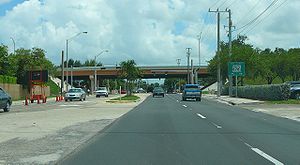
. It exists in several non-contiguous stretches from south Miami-Dade to Miami Lakes.
Route description
The southern terminus is a dead-end near Black Creek Marina, between Black Creek Canal and Biscayne National ParkBiscayne National Park
Biscayne National Park is a U.S. National Park located in southern Florida, due east of Homestead. The park preserves Biscayne Bay, one of the top scuba diving areas in the United States. Ninety-five percent of the park is water. In addition, the shore of the bay is the location of an extensive...
at Biscayne Bay
Biscayne Bay
Biscayne Bay is a lagoon that is approximately 35 miles long and up to 8 miles wide located on the Atlantic coast of South Florida, United States. It is usually divided for purposes of discussion and analysis into three parts: North Bay, Central Bay, and South Bay. Its area is...
just south of the town of Cutler Bay
Cutler Bay, Florida
Cutler Bay, historically called Cutler Ridge, is an incorporated town in Miami-Dade County, Florida from SW 184th Street east of US-1 to the coast, and north of Black Point Marina, at...
. It is a two-lane road until North Kendall Drive. After crossing South 232 Street it enters the town of Cutler Bay. It continues north through Cutler Bay until it crosses Eureka Drive and enters into the village of Palmetto Bay
Palmetto Bay, Florida
Palmetto Bay is a Miami suburban incorporated village in Miami-Dade County, Florida, United States. The population was 24,469 at the 2000 census.Palmetto Bay includes two census-designated places defined in the 2000 census, Cutler and East Perrine.-History:...
where it continues north until it becomes Colonial Drive (South 164th Street) near Canal C-100.
It continues north from South 163rd Terrace on the other side of Canal C-100 through Palmetto Bay until it dead-ends at Canal C-100-C near U.S. 1
U.S. Route 1 in Florida
U.S. Route 1 in Florida runs along the state's east coast from Key West to its crossing of the St. Marys River into Georgia north of Boulogne, and south of Folkston. US 1 was designated through Florida when the U.S. Highway System was established in 1926.US 1 runs in the state of Florida, and...
(South Dixie Highway) a block north of South 141st Street.
It continues north from South 134th Street in unincorporated Miami-Dade County and at this point it is also known as State Road 973
State Road 973 (Florida)
State Road 973, locally known as Galloway Road and Southwest or Northwest 87th Avenue, is a long north–south street connecting U.S. Route 1 in Pinecrest with the Dolphin Expressway in Doral...
. It is a four-lane roadway for a small section from South 132nd Street to South 128th Street and then it is a two-lane roadway again until it crosses North Kendall Drive (South 88th Street) where it widens to four lanes. At Flagler Street, it expands to six lanes.
As the road enters the city of Doral
Doral, Florida
Doral is a city located in north-central Miami-Dade County, Florida, United States. A suburb of Miami, it lies north-west of Miami International Airport. It takes its name from the famous golf and spa resort located within its municipal boundaries. The Doral Golf Resort & Spa was originally built...
north of the Dolphin Expressway (SR 836)), it is no longer State Road 973. North of North 36 Street (Florida State Road 948), Galloway narrows down to four lanes as it passes the Doral Golf Resort and Spa. It continues north through the city of Doral until it crosses North 58th Street, where it divides the city of Doral to the west with unincorporated Miami-Dade County to the east.
It continues north of 58th as a two-lane roadway through industrial areas, and north of North 72 Street it becomes a dirt road. It continues as a dirt road until it ends north of its intersection of North 74 Street (also dirt). North of this, West 87 Avenue resumes as a short side street in an industrial part of Medley between North 95 Street and South River Drive.
Two far-northern, discontiguous stretches of this roadway also exist. The first picks up at the Okeechobee Service Road (which parallels Okeechobee Road / US 27) in Hialeah Gardens, and continues north into Hialeah, where it picks up the additional designation of West 28th Avenue during its run through that city. This stretch ends at Miami Lakes Drive (North 154 Street), and is mostly four lanes. The final stretch picks up again in a residential neighborhood near North 162 Street, and continues north, mainly as a 2 lane residential street until it reaches Miami Gardens Drive (North 186 Street). North of there it is a four-lane roadway until it ends at North 197 Terrace in Miami Lakes, just short of the Florida Turnpike and the Broward County line.