

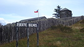
Fuerte Bulnes
Encyclopedia
Chile
Chile ,officially the Republic of Chile , is a country in South America occupying a long, narrow coastal strip between the Andes mountains to the east and the Pacific Ocean to the west. It borders Peru to the north, Bolivia to the northeast, Argentina to the east, and the Drake Passage in the far...
an fort located by the Strait of Magellan
Strait of Magellan
The Strait of Magellan comprises a navigable sea route immediately south of mainland South America and north of Tierra del Fuego...
, 62 km south of Punta Arenas. It was founded in 1843 over a rocky hill at Punta Santa Ana, under the command of President Manuel Bulnes Prieto
Manuel Bulnes
-Sources:* Juan B. Alberdi, Biografia de general Bulnes...
.
The fort's construction was a consequence of the colonization policies in Southern Chile. Chiloé's intendant (governor) Domingo Espiñeira Riesco ordered the construction of a schooner
Schooner
A schooner is a type of sailing vessel characterized by the use of fore-and-aft sails on two or more masts with the forward mast being no taller than the rear masts....
named after the President himself, but its name was changed to "Goleta
Schooner
A schooner is a type of sailing vessel characterized by the use of fore-and-aft sails on two or more masts with the forward mast being no taller than the rear masts....
Ancud
Ancud
Ancud is a city in southern Chile located in the northernmost part of the island and province of Chiloé, in Los Lagos Region .-Geography:...
" by Bulnes in order to reflect the origin of the ship. It sailed from Ancud on May 22, 1843, under the orders of Captain Juan Williams (changed to Chilean version Juan Guillermos, under which name he signed documents), and it arrived at Punta Santa Ana on September 21, 1843, about 2 km from Puerto del Hambre
Puerto Hambre
Puerto Hambre, originally Ciudad del Rey Don Felipe, also known as Puerto del Hambre and at one time as Port Famine, is a historic settlement site at Buena Bay on the west side of the Strait of Magellan approximately south of Punta Arenas in the Región de Magallanes y la Antártica Chilena,...
.
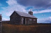
At this place the fort was built, using mainly logs and dirt & grass 'bricks'.
Due to the harsh weather, it was not possible to gather a large and stable population. As a result, after six years of struggling to establish a town in that area, Punta Arenas was founded in the Sandy Point area in 1848. Once people finished moving and settled down in Punta Arenas, the fort was abandoned, and burned by Lieutenant Cambiazo.
Between 1941 and 1943 a reconstruction of the original fort was built complete with the church, chaplain's quarters, jail, powder magazine, post office and stables. It was declared a national monument in 1968. Today, it is administered by CONAF (National Forest Corporation).