

Fajã de Agua
Encyclopedia
{| border="0" cellpadding="2" cellspacing="0" align="right" width="300px" style="font-size: 98%; border: gray solid 1px; border-collapse: collapse;"
|---- bgcolor="#FFFFFF"efefef
| align="center" colspan="2" bgcolor="#d3d3d3"|Fajã de Agua
Fajan di Água
|-----
! align="center" colspan="2" | Statistics
|---- bgcolor="#FFFFFF"
| Island
: || Brava
|---- bgcolor="#FFFFFF"
| Municipality: || Brava
|---- bgcolor="#FFFFFF"
| Distance from the island capital: || west Vila Nova Sintra
{| border="0" cellpadding="2" cellspacing="0" align="right" width="300px" style="font-size: 98%; border: gray solid 1px; border-collapse: collapse;"
|---- bgcolor="#FFFFFF"efefef
| align="center" colspan="2" bgcolor="#d3d3d3"|Fajã de Agua
Fajan di Água
|-----
! align="center" colspan="2" | Statistics
|---- bgcolor="#FFFFFF"
| Island
: || Brava
|---- bgcolor="#FFFFFF"
| Municipality: || Brava
|---- bgcolor="#FFFFFF"
| Distance from the island capital: || west Vila Nova Sintra||
|---- bgcolor="#FFFFFF"
| Area code: || -
|}
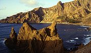 Fajã de Agua (in Cape Verdean Creole, written in ALUPEC
: Fajan di Água), is a village on the northwestern coast of the island of Brava
, Cape Verde
. Fishing and agriculture (maize, beans, bananas and papayas) are the most important sources of income.
was founded.A small airport with a paved runway was inaugurated in Fajã de Água in 1992. It connected Brava with the nearby islands of Fogo
and Santiago
, but was closed because of frequent strong winds which make landing impossible.
|---- bgcolor="#FFFFFF"efefef
| align="center" colspan="2" bgcolor="#d3d3d3"|Fajã de Agua
Fajan di Água
|-----
! align="center" colspan="2" | Statistics
|---- bgcolor="#FFFFFF"
| Island
Island
An island or isle is any piece of sub-continental land that is surrounded by water. Very small islands such as emergent land features on atolls can be called islets, cays or keys. An island in a river or lake may be called an eyot , or holm...
: || Brava
Brava, Cape Verde
Brava is an island in Cape Verde. It is the smallest inhabited island, but at the same time the greenest, of Cape Verde, in the Sotavento group. First settled in the 1540s, its population grew after Mount Fogo on neighbouring Fogo erupted in 1675...
|---- bgcolor="#FFFFFF"
| Municipality: || Brava
Brava, Cape Verde
Brava is an island in Cape Verde. It is the smallest inhabited island, but at the same time the greenest, of Cape Verde, in the Sotavento group. First settled in the 1540s, its population grew after Mount Fogo on neighbouring Fogo erupted in 1675...
|---- bgcolor="#FFFFFF"
| Distance from the island capital: || west Vila Nova Sintra
{| border="0" cellpadding="2" cellspacing="0" align="right" width="300px" style="font-size: 98%; border: gray solid 1px; border-collapse: collapse;"
|---- bgcolor="#FFFFFF"efefef
| align="center" colspan="2" bgcolor="#d3d3d3"|Fajã de Agua
Fajan di Água
|-----
! align="center" colspan="2" | Statistics
|---- bgcolor="#FFFFFF"
| Island
Island
An island or isle is any piece of sub-continental land that is surrounded by water. Very small islands such as emergent land features on atolls can be called islets, cays or keys. An island in a river or lake may be called an eyot , or holm...
: || Brava
Brava, Cape Verde
Brava is an island in Cape Verde. It is the smallest inhabited island, but at the same time the greenest, of Cape Verde, in the Sotavento group. First settled in the 1540s, its population grew after Mount Fogo on neighbouring Fogo erupted in 1675...
|---- bgcolor="#FFFFFF"
| Municipality: || Brava
Brava, Cape Verde
Brava is an island in Cape Verde. It is the smallest inhabited island, but at the same time the greenest, of Cape Verde, in the Sotavento group. First settled in the 1540s, its population grew after Mount Fogo on neighbouring Fogo erupted in 1675...
|---- bgcolor="#FFFFFF"
| Distance from the island capital: || west Vila Nova Sintra||
|---- bgcolor="#FFFFFF"
| Area code: || -
|}
ALUPEC
The Alfabeto Unificado para a Escrita do Caboverdiano , commonly known as ALUPEC, is the alphabet that was officially recognized by the Cape Verdean government to write Cape Verdean Creole.- Description :...
: Fajan di Água), is a village on the northwestern coast of the island of Brava
Brava, Cape Verde
Brava is an island in Cape Verde. It is the smallest inhabited island, but at the same time the greenest, of Cape Verde, in the Sotavento group. First settled in the 1540s, its population grew after Mount Fogo on neighbouring Fogo erupted in 1675...
, Cape Verde
Cape Verde
The Republic of Cape Verde is an island country, spanning an archipelago of 10 islands located in the central Atlantic Ocean, 570 kilometres off the coast of Western Africa...
. Fishing and agriculture (maize, beans, bananas and papayas) are the most important sources of income.
History
In the 18th and 19th century, whaling was an important source of income for Brava. Many whaling ships from America landed in Fajã de Água. Fajã de Água used to be the most important harbour of Brava until 1843 when the present harbour of FurnaFurna
Furna is a municipality in the district of Prättigau/Davos in the Swiss canton of Graubünden.-Demographics:Furna has a population of . , 0.5% of the population was made up of foreign nationals. Over the last 10 years the population has grown at a rate of 0.5%...
was founded.A small airport with a paved runway was inaugurated in Fajã de Água in 1992. It connected Brava with the nearby islands of Fogo
Fogo, Cape Verde
Fogo is an island in the Sotavento group of Cape Verde. It is the most prominent of the group, rising to nearly 3,000 m above sea level at Pico do Fogo.-Geography:...
and Santiago
Santiago, Cape Verde
Santiago , or Santiagu in Cape Verdean Creole, is the largest island of Cape Verde, its most important agricultural centre and home to half the nation’s population. At the time of Darwin's voyage it was called St. Jago....
, but was closed because of frequent strong winds which make landing impossible.