
Extreme points of Northern Cyprus
Encyclopedia
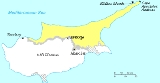
Cyprus
Cyprus , officially the Republic of Cyprus , is a Eurasian island country, member of the European Union, in the Eastern Mediterranean, east of Greece, south of Turkey, west of Syria and north of Egypt. It is the third largest island in the Mediterranean Sea.The earliest known human activity on the...
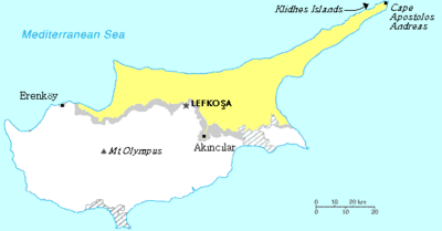
. From the grid below, it can be observed that the most easterly and northerly places are the same, due to the north-easterly protrusion of the Karpass Peninsula
Karpass Peninsula
The Karpass Peninsula , also known as Karpasia or Kırpaşa is a long, finger-like peninsula that is one of the most prominent geographical features of the island of Cyprus. Its farthest extent is Cape Apostolos Andreas, and its major population centre is the town of Rizokarpaso...
.
| Direction | Location | District | Coordinates |
|---|---|---|---|
| North | Klidhes Islands | İskele | 35°43′N 34°36′E |
| North (mainland) | Cape Apostolos Andreas Cape Apostolos Andreas Cape Apostolos Andreas is the north-easternmost point of the Mediterranean island of Cyprus . It lies at the tip of the finger-like Karpass Peninsula.The famous Apostolos Andreas Monastery is located just south of the promontory itself.... |
İskele | 35°41.70′N 34°35.20′E |
| South | Akıncılar | Lefkosia (Nicosia) Nicosia District For the district of Northern Cyprus, see Lefkoşa District.Nicosia District is one of the six districts of Cyprus. Its main town is the island country's capital city, Nicosia... |
35°00′50.00"N 33°27′48.43"E |
| East | Klidhes Islands | İskele | 35°43′N 34°36′E |
| East (mainland) | Cape Apostolos Andreas Cape Apostolos Andreas Cape Apostolos Andreas is the north-easternmost point of the Mediterranean island of Cyprus . It lies at the tip of the finger-like Karpass Peninsula.The famous Apostolos Andreas Monastery is located just south of the promontory itself.... |
İskele | 35°41.70′N 34°35.20′E |
| West | Erenköy Kokkina exclave Kokkina is an exclave of the internationally unrecognised Turkish Republic of Northern Cyprus. It was one of the Turkish Cypriot enclaves prior to the Turkish invasion of Cyprus in 1974. It is hemmed in on three sides by mountainous territory controlled by the Republic of Cyprus with the... , in the Kokkina exclave |
Kokkina exclave Kokkina exclave Kokkina is an exclave of the internationally unrecognised Turkish Republic of Northern Cyprus. It was one of the Turkish Cypriot enclaves prior to the Turkish invasion of Cyprus in 1974. It is hemmed in on three sides by mountainous territory controlled by the Republic of Cyprus with the... |
35°10′36.48"N 32°38′12.84"E |
| Description | Location | Height above sea-level (m) | Area Description | Coordinates |
|---|---|---|---|---|
| Highest Point | Mount Selvili | 1,023m (3,357 ft) | Part of the Kyrenia Range, which is a limestone ridge along the mid-northern coast of Cyprus. | 35°19′13"N 33°09′31"E |
| Lowest Point | Mediterranean Sea Mediterranean Sea The Mediterranean Sea is a sea connected to the Atlantic Ocean surrounded by the Mediterranean region and almost completely enclosed by land: on the north by Anatolia and Europe, on the south by North Africa, and on the east by the Levant... |
0m (0ft) | - | 35°N 18°E |