

Elm Park, Winnipeg
Encyclopedia
Elm Park is a neighbourhood in the city of Winnipeg, Manitoba, Canada
. It is located in the northern section of the district of St. Vital, and is bounded by the Red River
on the north, St. Mary's Road
on the east, Fermor Avenue on the south, and Dunkirk Drive
on the west. As of the 2006 census, Elm Park had a population of 1,710.
 The popularity of Elm Park waned in the 1910s. It closed in approximately 1912 when the pontoon bridge was replaced by a steel truss bridge. Eventually the lands to the east of Dunkirk Drive were bought by the City of St. Vital; the new neighbourhood was named Elm Park after the former park. Although most of the land in the east of the new neighbourhood was converted into single-family housing (with some apartment buildings along St. Mary's Road), most of the land in the southwest corner was converted into the home of the Winnipeg Canoe Club, eventually becoming a private golf course. There are also three small public parks remaining of what was once Elm Park - Dean Finlay Park on the corner of Sunset Boulevard and Killarney Street, Carey Park on Elm Park Road, and St. Vital Memorial Park on Fermor Avenue. Many of the older oak, ash, elm, and cottonwood trees were retained during development and line the streets of the current subdivision.
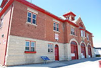
Many buildings in Elm Park were damaged by the 1950 Red River Flood. The neighbourhood was one of the worst hit areas in the city. The St. Vital Fire Hall, which was opened in 1914, sheltered refugees during the flood and was featured in a Life
magazine article about the disaster.
In 1960, the municipality of St. Vital moved into a new City Hall located in Elm Park directly south of the fire hall. The building is still in use as a municipal office for the City of Winnipeg.
Elm Park was protected during the 2009 Red River flood
by both the Red River Floodway
and by the use of sandbags on Kingston Row.
, Windsor School, the South Winnipeg YM/YWCA, and St. Mark's Anglican Church. It is in the federal riding of Saint Boniface
and the provincial riding of St. Vital
.
Canada
Canada is a North American country consisting of ten provinces and three territories. Located in the northern part of the continent, it extends from the Atlantic Ocean in the east to the Pacific Ocean in the west, and northward into the Arctic Ocean...
. It is located in the northern section of the district of St. Vital, and is bounded by the Red River
Red River of the North
The Red River is a North American river. Originating at the confluence of the Bois de Sioux and Otter Tail rivers in the United States, it flows northward through the Red River Valley and forms the border between the U.S. states of Minnesota and North Dakota before continuing into Manitoba, Canada...
on the north, St. Mary's Road
Winnipeg Route 52
Route 52 is a major north-south arterial route in Winnipeg, Manitoba. It comprises all of Main Street from the northern city limits to the Main Street Bridge over the Assiniboine River; Queen Elizabeth Way from the Main Street Bridge to the Norwood Bridge over the Red River; and St. Mary's Road...
on the east, Fermor Avenue on the south, and Dunkirk Drive
Winnipeg Route 62
Route 62 is a major north-south arterial route in Winnipeg, Manitoba that has eight different street names.The official route begins on Salter Street in the city's North End; its northernmost point is often given on maps as the intersection of Salter Street and Redwood Avenue...
on the west. As of the 2006 census, Elm Park had a population of 1,710.
History
The neighbourhoods of Elm Park and Kingston Crescent (located to the west of Dunkirk Drive) were originally a park founded by Albert William Austin's Winnipeg Street Railway Company in 1890. The trolley company had recently extended a line to just north of the Red River along what is now Osborne Street; by founding Elm Park directly across the river from the end of the trolley line, Austin hoped to increase off-peak and weekend use of the line. The trolley company built a pontoon bridge for foot traffic, and Elm Park soon became a popular summertime destination for Winnipeg residents.Many buildings in Elm Park were damaged by the 1950 Red River Flood. The neighbourhood was one of the worst hit areas in the city. The St. Vital Fire Hall, which was opened in 1914, sheltered refugees during the flood and was featured in a Life
Life (magazine)
Life generally refers to three American magazines:*A humor and general interest magazine published from 1883 to 1936. Time founder Henry Luce bought the magazine in 1936 solely so that he could acquire the rights to its name....
magazine article about the disaster.
In 1960, the municipality of St. Vital moved into a new City Hall located in Elm Park directly south of the fire hall. The building is still in use as a municipal office for the City of Winnipeg.
Elm Park was protected during the 2009 Red River flood
2009 Red River flood
The 2009 Red River flood along the Red River of the North in North Dakota and Minnesota in the United States and Manitoba in Canada brought record flood levels to the Fargo-Moorhead area. The flood was a result of saturated and frozen ground, Spring snowmelt exacerbated by additional rain and snow...
by both the Red River Floodway
Red River Floodway
The Red River Floodway is an artificial flood control waterway in Western Canada, first used in 1969. It is a long channel which, during flood periods, takes part of the Red River's flow around the city of Winnipeg, Manitoba to the east and discharges it back into the Red River below the dam at...
and by the use of sandbags on Kingston Row.
Amenities
Elm Park is the home of Glenlawn CollegiateGlenlawn Collegiate
Glenlawn Collegiate is a public English language secondary school in Winnipeg, Manitoba, Canada, located at 770 St. Mary’s Road, Elm Park in the suburb of St. Vital...
, Windsor School, the South Winnipeg YM/YWCA, and St. Mark's Anglican Church. It is in the federal riding of Saint Boniface
Saint Boniface (electoral district)
Saint Boniface is a federal electoral district that has been represented in the Canadian House of Commons since 1925. It is located in Winnipeg, Manitoba, Canada.In 1996, its English name was changed from "St. Boniface" to "Saint Boniface"....
and the provincial riding of St. Vital
St. Vital
St. Vital is a provincial electoral division in the Canadian province of Manitoba.-Historical riding:The original St. Vital riding was established at the time of the province's creation in 1870, as one of twelve "francophone" constituencies...
.