
El Progreso
Encyclopedia
The municipality of El Progreso is located in the Honduran
department of Yoro
. Ramón Villeda Morales International Airport
of San Pedro Sula
is located west of the city. To the east of the city is the mountain range of Mico Quemado (Burned Monkey).
El Progreso is located at a crossroads. Due to its strategic location, many travelers or tourists pass through el Progreso in one way or another. For that reason, el Progreso is considered a city of extreme importance in Honduras
. Many travelers going to San Pedro Sula
, Tela
, La Ceiba
, La Lima
, Tegucigalpa
etc. make a connection here, or use it as a rest area.
The territorial extension of the city is 547.5 km². Of this territory; 40.51 km² is defined as urban and 506.99 km² as rural. The city is also divided into three geographic zones, that make up more than 100 barrio
s, that is home to more than 90,000 people. The climate of the city is humid.
Given El Progreso's location as a crossroads several fast food franchises have been established in the city to satisfy the demands of travelers. These companies include Pizza Hut
, Popeye's, Burger King, KFC, Applebees, Wendy's, Baskin Robins, Dunkin' Donuts, and others.
Additionally, a new, modern mall from the Honduran "plaza" chain of shopping centers has been constructed on the outskirts of the city. The mall, named Megaplaza, officially opened in the winter of 2007, and features a large food court with a vast array of Honduran and American fast food companies, several cell phone stores, an arcade, and department stores including Carrion, the largest in Central America. Megaplaza is also home to a new stadium seating-style movie theater screening the latest films from the U.S. and Latin America.
More than 280 km² of this mountain chain are protected by the Honduran Central Government. This is due to its ecological wealth, which is inhabited by a great quantity of plants and exotic animals. The area is also important for the inhabitants of the city because, it is where the water system for the city originates.
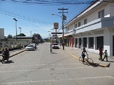
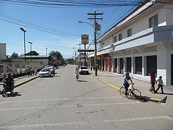
El Progreso is sometimes called "the bicycle City" because many of their people use the bicycle as a faster and more economical mode of transportation. This is perhaps a reflection on the relative poverty among the working class, as many of the city streets remain unpaved, and economic development has remained uneven.
The river runs through the departments of Santa Bárbara
, Cortés
, Yoro
and Atlántida
. It is fed by the rivers: Higuito, Mejocote, Jicatuyo, Pelo river, Comayagua
and Sulaco.
In addition; many other creeks help to its development. The total length of Ulua River is 400 km. Due to its might, Rio Ulúa is also one dangerous river. During cyclones or torrential rains it has a tendency to grow excessively. Therefore, causing damages to the cities where it runs. Hurricane Mitch crept ashore on October 29, 1998 and lingered until November 3, leaving as much as 3 FEET of rain in its wake as it lingered and meandered northward. This resulted in epic flooding and total devastation of the Ulúa basin. Recovery is still incomplete after a decade later.
Honduras
Honduras is a republic in Central America. It was previously known as Spanish Honduras to differentiate it from British Honduras, which became the modern-day state of Belize...
department of Yoro
Yoro (department)
Yoro is one of the 18 departments into which the Central American nation of Honduras is divided.The department contains rich agricultural lands, concentrated mainly on the valley of the Aguan River and the Sula Valley, on opposite ends....
. Ramón Villeda Morales International Airport
Ramón Villeda Morales International Airport
Ramón Villeda Morales International Airport , also known as La Mesa International Airport, is located from the city of San Pedro Sula, in the Cortés Department in Honduras. The airport is named after Ramón Villeda Morales, who served as President of Honduras from 1957 to 1963.It is the major and...
of San Pedro Sula
San Pedro Sula
San Pedro Sula is a city in Honduras. It is located in the northwest corner of the country, in the Valle de Sula , about 60 km south of Puerto Cortés on the Caribbean. With an estimated population of 638,259 people in the main municipality, and 802,598 in its metro area , it is the second...
is located west of the city. To the east of the city is the mountain range of Mico Quemado (Burned Monkey).
El Progreso is located at a crossroads. Due to its strategic location, many travelers or tourists pass through el Progreso in one way or another. For that reason, el Progreso is considered a city of extreme importance in Honduras
Honduras
Honduras is a republic in Central America. It was previously known as Spanish Honduras to differentiate it from British Honduras, which became the modern-day state of Belize...
. Many travelers going to San Pedro Sula
San Pedro Sula
San Pedro Sula is a city in Honduras. It is located in the northwest corner of the country, in the Valle de Sula , about 60 km south of Puerto Cortés on the Caribbean. With an estimated population of 638,259 people in the main municipality, and 802,598 in its metro area , it is the second...
, Tela
Tela
Tela is a town in Honduras on the northern Caribbean coast. It is located in the department of Atlantida.-History:Tela was founded by the Spanish conquistador Cristóbal de Olid on 3 May 1524 near an indigenous town named Tehuacán, ruled by a cacique named Cucumba which had a very good source of...
, La Ceiba
La Ceiba
La Ceiba is a port city on the northern coast of Honduras in Central America. It is located on the southern edge of the Caribbean, forming part of the south eastern boundary of the Gulf of Honduras...
, La Lima
La Lima
La Lima is a municipality in the Honduran department of Cortés. It is home to the corporate headquarters of the Tela Railroad Company, a subsidiary of Chiquita. The city is divided into two halves, La Lima Vieja, located on the western side of the Chamelecon River, and La Lima Nueva, located on...
, Tegucigalpa
Tegucigalpa
Tegucigalpa , and commonly referred as Tegus , is the capital of Honduras and seat of government of the Republic, along with its twin sister Comayagüela. Founded on September 29, 1578 by the Spanish, it became the country's capital on October 30, 1880 under President Marco Aurelio Soto...
etc. make a connection here, or use it as a rest area.
The territorial extension of the city is 547.5 km². Of this territory; 40.51 km² is defined as urban and 506.99 km² as rural. The city is also divided into three geographic zones, that make up more than 100 barrio
Barrio
Barrio is a Spanish word meaning district or neighborhood.-Usage:In its formal usage in English, barrios are generally considered cohesive places, sharing, for example, a church and traditions such as feast days...
s, that is home to more than 90,000 people. The climate of the city is humid.
Economy
Due to its fertile lands, El Progreso is a city of great agricultural tradition. The areas surrounding the city include various plantations producing products such as palm oil, bananas, and vegetables. Besides agriculture, the inhabitants of El Progreso also devote themselves to cattle ranching and to the production and trade of textiles.Given El Progreso's location as a crossroads several fast food franchises have been established in the city to satisfy the demands of travelers. These companies include Pizza Hut
Pizza Hut
Pizza Hut is an American restaurant chain and international franchise that offers different styles of pizza along with side dishes including pasta, buffalo wings, breadsticks, and garlic bread....
, Popeye's, Burger King, KFC, Applebees, Wendy's, Baskin Robins, Dunkin' Donuts, and others.
Additionally, a new, modern mall from the Honduran "plaza" chain of shopping centers has been constructed on the outskirts of the city. The mall, named Megaplaza, officially opened in the winter of 2007, and features a large food court with a vast array of Honduran and American fast food companies, several cell phone stores, an arcade, and department stores including Carrion, the largest in Central America. Megaplaza is also home to a new stadium seating-style movie theater screening the latest films from the U.S. and Latin America.
Mico Quemado
The Mountain chain of Mico Quemado is one of the main attractions of the city. It is located to the east of el Progreso, facing the great Valley of Sula.More than 280 km² of this mountain chain are protected by the Honduran Central Government. This is due to its ecological wealth, which is inhabited by a great quantity of plants and exotic animals. The area is also important for the inhabitants of the city because, it is where the water system for the city originates.
El Progreso is sometimes called "the bicycle City" because many of their people use the bicycle as a faster and more economical mode of transportation. This is perhaps a reflection on the relative poverty among the working class, as many of the city streets remain unpaved, and economic development has remained uneven.
Ulua River
The River Ulúa is one of the biggest and most important rivers of Honduras. This river has its birth in the department of Intibucá under the name of Rio Grande de Otoro.The river runs through the departments of Santa Bárbara
Santa Bárbara (department)
Santa Bárbara is one of the 18 departments into which the Central American nation of Honduras is divided.The departmental capital is Santa Bárbara.The department covers a total surface area of 5,115...
, Cortés
Cortés (department)
Cortés is one of the 18 departments into which the Central American nation of Honduras is divided. The department covers a total surface area of 3,954 km² and, in 2005, had an estimated population of 1,365,497 people, making it the most populous department in Honduras...
, Yoro
Yoro (department)
Yoro is one of the 18 departments into which the Central American nation of Honduras is divided.The department contains rich agricultural lands, concentrated mainly on the valley of the Aguan River and the Sula Valley, on opposite ends....
and Atlántida
Atlántida (department)
Atlántida is a department located on the north Caribbean shore of Honduras, Central America. The capital is the port city of La Ceiba.In the past decades the tourism took over to become the most important legitimate economic source for the coastal area. In 2005 it had an estimated population of...
. It is fed by the rivers: Higuito, Mejocote, Jicatuyo, Pelo river, Comayagua
Comayagua
Comayagua is a city in Honduras, some 80 km northwest of Tegucigalpa on the highway to San Pedro Sula at an elevation of 594 meters above sea level. In 2003 the estimated population was 60,000 people. It is the capital of the Comayagua department of Honduras. The city is noted for its wealth...
and Sulaco.
In addition; many other creeks help to its development. The total length of Ulua River is 400 km. Due to its might, Rio Ulúa is also one dangerous river. During cyclones or torrential rains it has a tendency to grow excessively. Therefore, causing damages to the cities where it runs. Hurricane Mitch crept ashore on October 29, 1998 and lingered until November 3, leaving as much as 3 FEET of rain in its wake as it lingered and meandered northward. This resulted in epic flooding and total devastation of the Ulúa basin. Recovery is still incomplete after a decade later.