
Dunreith, Indiana
Encyclopedia
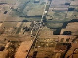
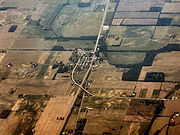
Dunreith is a town in Spiceland Township
, Henry County
, Indiana
, United States
. The population was 177 at the 2010 census.
According to the United States Census Bureau
, the town has a total area of 0.1 square mile (0.258998811 km²), all of it land.
of 2000, there were 184 people, 75 households, and 62 families residing in the town. The population density
was 1,316.7 people per square mile (507.4/km²). There were 78 housing units at an average density of 558.2 per square mile (215.1/km²). The racial makeup of the town was 100.00% White. Hispanic or Latino of any race were 1.09% of the population.
 There were 75 households out of which 28.0% had children under the age of 18 living with them, 64.0% were married couples
living together, 10.7% had a female householder with no husband present, and 17.3% were non-families. 17.3% of all households were made up of individuals and 12.0% had someone living alone who was 65 years of age or older. The average household size was 2.45 and the average family size was 2.68.
In the town the population was spread out with 17.9% under the age of 18, 9.2% from 18 to 24, 28.3% from 25 to 44, 26.6% from 45 to 64, and 17.9% who were 65 years of age or older. The median age was 42 years. For every 100 females there were 104.4 males. For every 100 females age 18 and over, there were 101.3 males.
The median income for a household in the town was $39,250, and the median income for a family was $44,688. Males had a median income of $40,781 versus $25,357 for females. The per capita income
for the town was $20,697. About 1.8% of families and 4.7% of the population were below the poverty line, including none of those under the age of eighteen and 12.5% of those sixty five or over.
Spiceland Township, Henry County, Indiana
Spiceland Township is one of thirteen townships in Henry County, Indiana, USA. As of the 2000 census, its population was 2,200.-Geography:Spiceland Township covers an area of ; of this, or 0.22 percent is water.-Unincorporated towns:* Ogden...
, Henry County
Henry County, Indiana
As of the census of 2000, there were 48,508 people, 19,486 households, and 13,971 families residing in the county. The population density was 124 people per square mile . There were 20,592 housing units at an average density of 52 per square mile...
, Indiana
Indiana
Indiana is a US state, admitted to the United States as the 19th on December 11, 1816. It is located in the Midwestern United States and Great Lakes Region. With 6,483,802 residents, the state is ranked 15th in population and 16th in population density. Indiana is ranked 38th in land area and is...
, United States
United States
The United States of America is a federal constitutional republic comprising fifty states and a federal district...
. The population was 177 at the 2010 census.
Geography
Dunreith is located at 39°48′11"N 85°26′13"W (39.802940, -85.436849).According to the United States Census Bureau
United States Census Bureau
The United States Census Bureau is the government agency that is responsible for the United States Census. It also gathers other national demographic and economic data...
, the town has a total area of 0.1 square mile (0.258998811 km²), all of it land.
Demographics
As of the censusCensus
A census is the procedure of systematically acquiring and recording information about the members of a given population. It is a regularly occurring and official count of a particular population. The term is used mostly in connection with national population and housing censuses; other common...
of 2000, there were 184 people, 75 households, and 62 families residing in the town. The population density
Population density
Population density is a measurement of population per unit area or unit volume. It is frequently applied to living organisms, and particularly to humans...
was 1,316.7 people per square mile (507.4/km²). There were 78 housing units at an average density of 558.2 per square mile (215.1/km²). The racial makeup of the town was 100.00% White. Hispanic or Latino of any race were 1.09% of the population.
Marriage
Marriage is a social union or legal contract between people that creates kinship. It is an institution in which interpersonal relationships, usually intimate and sexual, are acknowledged in a variety of ways, depending on the culture or subculture in which it is found...
living together, 10.7% had a female householder with no husband present, and 17.3% were non-families. 17.3% of all households were made up of individuals and 12.0% had someone living alone who was 65 years of age or older. The average household size was 2.45 and the average family size was 2.68.
In the town the population was spread out with 17.9% under the age of 18, 9.2% from 18 to 24, 28.3% from 25 to 44, 26.6% from 45 to 64, and 17.9% who were 65 years of age or older. The median age was 42 years. For every 100 females there were 104.4 males. For every 100 females age 18 and over, there were 101.3 males.
The median income for a household in the town was $39,250, and the median income for a family was $44,688. Males had a median income of $40,781 versus $25,357 for females. The per capita income
Per capita income
Per capita income or income per person is a measure of mean income within an economic aggregate, such as a country or city. It is calculated by taking a measure of all sources of income in the aggregate and dividing it by the total population...
for the town was $20,697. About 1.8% of families and 4.7% of the population were below the poverty line, including none of those under the age of eighteen and 12.5% of those sixty five or over.