

Dix, Illinois
Encyclopedia
Jefferson County, Illinois
Jefferson County is a county located in the southern part of the U.S. state of Illinois. According to the 2010 census, it has a population of 38,827, which is a decrease of 3.0% from 40,045 in 2000...
, Illinois
Illinois
Illinois is the fifth-most populous state of the United States of America, and is often noted for being a microcosm of the entire country. With Chicago in the northeast, small industrial cities and great agricultural productivity in central and northern Illinois, and natural resources like coal,...
, United States
United States
The United States of America is a federal constitutional republic comprising fifty states and a federal district...
. The population was 494 at the 2000 census. It is part of the Mount Vernon
Mount Vernon, Illinois
Mount Vernon is a city located near the center of Jefferson County, Illinois, in the United States. In the 2010 census, the city's reported population was 15,277 people....
Micropolitan Statistical Area
Mount Vernon, Illinois micropolitan area
The Mount Vernon Micropolitan Statistical Area, as defined by the United States Census Bureau, is an area consisting of two counties in southern Illinois, anchored by the city of Mount Vernon....
.
Geography
Dix is located at 38°26′26"N 88°56′33"W (38.440676, -88.942463).According to the United States Census Bureau
United States Census Bureau
The United States Census Bureau is the government agency that is responsible for the United States Census. It also gathers other national demographic and economic data...
, the village has a total area of 2.1 square miles (5.4 km²), of which, 2.1 square miles (5.4 km²) of it is land and 0.48% is water.
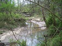
Dix is located on high ground that marks the boundary between the Big Muddy River
Big Muddy River
The Big Muddy River is a river in southern Illinois. It joins the Mississippi River south of Murphysboro. The Big Muddy has been dammed near Benton, forming Rend Lake.The Big Muddy has a mud bottom for most of its length.-Hydrography:...
and its tributary, Casey Creek.
Today Dix is an exit on Interstate 57, a major north/south roadway. When it was founded, however, it was on the Goshen Road, which was the main east/west road in Illinois, running from Old Shawneetown, Illinois
Old Shawneetown, Illinois
Old Shawneetown is a village in Gallatin County, Illinois, United States. As of the 2000 census, the village had a total population of 193. Located along the Ohio River, Shawneetown served as an important United States government administrative center for the Northwest Territory. The village was...
to near East St. Louis, Illinois
East St. Louis, Illinois
East St. Louis is a city located in St. Clair County, Illinois, USA, directly across the Mississippi River from St. Louis, Missouri in the Metro-East region of Southern Illinois. As of the 2010 census, the city had a total population of 27,006, less than one-third of its peak of 82,366 in 1950...
.
History
Among the first settlers around Dix were two brothers named Andrews or Anderson, who came from Rome, New YorkRome, New York
Rome is a city in Oneida County, New York, United States. It is located in north-central or "upstate" New York. The population was 44,797 at the 2010 census. It is in New York's 24th congressional district. In 1758, British forces began construction of Fort Stanwix at this strategic location, but...
, in 1830. One of them established a post office called "Jordan's Prairie", the name already given to the grassland to the south. Later he platted out a village, which he called "Rome", after his home town. The post office was moved into the village in 1852, and the name changed.
Hiram Milburn of Kell, Illinois
Kell, Illinois
Kell is a village in Marion County, Illinois, United States. The population was 231 at the 2000 census.-Geography:Kell is located at .According to the United States Census Bureau, the village has a total area of , all of it land....
moved to Rome between 1853 and 1855. Milburn built a storehouse in 1853 and a hotel in 1854. It is said that, during the construction of the hotel, a wind blew the structure down into a pile, while two men were on the joists, but nobody was hurt. In 1855 Milburn purchased Lewty's Mill and moved it to Rome.
Although Rome Township still exists, the name of the town was changed to "Dix" when the village was incorporated in 1869. There was and still is another Rome, Illinois
Rome, Illinois
Rome is an unincorporated census-designated place in Peoria County, Illinois, United States. The population of the CDP was 1,738 at the 2010 census. Rome is part of the Peoria, Illinois Metropolitan Statistical Area...
and the Post Office insisted that the name of this village be changed.
There are several stories as to the origin of the name "Dix". One is that the town was renamed in honor of Gen. John Adams Dix
John Adams Dix
John Adams Dix was an American politician from New York. He served as Secretary of the Treasury, U.S. Senator, and the 24th Governor of New York. He was also a Union major general during the Civil War.-Early life and career:...
. At the outbreak of the Civil War, Gen. Dix sent a telegram to his agents in New Orleans stating: "If any man pulls down the American flag, shoot him on the spot". Although the telegram was intercepted by Confederate agents and never reached its intended recipient, the text reached the press, and Gen. Dix became one of the first heroes in the North.
Dix is served by the Norfolk Southern Railway
Norfolk Southern Railway
The Norfolk Southern Railway is a Class I railroad in the United States, owned by the Norfolk Southern Corporation. With headquarters in Norfolk, Virginia, the company operates 21,500 route miles in 22 eastern states, the District of Columbia and the province of Ontario, Canada...
. This was built around 1890. The rail line comes from the St. Louis area and turns southeast at Dix. It follows the west side of Casey Creek down to Mt. Vernon.
Demographics
As of the censusCensus
A census is the procedure of systematically acquiring and recording information about the members of a given population. It is a regularly occurring and official count of a particular population. The term is used mostly in connection with national population and housing censuses; other common...
of 2000, there were 494 people, 274 households, and 116 families residing in the village. The population density
Population density
Population density is a measurement of population per unit area or unit volume. It is frequently applied to living organisms, and particularly to humans...
was 235.9 people per square mile (91.3/km²). There were 287 housing units at an average density of 137.0 per square mile (53.0/km²). The racial makeup of the village was 98.38% White, 0.20% African American, 0.81% Asian, 0.20% from other races
Race (United States Census)
Race and ethnicity in the United States Census, as defined by the Federal Office of Management and Budget and the United States Census Bureau, are self-identification data items in which residents choose the race or races with which they most closely identify, and indicate whether or not they are...
, and 0.40% from two or more races. Hispanic or Latino of any race were 0.40% of the population.
There were 274 households out of which 16.8% had children under the age of 18 living with them, 34.3% were married couples
Marriage
Marriage is a social union or legal contract between people that creates kinship. It is an institution in which interpersonal relationships, usually intimate and sexual, are acknowledged in a variety of ways, depending on the culture or subculture in which it is found...
living together, 6.2% had a female householder with no husband present, and 57.3% were non-families. 54.7% of all households were made up of individuals and 36.1% had someone living alone who was 65 years of age or older. The average household size was 1.80 and the average family size was 2.73.
In the village the population was spread out with 18.4% under the age of 18, 4.9% from 18 to 24, 20.4% from 25 to 44, 24.1% from 45 to 64, and 32.2% who were 65 years of age or older. The median age was 50 years. For every 100 females there were 77.7 males. For every 100 females age 18 and over, there were 69.3 males.
The median income for a household in the village was $12,222, and the median income for a family was $37,321. Males had a median income of $28,000 versus $19,306 for females. The per capita income
Per capita income
Per capita income or income per person is a measure of mean income within an economic aggregate, such as a country or city. It is calculated by taking a measure of all sources of income in the aggregate and dividing it by the total population...
for the village was $12,463. About 10.6% of families and 22.0% of the population were below the poverty line, including 9.7% of those under age 18 and 29.5% of those age 65 or over.