

Divisópolis
Encyclopedia
Minas Gerais
Minas Gerais is one of the 26 states of Brazil, of which it is the second most populous, the third richest, and the fourth largest in area. Minas Gerais is the Brazilian state with the largest number of Presidents of Brazil, the current one, Dilma Rousseff, being one of them. The capital is the...
.
The population as of 2007 was estimated to be 7,852 people living in a total area of 566 km². The city belongs to the mesoregion of Jequitinhonha and to the microregion of Almenara
Almenara, Minas Gerais
Almenara is a city in the northeast of the Brazilian state of Minas Gerais. Situated on the Jequitinhonha River it is the largest town in that river valley. Its 2007 population was estimated at 36,907 and the municipal area was 2,301 km²....
.
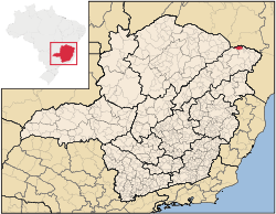
Divisópolis is located on the state boundary of Minas Gerais
Minas Gerais
Minas Gerais is one of the 26 states of Brazil, of which it is the second most populous, the third richest, and the fourth largest in area. Minas Gerais is the Brazilian state with the largest number of Presidents of Brazil, the current one, Dilma Rousseff, being one of them. The capital is the...
and Bahia
Bahia
Bahia is one of the 26 states of Brazil, and is located in the northeastern part of the country on the Atlantic coast. It is the fourth most populous Brazilian state after São Paulo, Minas Gerais and Rio de Janeiro, and the fifth-largest in size...
. It is 26 km. south of the Bahian city of Encruzilhada
Encruzilhada
Encruzilhada is a town and municipality in the state of Bahia in the North-East region of Brazil.-References:...
. Highway connections are poor making the region isolated and impoverished. The distance to the state capital Belo Horizonte
Belo Horizonte
Belo Horizonte is the capital of and largest city in the state of Minas Gerais, located in the southeastern region of Brazil. It is the third largest metropolitan area in the country...
is 551 km.
Neighboring municipalites are: Pedra Azul
Pedra Azul
Pedra Azul is a Brazilian city in the state of Minas Gerais, located in the northeast of the state, in the Jequitinhonha River valley region. The population in 2007 was 24,851 in a total area of 1,619 km²....
, Almenara
Almenara, Minas Gerais
Almenara is a city in the northeast of the Brazilian state of Minas Gerais. Situated on the Jequitinhonha River it is the largest town in that river valley. Its 2007 population was estimated at 36,907 and the municipal area was 2,301 km²....
, Bandeira
Bandeira, Minas Gerais
Bandeira is a Brazilian municipality located in the state of Minas Gerais. Its population as of 2007 was estimated to be 5,337 people living in a total area of 484 km². The city belongs to the mesoregion of Jequitinhonha and to the microregion of Almenara....
, and Mata Verde
Mata Verde
Mata Verde is a Brazilian municipality located in the state of Minas Gerais. As of 2007 the population was 7,458 and the area was 230.The city belongs to the mesoregion of Jequitinhonha and to the microregion of Almenara. The elevation is 865. It became a municipality in 1993. It is located on...
.
The history of the municipality began with the arrival of the tax collectors Sérgio Chaves and João Antônio Dutra to these lands known as Gerais, in 1936. The region was known as Boca da Mata and, due to the belief that the town had no future, it was called Só se vendo (we have to see), later becoming Sósseveno in 1953. In the same year it became a district of Almenara, separating in 1992.
The location is in a mountainous area with an elevation of 910 meters. The main economic activities are cattle raising and the cultivation of coffee, sugarcane and corn. Coffee is the main crop with 2,650 hectares planted in 2006. The GDP in 2006 was R$24,039,000. There was 01 banking agency as of 2007. In the same year there were 79 automobiles.
This municipality is isolated from major population centers and suffers from drought and poor soils.
- Municipal Human Development IndexHuman Development IndexThe Human Development Index is a composite statistic used to rank countries by level of "human development" and separate "very high human development", "high human development", "medium human development", and "low human development" countries...
: .605 (2000) - State ranking: 825 out of 853 municipalities as of 2000
- National ranking: 4,581 out of 5,138 municipalities as of 2000
- Degree of urbanization: 11.37% (2000)--the rate for Minas Gerais was 82.0%
- Illiteracy rate: 37.57% (15 years old or older) The rate for Minas Gerais was 11.96%; the rate for Brazil was 13.63%
- Urban area covered by sewage system: 1.30%--the rate for Minas Gerais was 81.39%
- Health clinics, health centers, and hospitals: 0, 02, 01 with 18 beds
See also
- List of municipalities in Minas Gerais