

Districts and LLGs of Papua New Guinea
Encyclopedia
| |
|
This page is a list of districts and Local-Level Government areas of Papua New Guinea
.
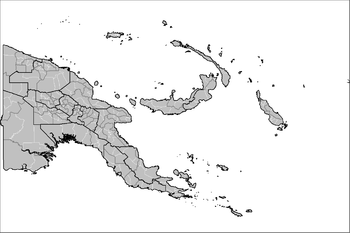
On the highest level, Papua New Guinea is divided into four Regions
. Below, Papua New Guinea has 20 province-level divisions
: 18 integrated provinces, the autonomous province of North Solomons (Bougainville)
and the National Capital District. Each province has one or more districts, and each district has one or more Local Level Government (LLG) areas. For census
purposes, the LLG areas are subdivided into wards and those into census units.
National Capital District
Enga Province
Gulf Province
Madang Province
Morobe Province
Oro (Northern) Province
This page is a list of districts and Local-Level Government areas of Papua New Guinea
Papua New Guinea
Papua New Guinea , officially the Independent State of Papua New Guinea, is a country in Oceania, occupying the eastern half of the island of New Guinea and numerous offshore islands...
.
On the highest level, Papua New Guinea is divided into four Regions
Regions of Papua New Guinea
The four regions of Papua New Guinea are its broadest scale administrative divisions. While the twenty province-level divisions are the primary administrative divisions of the country, the regions are quite significant in daily life, as they are often the basis for organisation of government...
. Below, Papua New Guinea has 20 province-level divisions
Provinces of Papua New Guinea
The provinces of Papua New Guinea are the primary administrative divisions of the country. Provincial governments are branches of the national government– Papua New Guinea is not a federation of provinces...
: 18 integrated provinces, the autonomous province of North Solomons (Bougainville)
Bougainville Province
The Autonomous Region of Bougainville, previously known as North Solomons, is an autonomous region in Papua New Guinea. The largest island is Bougainville Island , and the province also includes the island of Buka and assorted outlying islands including the Carterets...
and the National Capital District. Each province has one or more districts, and each district has one or more Local Level Government (LLG) areas. For census
Census
A census is the procedure of systematically acquiring and recording information about the members of a given population. It is a regularly occurring and official count of a particular population. The term is used mostly in connection with national population and housing censuses; other common...
purposes, the LLG areas are subdivided into wards and those into census units.
National Capital DistrictPort MoresbyPort Moresby , or Pot Mosbi in Tok Pisin, is the capital and largest city of Papua New Guinea . It is located on the shores of the Gulf of Papua, on the southeastern coast of the island of New Guinea, which made it a prime objective for conquest by the Imperial Japanese forces during 1942–43...
| District | District Capital | LLG Name |
|---|---|---|
| National Capital District | Port Moresby Port Moresby Port Moresby , or Pot Mosbi in Tok Pisin, is the capital and largest city of Papua New Guinea . It is located on the shores of the Gulf of Papua, on the southeastern coast of the island of New Guinea, which made it a prime objective for conquest by the Imperial Japanese forces during 1942–43... |
Moresby North-East |
| Moresby North-West | ||
| Moresby South |
 Central ProvinceCentral Province (Papua New Guinea)Central Province is a province in Papua New Guinea located on the southern coast of the country. It has a population of 183,983 people and is in size. The seat of government of Central Province, which is located within the National Capital District outside the province, is the Port Moresby suburb...
| District | District Capital | LLG Name |
|---|---|---|
| Abau District Abau District Abau District is a district of Central Province in Papua New Guinea. It is one of the four administrative districts that make up the province.-Local-level government areas:* Amazon Bay Rural* Aroma Rural* Cloudy Bay Rural-Towns and major villages:... |
Abau | Amazon Bay Rural |
| Aroma Rural | ||
| Cloudy Bay Rural | ||
| Goilala District Goilala District Goilala District is a district of Central Province in Papua New Guinea. It is one of the four administrative districts that make up the province.-Local-level government areas:* Guari Rural* Tapini Rural* Woitape Rural-Towns and major villages:... |
Tapini | Guari Rural Guari Rural LLG The Guari Rural LLG is a local level government area situated in the Goilala District of the Central Province of Papua New Guinea. In 2000, the LLG had 1,148 households, and a population of 5,438... |
| Tapini Rural Tapini Rural LLG The Tapini Rural LLG is a local level government area situated in the Goilala District of the Central Province of Papua New Guinea. In 2000, the LLG had 1,685 households, and a population of 7,315... |
||
| Woitape Rural | ||
| Kairuku-Hiri District Kairuku-Hiri District Kairuku-Hiri District is a district of Central Province in Papua New Guinea. It is one of the four administrative districts that make up the province, and surrounds the national capital, Port Moresby.... |
Bereina Bereina Bereina is a town in the Central Province of Papua New Guinea. It is located on the Hiritano Highway about northwest of Port Moresby, and contains the headquarters of both the Kairuku-Hiri District and the Kairuku Rural local-level government area. Bereina also hosts a regional... |
Hiri Rural |
| Kairuku Rural Kairuku Rural LLG The Kairuku Rural LLG is a local level government area situated in the Kairuku-Hiri District of the Central Province of Papua New Guinea. In 2000, the LLG had 3,485 households, and a population of 19,503 . As of 2007, 3,078 students are enrolled in 20 schools in the LLG... |
||
| Koiari Rural | ||
| Mekeo Kuni Rural | ||
| Rigo District Rigo District Rigo District is a district of Central Province in Papua New Guinea. It is one of the four administrative districts that make up the province.-Local-level government areas:* Rigo Central Rural* Rigo Coastal Rural* Rigo Inland Rural... |
Kwikila | Rigo Central Rural |
| Rigo Coastal Rural | ||
| Rigo Inland Rural |
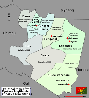
 Eastern Highlands Province
| District | District Capital | LLG Name |
|---|---|---|
| Daulo District Daulo District Daulo District is part of the Eastern Highlands Province in Papua New Guinea. It is along the highway leading to the other Highlands provinces, namely Simbu Province, Western Highlands, Southern Highlands and Enga Province. Daulo is the real home of the famous Asaro Mudman. It has a total... |
Asaro | Asaro-Watabung Rural |
| Goroka District Goroka District Goroka is a district in the Eastern Highlands Province of Papua New Guinea. It contains the city of Goroka.The Dano language is spoken there.... |
Goroka Goroka Goroka is the capital of the Eastern Highlands Province of Papua New Guinea. It is a town of approximately 19,000 people , 1600m above sea level. It has an airport and is on the "Highlands Highway", about 285 km from Lae in Morobe province and 90 km from the nearby town of Kainantu also... |
Goroka Rural |
| Goroka Urban | ||
| Henganofi District Henganofi District Henganofi District is a district of the Eastern Highlands Province in Papua New Guinea. Its capital is Henganofi.... |
Henganofi | Henganofi Rural |
| Kainantu District Kainantu District Kainantu District is a district of the Eastern Highlands Province in Papua New Guinea. Its capital is Kainantu.... |
Kainantu Kainantu Kainantu is a town in the Eastern Highlands of Papua New Guinea. It had some historical significance as an airstrip town during WWII. It functions primarily as a market town for local produce growers and cash croppers. It is located on the "Highlands Highway" approximately 170 km by road from Lae... |
Kainantu Rural |
| Kainantu Urban | ||
| Lufa District Lufa District Lufa District is a district of the Eastern Highlands Province in Papua New Guinea. Its capital is Lufa.... |
Lufa | Lufa Rural |
| Obura-Wonenara District Obura-Wonenara District Obura-Wonenara District is a district of the Eastern Highlands Province in Papua New Guinea. Its capital is Lamari.... |
Lamari | Lamari Rural |
| Yelia Rural | ||
| Okapa District Okapa District Okapa District is a district of the Eastern Highlands Province in Papua New Guinea. Its capital is Okapa.... |
Okapa | Okapa Rural |
| Unggai-Benna District Unggai-Benna District Unggai-Benna District is a district of the Eastern Highlands Province in Papua New Guinea. Its capital is Benna.... |
Benna | Unggai-Benna Rural |
 East New Britain Province
| District | District Capital | LLG Name |
|---|---|---|
| Gazelle District Gazelle District Gazelle District is a district of East New Britain Province in Papua New Guinea. It is one of the four administrative districts that make up the province.-See also:*Districts of Papua New Guinea... |
Kerevat | Central Gazelle Rural |
| Inland Baining Rural | ||
| Lassul Baining Rural | ||
| Livuan-Reimber Rural | ||
| Toma-Vunadidir Rural | ||
| Kokopo District Kokopo District Kokopo District is a district of East New Britain Province in Papua New Guinea. It is one of the four administrative districts that make up the province.-See also:*Districts of Papua New Guinea... |
Kokopo Kokopo Kokopo is the capital of East New Britain in Papua New Guinea. The capital was moved from Rabaul in 1994 when the volcanoes Tavurvur and Vulcan erupted. As a result, the population of the town increased more than sixfold from 3,150 in 1990 to 20,262 in 2000.... |
Bitapaka Rural |
| Duke of York Rural | ||
| Kokopo-Vunamami Urban | ||
| Raluana Rural | ||
| Pomio District Pomio District Pomio District is a district of East New Britain Province in Papua New Guinea. It is one of the four administrative districts that make up the province.-See also:*Districts of Papua New Guinea... |
Pomio | Central-Inland Pomio Rural |
| East Pomio Rural | ||
| Melkoi Rural | ||
| Sinivit Rural | ||
| West Pomio-Mamusi Rural | ||
| Rabaul District Rabaul District Rabaul District is a district of East New Britain Province in Papua New Guinea. It is one of the four administrative districts that make up the province.-See also:*Districts of Papua New Guinea... |
Rabaul Rabaul Rabaul is a township in East New Britain province, Papua New Guinea. The town was the provincial capital and most important settlement in the province until it was destroyed in 1994 by falling ash of a volcanic eruption. During the eruption, ash was sent thousands of metres into the air and the... |
Balanataman Rural |
| Kombiu Rural | ||
| Rabaul Urban | ||
| Watom Island Rural |
East Sepik Province
| District | District Capital | LLG Name |
|---|---|---|
| Ambunti-Dreikikir District Ambunti-Dreikikir District Ambunti-Dreikikir District is a district of East Sepik Province in Papua New Guinea. It is one of the six administrative districts that make up the province.-See also:*Districts of Papua New Guinea... |
Ambunti Ambunti Ambunti is a town in East Sepik Province of Papua New Guinea. It has a population of 2110.... |
Ambunti Rural |
| Tunap-Hunstein Range Rural | ||
| Gawanga Rural | ||
| Dreikikir Rural | ||
| Angoram District Angoram District Angoram District is a district of East Sepik Province in Papua New Guinea. It is one of the six administrative districts that make up the province. The main town in Angoram.-See also:*Districts of Papua New Guinea... |
Angoram Angoram Angoram is a town and seat of Angoram District in East Sepik Province in northwestern Papua New Guinea. The area is noted for its rubber and cocoa plantations and the town is situated on the Sepik River. The town is served by Angoram Airport.... |
Angoram-Middle Sepik Rural |
| Keram Rural | ||
| Karawari Rural | ||
| Marienberg-Lower Sepik Rural | ||
| Yuat Rural | ||
| Maprik District Maprik District Maprik District is a district of East Sepik Province in Papua New Guinea. It is one of the six administrative districts that make up the province.-See also:*Districts of Papua New Guinea... |
Maprik | Albiges Mamblep Rural |
| Bumbuita Muhiang Rural | ||
| Maprik Wora Rural | ||
| Yamil Tamaui Rural | ||
| Wewak District Wewak District Wewak District is a district of East Sepik Province in Papua New Guinea. It is one of the six administrative districts that make up the province. The main town in Wewak.-See also:*Districts of Papua New Guinea... |
Wewak Wewak Wewak is the capital of the East Sepik province of Papua New Guinea. It is located on the northern coast of the island of New Guinea. It is the largest town between Madang and Jayapura. It is the see city of the Roman Catholic Diocese of Wewak.... |
Boikin Dagua Rural |
| Turubu Rural | ||
| Wewak Islands Rural | ||
| Wewak Rural | ||
| Wewak Urban | ||
| Wosera-Gawi District Wosera-Gawi District Wosera-Gawi District is a district of East Sepik Province in Papua New Guinea. It is one of the six administrative districts that make up the province.-See also:*Districts of Papua New Guinea... |
Wosera | Burui-Kunai Rural |
| Gawi Rural | ||
| North Wosera Rural | ||
| South Wosera Rural | ||
| Yangoru-Saussia District Yangoru-Saussia District Yangoru-Saussia District is a district of East Sepik Province in Papua New Guinea. It is one of the six administrative districts that make up the province.-See also:*Districts of Papua New Guinea... |
Yangoru | East Yangoru Rural |
| Numbo Rural | ||
| Sausso Rural | ||
| West Yangoru Rural |
Enga ProvinceEnga ProvinceEnga refers to both an ethnic group located in the highlands of Papua New Guinea and the province in which they are the majority ethnic group.-Physical geography:...
| District | District Capital | LLG Name |
|---|---|---|
| Kandep District Kandep District Kandep District is a district of Enga Province in Papua New Guinea. It is one of the four administrative districts that make up the province.-See also:*Districts of Papua New Guinea... |
Kandep | Kandep Rural |
| Tsak Rural | ||
| Wage Rural | ||
| Wapenamanda Rural | ||
| Kompiam District Kompiam District Kompiam District is a district of the Enga Province of Papua New Guinea. Its capital is Kompiam. The population of the district was 44,137 at the 2000 census.... |
Kompiam | Ambum Rural |
| Kompiam Rural | ||
| Wapi (Uangis) Rural | ||
| Lagaip-Porgera District Lagaip-Porgera District Lagaip-Porgera District is a district of the Enga Province of Papua New Guinea. Its capital is Lagaip-Porgera. The population of the district was 86,901 at the 2000 census.... |
Lagaip-Porgera | Lagaip Rural |
| Maip-Mulitaka Rural | ||
| Paiela-Hewa Rural | ||
| Pogera Rural | ||
| Wabag District Wabag District Wabag District is a district of the Enga Province of Papua New Guinea. Its capital is Wabag. The population of the district was 57,684 at the 2000 census.... |
Wabag Wabag Wabag is the capital of Enga Province, Papua New Guinea. It is the least populous provincial capital in the country. It is on the Lai River; the Highlands Highway passes through the town, between Mount Hagen and Porgera... |
Maramuni Rural |
| Wabag Rural | ||
| Wabag Urban |
Gulf ProvinceGulf ProvinceGulf Province is a province of Papua New Guinea located on the southern coast. The provincial capital is Kerema. The 34,500 km² province is dominated by mountains, lowland river deltas, and grassland flood plains, the Kikori, Turama, Purari and Vailala rivers all meet the sea known as the...
| District | District Capital | LLG Name |
|---|---|---|
| Kerema District Kerema District Kerema District is a district of the Gulf Province of Papua New Guinea. Its capital is Kerema.... |
Kerema Kerema Kerema is the capital of Gulf Province, Papua New Guinea. It is located on the coast of Gulf of Papua. The Gulf region is aptly named for its concave coastline with large deltas. The Gulf area is a riparian region where many rivers from the southern slopes of the highlands drain into.-Culture and... |
Central Kerema Rural |
| East Kerema Rural | ||
| Kaintiba Rural | ||
| Kerema Urban | ||
| Kotidanga Rural | ||
| Lakekamu-Tauri Rural | ||
| Kikori District Kikori District Kikori District is a district of the Gulf Province of Papua New Guinea. Its capital is Kikori.... |
Kikori Kikori Kikori is a settlement in Papua New Guinea.Kikori lies in the delta of the Kikori River at the head of the Gulf of Papua. This area is particularly biologically rich with a diversity of ecosystems and densely forested, with an intricate system of rivers. The geography is that of limestone karst... |
Baimuru Rural |
| East Kikori Rural | ||
| Ihu Rural | ||
| West Kikori Rural |
Madang ProvinceMadang ProvinceMadang is a province on the northern coast of mainland Papua New Guinea. The province has many of the country's highest peaks, active volcanoes and its biggest mix of languages...
| District | District Capital | LLG Name |
|---|---|---|
| Bogia District Bogia District Bogia District is a district in the north-west of Madang Province in Papua New Guinea. It is one of the six administrative districts that make up the province.-References:*... |
Bogia Bogia Borgia is a genus of sea snails, marine gastropod mollusks in the family Lepetellidae.... |
Almami Rural |
| Iabu Rural | ||
| Yawar Rural | ||
| Madang District Madang District Madang District is a district in the central part of Madang Province in Papua New Guinea. It is one of the six administrative districts that make up the province.-References:*... |
Madang Madang Madang is the capital of Madang Province and is a town with a population of 27,420 on the north coast of Papua New Guinea. It was first settled by the Germans in the 19th century.... |
Ambenob Rural |
| Madang Urban | ||
| Transgogol Rural | ||
| Middle Ramu District Middle Ramu District Middle Ramu District is a district in the southwest of Madang Province in Papua New Guinea. It is one of the six administrative districts that make up the province.-References:*... |
Simbai | Arabaka Rural |
| Josephstaal Rural | ||
| Simbai Rural | ||
| Rai Coast District Rai Coast District Rai Coast District is a district in the southeast of Madang Province in Papua New Guinea. It is one of the six administrative districts that make up the province.-Basamuk nickel processing plant:... |
Saidor | Astrolabe Bay Rural |
| Naho Rawa Rural | ||
| Nayudo Rural | ||
| Saidor Rural | ||
| Sumkar District Sumkar District Sumkar District is a district in the north of Madang Province in Papua New Guinea. It is one of the six administrative districts that make up the province. Sumkar is a district which is made up of Karkar Island and part of mainland NCR.-References:*... |
Karkar Karkar Island Karkar Island is an oval-shaped volcanic island located in the Bismarck Sea, about 30 kilometres off the north coast of mainland Papua New Guinea in Madang Province. The island is about 25 km in length and 19 km in width. In the centre is an active volcano with two nested calderas... |
Karkar Rural |
| Sumgilbar Rural | ||
| Usino Bundi District Usino Bundi District Usino Bundi District is a district in the south of Madang Province in Papua New Guinea. It is one of the six administrative districts that make up the province.-References:*... |
Usino | Bundi Rural |
| Usino Rural |
 Manus ProvinceManus ProvinceManus Province is the smallest province in Papua New Guinea with a land area of 2,100 km², but with more than 220,000 km² of water. The capital of the province is Lorengau and the total population is 43,387 ....
| District | District Capital | LLG Name |
|---|---|---|
| Manus District Manus District Manus District is a district of the Manus Province of Papua New Guinea. Its capital is Lorengau. The population of the district was 43,589 at the 2000 census.... |
Lorengau Lorengau Lorengau is the major town in Manus Province, Papua New Guinea. The town is located on the edge of Seeadler Harbour on Manus Island, in the Admiralty Islands, and in 2000 Lorengau was recorded to have a population of 5,829.... |
Aua-Wuvulu Rural |
| Balopa Rural | ||
| Bisikani-Soparibeu Kabin Rural | ||
| Lelemadih-Bupi Chupei Rural | ||
| Lorengau Urban | ||
| Los Negros Rural | ||
| Nali Sopat-Penabu Rural | ||
| Nigoherm Rural | ||
| Pobuma Rural | ||
| Pomutu-Kurti-Andra Rural | ||
| Rapatona Rural | ||
| Tetidu Rural |
 Milne Bay ProvinceMilne Bay ProvinceMilne Bay is a province of Papua New Guinea. Its capital is Alotau. The province covers 14,000 km² of land and 252,990 km² of sea, within the province there are more than 600 islands, about 160 of which are inhabited...
| District | District Capital | LLG Name |
|---|---|---|
| Alotau District Alotau District Alotau District is a district of the Milne Bay Province of Papua New Guinea. Its capital is Alotau. The population of the district was 74,116 at the 2000 census.... |
Alotau Alotau Alotau is the capital of Milne Bay Province, a province of Papua New Guinea. It is located on the northern shore of Milne Bay.The town is located within the area in which the invading Japanese army suffered their first land defeat in the Pacific War in 1942, before the Kokoda Track battle. A... |
Alotau Urban |
| Daga Rural | ||
| Huhu Rural | ||
| Makamaka Rural | ||
| Maramatana Rural | ||
| Suau Rural | ||
| Weraura Rural | ||
| Esa'ala District Esa'ala District Esa'ala District is a district of the Milne Bay Province of Papua New Guinea. Its capital is Ferguson. The population of the district was 42,493 at the 2000 census.... |
Ferguson | Dobu Rural |
| Duau Rural | ||
| West Ferguson | ||
| Kiriwini-Goodenough District | Kiriwina Kiriwina Kiriwina is the largest of the Trobriand Islands, with an area of 290.5 km². It is part of the Milne Bay Province of Papua New Guinea. Most of the 12,000 people who live in the Trobriands live on Kiriwina. The Kilivila language, also known as Kiriwina, is spoken on the island... |
Goodenough Island Rural |
| Kiriwini Rural | ||
| Samarai-Murua District Samarai-Murua District Samarai-Murua District is a district of the Milne Bay Province of Papua New Guinea. Its capital is Murua. The population of the district was 42,855 at the 2000 census.... |
Murua | Bwanabwana Rural |
| Louisade Rural | ||
| Murua Rural | ||
| Yaleyamba Rural |
Morobe ProvinceMorobe ProvinceMorobe Province is a province on the northern coast of Papua New Guinea. The provincial capital, and largest city, is Lae. The province covers 34,500 km², including 719 km² maritime area, with a population of 539,725...
| District | District Capital | LLG Name |
|---|---|---|
| Bulolo District Bulolo District Bulolo District is a district of the Morobe Province of Papua New Guinea. Its capital is Bulolo. The population of the district was 76,938 at the 2000 census.-Reference:... |
Bulolo Bulolo Bulolo is a town in the Morobe Province of Papua New Guinea. It was once an important gold dredging centre in the former Territory of New Guinea, situated on the Bulolo River, a tributary of the Markham River, about north-west of Wau. The town is served by Bulolo Airport.Built in June 1930, the... |
Mumeng Rural |
| Waria Rural | ||
| Watut Rural | ||
| Wau-Bulolo Urban | ||
| Wau Rural | ||
| Buang Rural | ||
| Finschhafen District | Gagidu | Hube Rural |
| Kotte Rural | ||
| Finschafen Urban | ||
| Yabim-Mape Rural | ||
| Burum-Kuat Rural | ||
| Huon District Huon District Huon District is a district of the Morobe Province of Papua New Guinea. Its capital is Salamaua. The population of the district was 59,754 at the 2000 census.-Reference:... |
Salamaua Salamaua Salamaua was a small town situated on the north-eastern coastline of Papua New Guinea part of Morobe province. The settlement was built on a minor isthmus between the coast with mountains on the inland side and a headland... |
Morobe Rural |
| Salamaua Rural | ||
| Wampar Rural | ||
| Kabwum District Kabwum District Kabwum District is a district of the Morobe Province of Papua New Guinea. Its capital is Kabwum. The population of the district was 41,877 at the 2000 census.-Reference:... |
Kabwum | Deyamos Rural |
| Komba (Seko) Rural | ||
| Yus Rural | ||
| Selepet Rural | ||
| Lae District Lae District Lae District is a district of the Morobe Province of Papua New Guinea. Its capital is Lae. The population of the district was 118,413 at the 2000 census.-Reference:... |
Lae Lae Lae, the capital of Morobe Province, is the second-largest city in Papua New Guinea. It is located at the start of the Highlands Highway which is the main land transport corridor from the Highlands region to the coast... |
Ahi Rural |
| Lae Urban | ||
| Markham District Markham District Markham District is a district of the Morobe Province of Papua New Guinea. Its capital is Kaiapit. The population of the district was 49,074 at the 2000 census.... |
Kaiapit Kaiapit Kaiapit is a town in Morobe Province, Papua New Guinea. The town is the capital of the Markham District and is serviced by air by Kaiapit Airport. The battle of Kaiapit was fought at the nearby mission station.... |
Onga-Waffa Rural |
| Umi-Atzero Rural | ||
| Wantoat-Leron Rural | ||
| Menyamya District Menyamya District Menyamya District is a district of the Morobe Province of Papua New Guinea. Its capital is Menyamya. The population of the district was 67.839 at the 2000 census.-Reference:... |
Menyamya | Kapao Rural |
| Nanima Kariba | ||
| Kome Rural | ||
| Wapi Rural | ||
| Nawae District Nawae District Nawae District is a district of the Morobe Province of Papua New Guinea. Its capital is Boana. The population of the district was 34,967 at the 2000 census.-Reference:... |
Boana | Labuta Rural |
| Nabak Rural | ||
| Wain-Erap Rural | ||
| Tewae-Siassi District Tewae-Siassi District Tewae-Siassi District is a district of the Morobe Province of Papua New Guinea. Its capital is Wasu. The population of the district was 42,789 at the 2000 census.-Reference:... |
Wasu Wasu, Papua New Guinea Wasu is a city in Papua New Guinea. It is the capital of Tewae-Siassi District in Morobe Province, and is located on the Huon Peninsula.Wasu also constitutes one end of the most difficult commercial air journey in the world. To get from Wasu to RAF Mount Pleasant in the Falkland Islands requires... |
Sialum Rural |
| Siassi Rural | ||
| Wasu Rural |
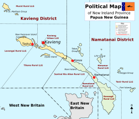
 New Ireland Province
| District | District Capital | LLG Name |
|---|---|---|
| Kavieng District Kavieng District Kavieng District is the northernmost district of New Ireland Province in Papua New Guinea. The district contains the northern part of the island of New Ireland, as well as New Hannover, and the St. Matthias Group.... |
Kavieng Kavieng Kavieng is the capital of the Papua New Guinean province of New Ireland and the largest town on the island of the same name. The town is located at Balgai Bay, on the northern tip of the island. As of 2000, it had a population of 10,600.... |
Kavieng Urban Kavieng Urban LLG The Kavieng Urban LLG is a local government area in New Ireland Province, Papua New Guinea. The LLG is located in Kavieng District and the LLG headquarters is Kavieng. This LLG has six wards. The area is a renowned habitat for the Nutrias or giant rats.... |
| Lavongai Rural Lavongai Rural LLG The Lavongai Rural LLG is a local government area in New Ireland Province, Papua New Guinea. The LLG administers the island of New Hanover and a few surrounding islands. The LLG is located in Kavieng District and the LLG headquarters is Taskul. Some population centres in the LLG are: Taskul,... |
||
| Murat Rural Murat Rural LLG The Murat Rural LLG is a local government area in New Ireland Province, Papua New Guinea. The LLG president is Derol Maisi. The LLG administers the St. Matthias Group of islands and is located in Kavieng District.... |
||
| Tikana Rural Tikana Rural LLG The Tikana Rural LLG is a local government area in New Ireland Province, Papua New Guinea. The LLG administers the northern section of the island of New Ireland, as well as Dyaul Island and some Tigak islands in the strait between New Ireland and New Hanover.... |
||
| Namatanai District Namatanai District Namatanai District is the southernmost and larger of the two districts of New Ireland Province in Papua New Guinea. The district covers the southern part of the island of New Ireland, as well as the Tabar Group, the Lihir Group, the Tangga Group and the Feni Islands.The district headquarters is... |
Namatanai Namatanai Namatanai is a town on the island province of New Ireland in Papua New Guinea. It is the second largest settlement on the island and connected to the largest and provincial capital of Kavieng by the Boluminski Highway. In 2005, Namantanai was estimated to have a population of 1300 people.During... |
Konoagil Rural Konoagil Rural LLG The Konoagil Rural LLG is a local government area in New Ireland Province, Papua New Guinea. The LLG administers the southern peninsula of the island of New Ireland. The LLG is located in Namatanai District.... |
| Namatanai Rural Namatanai Rural LLG The Namatanai Rural LLG is a local government area in New Ireland Province, Papua New Guinea. The LLG is located in Namatanai District and the LLG headquarters is Namatanai.... |
||
| Nimamar Rural Nimamar Rural LLG The Nimamar Rural LLG is a local government area in New Ireland Province, Papua New Guinea. The LLG administers the Lihir Group of islands. The LLG is located in Namatanai District and contains the Lihir Gold Mine, which is the second largest gold deposit in the world.The current LLG president is... |
||
| Sentral Niu Ailan Rural Sentral Niu Ailan Rural LLG The Sentral Niu Ailan Rural LLG is a local government area in New Ireland Province, Papua New Guinea. The LLG administers a central area of the island of New Ireland and the Tabar Group... |
||
| Tanir Rural Tanir Rural LLG The Tanir Rural LLG is a local government area in New Ireland Province, Papua New Guinea. The LLG administers the Tangga Group and the Feni Islands.The current LLG president is Bruno Parbil.... |
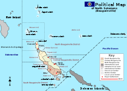
North Solomons Province (Bougainville)
| District | District Capital | LLG Name |
|---|---|---|
| Central Bougainville District Central Bougainville District Central Bougainville District is a district of the Autonomous Region of Bougainville of Papua New Guinea. Its capital is Arawa-Kieta.... |
Arawa Arawa, Papua New Guinea Arawa is the disputed capital and largest settlement in Bougainville Province in Papua New Guinea. The land where Arawa is now situated was previously a large expatriate plantation.... -Kieta Kieta Kieta is a port town located on the eastern coast of the island of Bougainville in Papua New Guinea, near the township of Arawa. After extensive destruction during the 1990 Civil Uprising on Bougainville, Kieta has few inhabitants now, and is known mainly for its transport connections .-History:On... |
Arawa Rural |
| Wakunai Rural | ||
| North Bougainville District North Bougainville District North Bougainville District is a district of the Autonomous Region of Bougainville of Papua New Guinea. Its capital is Buka.... |
Buka Buka, Papua New Guinea Buka is situated on Buka Island, Bougainville Province, Papua New Guinea. It has been the capital of the province during the Bougainville civil war... |
Atolls Rural |
| Buka Rural | ||
| Kunua Rural | ||
| Nissan Rural | ||
| Selau Suir Rural | ||
| Tinputz Rural | ||
| South Bougainville District South Bougainville District South Bougainville District is a district of the Autonomous Region of Bougainville of Papua New Guinea. Its capital is Buin.... |
Buin Buin, Papua New Guinea Buin is a settlement at the southern end of the island of Bougainville, a part of the North Solomons Province, located in the northern Solomon Islands in the South Pacific Ocean.-History:... |
Bana Rural |
| Buin Rural | ||
| Siwai Rural | ||
| Torokina Rural |
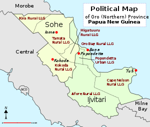
Oro (Northern) ProvinceOro ProvinceOro Province, formerly Northern Province, is a coastal province of Papua New Guinea. The provincial capital is Popondetta. The province covers 22,800 km², and has 133,065 inhabitants ....
| District | District Capital | LLG Name |
|---|---|---|
| Ijivitari District Ijivitari District Ijivitari District is a district of the Oro Province of Papua New Guinea. Its capital is Popondetta. The population was 67,558 at the 2000 census.... |
Popondetta Popondetta Popondetta is the capital of Oro Province in Papua New Guinea.In 1951 the town became the focus of relief efforts after nearby Mount Lamington erupted and killed 4,000 people.... |
Afore Rural |
| Cape Nelson Rural | ||
| Oro Bay Rural | ||
| Popendetta Urban | ||
| Sohe District Sohe District Sohe District is a district of the Oro Province of Papua New Guinea. Its capital is Kokoda. The population was 65,156 at the 2000 census.... |
Kokoda Kokoda Kokoda is a station town in the Oro Province of Papua New Guinea. It is famous as the northern end of the Kokoda Track, site of the eponymous Kokoda Track campaign of World War II. In that campaign, it had strategic significance because it had the only airfield along the Track... |
Higaturu Rural |
| Kira Rural | ||
| Kokoda Rural | ||
| Tamata Rural |
 Simbu ProvinceSimbu ProvinceSimbu, also known as Chimbu, is a Highlands Region province in Papua New Guinea. The province has an area of 6,100 km² and a population of 259,703 . The capital of the province is Kundiawa...
| District | District Capital | LLG Name |
|---|---|---|
| Chuave District Chuave District Chuave District is a district of the Simbu Province of Papua New Guinea. Its capital is Chuave. The population was 35,065 at the 2000 census.... |
Chuave | Chuave Rural |
| Elimbari Rural | ||
| Siane Rural | ||
| Gumine District Gumine District Gumine District is a district of the Simbu Province of Papua New Guinea. Its capital is Gumine. The population was 35,957 at the 2000 census.... |
Gumine | Bomai-Kumai Rural |
| Gumine Rural | ||
| Mount Digine Rural | ||
| Karimui-Nomane District Karimui-Nomane District Karimui-Nomane District is a district of the Simbu Province of Papua New Guinea. Its capital is Karimui. The population was 35,874 at the 2000 census.... |
Karimui | Karimui Rural |
| Nomane Rural | ||
| Salt Rural | ||
| Kerowagi District Kerowagi District Kerowagi District is one of six districts of the Simbu Province in Papua New Guinea. Its capital is Kerowagi and the district has three Local Level Government areas: Gena-Waugla Rural, Kerowagi Rural, and Kup Rural.... |
Kerowagi | Gena-Waugla Rural |
| Kerowagi Rural | ||
| Kup Rural | ||
| Kundiawa-Gembogl District Kundiawa-Gembogl District Kundiawa-Gembogl District is a district of the Simbu Province of Papua New Guinea. Its capital is Kundiawa. The population was 58,339 at the 2000 census.... |
Kundiawa Kundiawa Kundiawa is the capital of Simbu Province, Papua New Guinea, with a population of 8,147 . It lies along the Highlands Highway approximately halfway between Goroka and Mount Hagen, respectively the capitals of the Eastern Highlands and Western Highlands provinces.It is a relatively small town,... |
Kundiawa Urban |
| Mount Wilhelm Rural | ||
| Niglkande Rural | ||
| Waiye Rural | ||
| Sina Sina-Yonggomugl District Sina Sina-Yonggomugl District Sina Sina-Yonggomugl District is a district of the Simbu Province of Papua New Guinea. Its capital is Yonggomugl. The population was 37,676 at the 2000 census.... |
Yonggomugl | Sinasina Rural |
| Suwai Rural | ||
| Yonggomugl Rural |
Southern Highlands Province
| District | District Capital | LLG Name |
|---|---|---|
| Ialibu-Pangia District Ialibu-Pangia District Ialibu-Pangia District is a district of the Southern Highlands Province of Papua New Guinea. Its capital is Ialibu. The population was 50,243 at the 2000 census.... |
Ialibu Ialibu Ialibu is a town in the Southern Highlands Province of Papua New Guinea, serving as the headquarters for the Ialibu-Pangia District.-Culture:... |
East Pangia Rural |
| Ialibu Urban | ||
| Kewabi Rural | ||
| Wiru Rural | ||
| Imbonggu District Imbonggu District Imbonggu District is a district of the Southern Highlands Province of Papua New Guinea. Its capital is Imbonggu. The population was 59,813 at the 2000 census.... |
Imbonggu | Ialibu Basin Rural |
| Imbongu Rural | ||
| Lower Mendi Rural | ||
| Kagua-Erave District Kagua-Erave District Kagua-Erave District is a district of the Southern Highlands Province of Papua New Guinea. Its capital is Kagua. The population was 54,640 at the 2000 census.... |
Kagua | Erave Rural |
| Kagua Rural | ||
| Kuare Rural | ||
| Komo-Magarima District Komo-Magarima District Komo-Magarima District is a district of the Southern Highlands Province of Papua New Guinea. Its capital is Magarima. The population was 63,895 at the 2000 census.... |
Magarima | Hulia Rural |
| Komo Rural | ||
| Margarima Rural | ||
| Koroba-Kopiago District Koroba-Kopiago District Koroba-Kopiago District is a district of the Southern Highlands Province of Papua New Guinea. Its capital is Kopiago. The population was 69,465 at the 2000 census.... |
Kopiago | Awi-Pori Rural |
| Lake Kopiago Rural | ||
| North Koroba Rural | ||
| South Koroba Rural | ||
| Mendi-Munihu District Mendi-Munihu District Mendi-Munihu District is a district of the Southern Highlands Province of Papua New Guinea. Its capital is Mendi. The population was 96,137 at the 2000 census.... |
Mendi Mendi Mendi, Papua New Guinea, is the provincial capital of the Southern Highlands Province.... |
Karints Rural |
| Lai Valley Rural | ||
| Mendi Urban | ||
| Upper Mendi Rural | ||
| Nipa-Kutubu District Nipa-Kutubu District Nipa-Kutubu District is a district of the Southern Highlands Province of Papua New Guinea. Its capital is Nipa. The population was 98,261 at the 2000 census.... |
Nipa | Lake Kutubu Rural |
| Mount Bosavi Rural | ||
| Nembi Plateau Rural | ||
| Nipa Rural | ||
| Poroma Rural | ||
| Tari-Pori District Tari-Pori District Tari-Pori District is a district of the Southern Highlands Province of Papua New Guinea. Its capital is Tari. The population was 51,898 at the 2000 census.... |
Tari Tari, Papua New Guinea Tari Is the centre of Huli country in the Southern Highlands province of Papua New Guinea. It is the second largest settlement in the province, and accessible by road from Mendi.-Aviation Accidents:... |
Hayapuga Rural |
| Tagali Rural | ||
| Tari Urban | ||
| Tebi Rural |
Sandaun (West Sepik) Province
| District | District Capital | LLG Name |
|---|---|---|
| Aitape-Lumi District Aitape-Lumi District Aitape-Lumi District is a district of the Sandaun Province of Papua New Guinea. Its capital is Aitape.... |
Aitape Aitape Aitape is a small town of about 8,000 people on the north coast of Papua New Guinea in the Sandaun Province. It is a coastal settlement that is almost equidistant from the provincial capitals of Wewak and Vanimo, and marks the midpoint of the highway between these two capitals... |
East Aitape Rural |
| East Wapei Rural | ||
| West Aitape Rural | ||
| West Wapei Rural | ||
| Nuku District Nuku District Nuku District is a district of the Sandaun Province of Papua New Guinea. Its capital is Nuku.... |
Nuku Nuku Nuku was a traditional province of the island of Hiva Oa in pre-European times. It did not function as a unified governmental unit, but rather as a confederation of local tribes during times of war with tribes from Hiva Oa's other province, Pepane... |
Nuku Rural |
| Palai Rural | ||
| Yangkok Rural | ||
| Maimai Wanwan Rural | ||
| Telefomin District Telefomin District Telefomin District is a district of the Sandaun Province of Papua New Guinea. Its capital is Telefomin.... |
Telefomin Telefomin Telefomin is a station town on the border of Sandaun and Western Provinces in Papua New Guinea. The town started during the Second World War after Mick Leahy was assigned to engineer an air-strip in 1944 for the United States for use against the Imperial Japanese Army forces based in New Guinea.The... |
Namea Rural |
| Oksapmin Rural | ||
| Telefomin Rural | ||
| Yapsie Rural | ||
| Vanimo-Green River District Vanimo-Green River District Vanimo-Green River District is a district of the Sandaun Province of Papua New Guinea. Its capital is Vanimo.... |
Vanimo Vanimo Vanimo is the capital of Sandaun Province in Papua New Guinea. It is located on a peninsula close to the border with Indonesia.Vanimo is a small township with an economy based around the timber industry. Logging company Vanimo Forest Products, which is owned by Malaysian company Rimbunan Hijau, is... |
Amanab Rural |
| Bewani-Wutung-Onei Rural | ||
| Green River Rural | ||
| Vanimo Urban | ||
| Walsa Rural |
 West New Britain Province
| District | District Capital | LLG Name |
|---|---|---|
| Kandrian-Gloucester District Kandrian-Gloucester District Kandrian-Gloucester District is a district of the West New Britain Province of Papua New Guinea. Its capital is Kandrian.... |
Kandrian Kandrian Kandrian is the headquarters of Kandrian-Gloucester District, West New Britain Province, Papua New Guinea.... |
Gasmata Rural |
| Gloucester Rural | ||
| Kandrian Coastal Rural | ||
| Kandrian Inland Rural | ||
| Kove-Kaliai Rural | ||
| Talasea District Talasea District Talasea District is a district of the West New Britain Province of Papua New Guinea. Its capital is Kimbe.... |
Kimbe Kimbe Kimbe is the capital of the province of West New Britain in Papua New Guinea. It is a port town on the great Kimbe Bay which boasts more than 60 percent of the coral species of the entire Indo-Pacific. The bustling town of Kimbe is the third largest port in Papua New Guinea and is the fastest... |
Bali-Witu Rural |
| Bialla Rural | ||
| Hoskins Rural | ||
| Kimbe Urban | ||
| Mosa Rural | ||
| Talasea Rural |
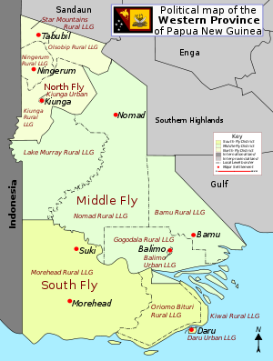
 Western (Fly) ProvinceWestern Province (Papua New Guinea)Western Province is a coastal province in southwestern Papua New Guinea, bordering the Indonesian province of Papua. The provincial capital is Daru, on the island of Daru. The largest town in the province is Tabubil...
| District | District Capital | LLG Name |
|---|---|---|
| North Fly District North Fly District, Western Province The North Fly District of the Western Province of Papua New Guinea is the northernmost, smallest, and arguably the most remote of the three districts of the province... |
Kiunga Kiunga, Papua New Guinea Kiunga is a port town on the Fly River in the Western Province of Papua New Guinea, just upstream from the D'Albertis Junction with the Ok Tedi River. It is the southernmost terminus of the Kiunga-Tabubil Highway. Local industry rests on a cornerstone of freight and haulage, particularly from the... |
Kiunga Rural Kiunga Rural LLG The Kiunga Rural LLG is a local level government area situated in the North Fly District of the Western Province of Papua New Guinea. In the year 2000, the LLG had a population of 13,249 people. The township of Kiunga is within the boundaries of this LLG, but has its own urban LLG.... |
| Kiunga Urban Kiunga Urban LLG The Kiunga Urban LLG is a local level government area situated in the North Fly District of the Western Province of Papua New Guinea. In the year 2000, the LLG had a population of 8265 people. The township of Kiunga, which is governed by this LLG is the government seat of the district.... |
||
| Ningerum Rural Ningerum Rural LLG The Ningerum Rural LLG is a local level government area situated in the North Fly District of the Western Province of Papua New Guinea. In the year 2000, the LLG had a population of 13,156 people. The main population centre is Ningerum.... |
||
| Olsobip Rural Olsobip Rural LLG The Olsobip Rural LLG is a local level government situated in the North Fly District of the Western Province of Papua New Guinea. In the year 2000, the LLG was the least populous of the district, with a population of only 3851 people. The capital of the LLG is a station town by the name of Olsobip.... |
||
| Star Mountains Rural Star Mountains Rural LLG The Star Mountains Rural LLG is a local level government situated in the Star Mountains in the North Fly District of the Western Province of Papua New Guinea. In the year 2000, the LLG had 1691 homes, and a population of 12,114 people. The current population is more likely to now be around 15,000... |
||
| Middle Fly District Middle Fly District, Western Province The Middle Fly District of the Western Province of Papua New Guinea is a large, coastal district that forms the central area of the Fly River basin. It contains the Local-Level Government areas of: Balimo Urban, Bamu Rural, Gogodaia Rural, Lake Murray Rural, and Nomad Rural, and the population... |
Balimo | Balimo Urban |
| Bamu Rural | ||
| Gogodala Rural | ||
| Lake Murray Rural | ||
| Nomad Rural | ||
| South Fly District South Fly District, Western Province South Fly District is a district of the Western Province of Papua New Guinea. Its capital is Daru. The population of the district was 46,407at the 2000 census.... |
Daru Daru Daru is the capital of the Western Province of Papua New Guinea. The township is entirely located on an island that goes by the same name, which is located near the mouth of the Fly River on the western side of the Gulf, just north of Torres Strait and Far North Queensland... |
Daru Urban |
| Kiwai Rural | ||
| Morehead Rural | ||
| Oriomo-Bituri Rural |
 Western Highlands Province
| District | District Capital | LLG Name |
|---|---|---|
| Anglimp-South Waghi District Anglimp-South Waghi District Anglimp-South Waghi District is a district of the Western Highlands Province of Papua New Guinea. Its capital is Minj. The population of the district was 96,413 at the 2000 census.... |
Minj | Anglimp Rural |
| South Waghi Rural | ||
| Dei District Dei District Dei District is a district of the Western Highlands Province of Papua New Guinea. Its capital is Dei. The population of the district was 50,033 at the 2000 census.... |
Dei | Muglamp Rural |
| Kotna Rural | ||
| Mount Hagen District Mount Hagen District Mount Hagen District is a district of the Western Highlands Province of Papua New Guinea. Its capital is Mount Hagen. The population of the district was 86,517 at the 2000 census.... |
Mount Hagen Mount Hagen Mount Hagen is third largest city in Papua New Guinea. It is the capital of the Western Highlands Province and is located in the large fertile Wahgi Valley in central mainland Papua New Guinea, at an elevation of .... |
Mount Hagen Rural |
| Mount Hagen Urban | ||
| Mul-Baiyer District Mul-Baiyer District Mul-Baiyer District is a district of the Western Highlands Province of Papua New Guinea. Its capital is Baiyer. The population of the district was 56,536 at the 2000 census.... |
Baiyer | Baiyer Rural |
| Lumusa Rural | ||
| Mul Rural | ||
| Jimi District Jimi District Jimi District is a district of the Western Highlands Province of Papua New Guinea. Its capital is Tabibuga. The population of the district was 37,479 at the 2000 census.... |
Tabibuga | Jimi Rural |
| Kol Rural | ||
| North Waghi District North Waghi District North Waghi District is a district of the Western Highlands Province of Papua New Guinea. Its capital is Banz. The population of the district was 51,282 at the 2000 census.... |
Banz | North Waghi Rural |
| Nondugl Rural | ||
| Tambul-Nebilyer District Tambul-Nebilyer District Tambul-Nebilyer District is a district of the Western Highlands Province of Papua New Guinea. Its capital is Nebilyer. The population of the district was 60,825 at the 2000 census.... |
Nebilyer | Mount Giluwe Rural |
| Nebilyer Rural | ||
See also
- Provinces of Papua New GuineaProvinces of Papua New GuineaThe provinces of Papua New Guinea are the primary administrative divisions of the country. Provincial governments are branches of the national government– Papua New Guinea is not a federation of provinces...
- List of regions of Papua New Guinea
- List of cities and towns in Papua New Guinea
- List of cities and towns in Papua New Guinea by population