

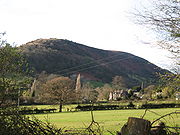
Cwmdu, Powys
Encyclopedia
Village
A village is a clustered human settlement or community, larger than a hamlet with the population ranging from a few hundred to a few thousand , Though often located in rural areas, the term urban village is also applied to certain urban neighbourhoods, such as the West Village in Manhattan, New...
situated in the heart of the Black Mountains
Black Mountains
There are several mountain ranges named the Black Mountains:* Black Mountains * Black Mountains * Black Mountains * Black Mountains * Black Mountains * Black Mountains...
in Powys
Powys
Powys is a local-government county and preserved county in Wales.-Geography:Powys covers the historic counties of Montgomeryshire and Radnorshire, most of Brecknockshire , and a small part of Denbighshire — an area of 5,179 km², making it the largest county in Wales by land area.It is...
, Wales
Wales
Wales is a country that is part of the United Kingdom and the island of Great Britain, bordered by England to its east and the Atlantic Ocean and Irish Sea to its west. It has a population of three million, and a total area of 20,779 km²...
. Its name is derived from the Welsh language
Welsh language
Welsh is a member of the Brythonic branch of the Celtic languages spoken natively in Wales, by some along the Welsh border in England, and in Y Wladfa...
"Cwm Ddu", which means 'Black Valley'. It is located on the A479 Talgarth
Talgarth
Talgarth is a small market town and community in southern Powys , Mid Wales, with a population of 1,645. Notable buildings in the town include its 14th-century parish church and 13th century Pele Tower, located in the town centre, now home to the Tourist Information and Resource Centre...
to Tretower road.
Amenities
Cwmdu has several public facilities, including a park, a garage, a church dedicated to St. Michael and ArchangelArchangel
An archangel is an angel of high rank. Archangels are found in a number of religious traditions, including Judaism, Christianity and Islam. Michael and Gabriel are recognized as archangels in Judaism and by most Christians. Michael is the only archangel specifically named in the Protestant Bible...
s http://www.geograph.org.uk/photo/318292, a campsite , a village school which was visited by Prince Charles in the summer of 2006 , a village pub, the Farmers Arms http://home.freeuk.com/thefarmersarms/around.html and a cafe, the Mynydd-Ddu Tea Room.
Cwmdu attracts many tourists every year, who mainly consist of hikers hillwalking
Hillwalking
In the British Isles, the terms hillwalking or fellwalking are commonly used to describe the recreational outdoor activity of walking on hills and mountains, often with the intention of visiting their summits...
through on the Beacons Way http://www.geograph.org.uk/photo/733738. Cwmdu is an attractive hiking destination as it is situated in the heart of the Black Mountains, and is only about 12 miles away from the Brecon Beacons
Brecon Beacons
The Brecon Beacons is a mountain range in South Wales. In a narrow sense, the name refers to the range of popular peaks south of Brecon, including South Wales' highest mountain, Pen y Fan, and which together form the central section of the Brecon Beacons National Park...
; the highest mountain range in South Wales and within the region's National Park
National park
A national park is a reserve of natural, semi-natural, or developed land that a sovereign state declares or owns. Although individual nations designate their own national parks differently A national park is a reserve of natural, semi-natural, or developed land that a sovereign state declares or...
.
Nearby towns include Crickhowell
Crickhowell
Crickhowell is a small town in Powys, Mid Wales.-Location:The name Crickhowell is taken from that of the nearby Iron Age hill fort of Crug Hywel above the town, the Welsh language name being anglicised by map-makers and local English-speaking people...
; a small market town
Market town
Market town or market right is a legal term, originating in the medieval period, for a European settlement that has the right to host markets, distinguishing it from a village and city...
which is famous for its beautiful 16th century river bridge across the River Usk
River Usk
The River Usk rises on the northern slopes of the Black Mountain of mid-Wales, in the easternmost part of the Brecon Beacons National Park. Initially it flows north into Usk Reservoir, then east by Sennybridge to Brecon before turning southeast to flow by Talybont-on-Usk, Crickhowell and...
and a range of quaint shops. Abergavenny
Abergavenny
Abergavenny , meaning Mouth of the River Gavenny, is a market town in Monmouthshire, Wales. It is located 15 miles west of Monmouth on the A40 and A465 roads, 6 miles from the English border. Originally the site of a Roman fort, Gobannium, it became a medieval walled town within the Welsh Marches...
is also found nearby over the border with Monmouthshire
Monmouthshire
Monmouthshire is a county in south east Wales. The name derives from the historic county of Monmouthshire which covered a much larger area. The largest town is Abergavenny. There are many castles in Monmouthshire .-Historic county:...
; a larger market town than Crickhowell, it is also popular with ramblers because of its 'Three Peaks'; the Sugar Loaf Mountain, Wales
Sugar Loaf Mountain, Wales
Sugar Loaf, sometimes called The Sugar Loaf , is a mountain situated north-west of Abergavenny in Monmouthshire, Wales. It is the most southern and lowest of the summit peaks of the Black Mountains, with a height of 1,955 feet ....
, the Blorenge
Blorenge
The Blorenge or simply Blorenge is a prominent hill which overlooks the valley of the River Usk in Monmouthshire, southeast Wales. It is situated in the southeastern corner of the Brecon Beacons National Park. The summit plateau reaches a height of ....
and the Skirrid.