
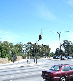
Cross Road, Adelaide
Encyclopedia
Australia
Australia , officially the Commonwealth of Australia, is a country in the Southern Hemisphere comprising the mainland of the Australian continent, the island of Tasmania, and numerous smaller islands in the Indian and Pacific Oceans. It is the world's sixth-largest country by total area...
n city of Adelaide
Adelaide
Adelaide is the capital city of South Australia and the fifth-largest city in Australia. Adelaide has an estimated population of more than 1.2 million...
. Its western terminus is at Anzac Highway
Anzac Highway, Adelaide
The Anzac Highway is an 11 kilometre main arterial road heading southwest from the city of Adelaide, the capital of South Australia, to the beachside suburb of Glenelg....
, travelling east and ending at Glen Osmond
Glen Osmond, South Australia
Glen Osmond is a small suburb of Adelaide, South Australia in the City of Burnside located in the foothills of the Adelaide Hills.-References:...
and the Adelaide Hills
Adelaide Hills
The Adelaide Hills are part of the Mount Lofty Ranges, east of the city of Adelaide in the state of South Australia. It is unofficially centred on the largest town in the area, Mount Barker, which has a population of around 29,000 and is also one of Australia's fastest growing towns.- History :The...
, joining the junction of Glen Osmond Road
Glen Osmond Road, Adelaide
Glen Osmond Road is a major state Highway 1 road in the city of Adelaide, South Australia. Connecting the Adelaide city centre with the Adelaide Hills via the Adelaide-Crafers Highway; Glen Osmond Road carries half of Adelaide's freight traffic and is the major hills commuter route...
, Portrush Road
Portrush Road, Adelaide
Portrush Road is a major part of National Route A17, a bypass route in Adelaide, the capital of South Australia.It runs north-south through the south-eastern and eastern suburbs of Adelaide, at the foot of the Adelaide Hills...
, and Mount Barker Road.
There are two railway level crossings along Cross Road, one at Unley Park and another larger one at Emerson Crossing
Emerson Crossing
Emerson Crossing, the 'South Road Overpass' or simply 'the Overpass' are the informal names given to the intersection of South Road, Cross Road and the Noarlunga Centre railway line in Adelaide, South Australia. South Road crosses north-south over both Cross Road and the diagonal railway via a...
. This is also where South Road
South Road, Adelaide
South Road is a major north–south conduit in Adelaide, South Australia. Also known as Main South Road, it is Adelaide's most important arterial road.- Route :...
crosses over a large overpass built between 1982 and 1984, to reduce the traffic congestion which builds up during peak hour times.
There are a number of suburbs which Cross Road passes through and borders. These are:
- Black ForestBlack Forest, South AustraliaBlack Forest is an inner southern suburb of Adelaide, South Australia. It is located in the City of Unley.-History:There have been three Post Offices named Black Forest; the first opened on 1 September 1899 and was renamed Glandore in 1915, the second opened on 10 November 1947 and was renamed...
- Clarence GardensClarence Gardens, South AustraliaClarence Gardens is an inner southern suburb of Adelaide, South Australia in the City of Mitcham.It is bounded to the north by Cross Road, the west by South Road, the east by Winston Avenue and the south by Edward Street....
- Clarence ParkClarence Park, South AustraliaClarence Park is an inner southern suburb of Adelaide, South Australia in the City of Unley. Its borders are Mills Street , the Noarlunga railway line , Goodwood Road and Cross Road .-History:Goodwood Park Post Office opened on 27 December 1877, was renamed Goodwood South in...
- Cumberland ParkCumberland Park, South AustraliaCumberland Park is an inner southern suburb of Adelaide, South Australia in the City of Mitcham.The suburb's borders are Cross Road, Goodwood Road, Edward Street and Winston Avenue....
- EdwardstownEdwardstown, South AustraliaEdwardstown is an inner Southern suburb located 6 km southwest of Adelaide in the City of Marion.Edwardstown is in the South Australian House of Assembly Electoral district of Elder and the Australian House of Representatives Division of Hindmarsh. Edwardstown is home to the Castle Plaza Shopping...
- GlandoreGlandore, South AustraliaGlandore is a suburb of Adelaide, South Australia, partly in the City of Marion and partly in the City of West Torrens. The name is believed to come from Glandore in County Cork, Ireland, from whence came the family of John O'Dea, one of the original property owners of the area.Glandore lies...
- Glen OsmondGlen Osmond, South AustraliaGlen Osmond is a small suburb of Adelaide, South Australia in the City of Burnside located in the foothills of the Adelaide Hills.-References:...
- HawthornHawthorn, South AustraliaHawthorn is a suburb of Adelaide in the City of Mitcham. It is bounded to the north by Cross Road, to the south by Grange Road, to the west by Sussex Terrace and to the east by Belair Road.The Belair train line runs through the suburb....
- HighgateHighgate, South Australia-Education:*Highgate school is a 10 minute drive from the Adelaide CBD. It employs 65 staff. *Concordia College is a Lutheran secondary school.-References:...
- Kings ParkKings Park, South AustraliaKings Park is a small, triangular shaped suburb of Adelaide in the City of Unley surrounded by Goodwood Road, Cross Road and the Belair railway line. The nearest railway station is Unley Park.-References:...
- KingswoodKingswood, South AustraliaKingswood is a suburb of the Australian city of Adelaide in the City of Mitcham. It is bordered in the west by Belair Road, to the north by Cross Road, to the south by Princess Road and to the east by Smith Dorrien Street....
- MalvernMalvern, South AustraliaMalvern is an inner-southern suburb of Adelaide in the City of Unley. It borders adjacent suburbs of Unley and Parkside to the north, Highgate to the east, Kingswood to the south and Unley Park to the west...
- Mrytle BankMyrtle Bank, South AustraliaMyrtle Bank is a suburb of Adelaide, South Australia in the City of Unley. The suburb is named after a property near the foothills built in 1842 by William Sanders , who arrived in South Australia in 1838. He named the premises 'Myrtle Bank', because his friend James Gall of Trinity living in...
- NetherbyNetherby, South AustraliaNetherby is a suburb of Adelaide, South Australia in the City of Mitcham.Unley High School and Urrbrae Agricultural High School are located in the suburb.-References:...
- PlymptonPlympton, South AustraliaPlympton is a suburb of the city of Adelaide, South Australia. The name is believed to have been given by Henry Mooringe Boswarva to a private subdivision in the area, naming after his home town in Devon, England...
- Plympton ParkPlympton Park, South AustraliaPlympton Park is a south-western suburb o9f Adelaide 8km from the CBD, in the state of South Australia, Australia and falls under the City of Marion. The post code for Plympton Park is 5038. It is adjacent to Park Holme, Plympton, South Plympton, and Morphettville...
- South PlymptonSouth Plympton, South AustraliaSouth Plympton is a suburb of Adelaide in the City of Marion. South Plympton's postcode is 5038, its post office is located at Forbes Shopping centre on Marion Road....
- Unley ParkUnley Park, South AustraliaUnley Park is a southern suburb of Adelaide in the City of Unley. Its postcode is 5061.It is located on the north side of Cross Road and east of the Belair railway line...
- UrrbraeUrrbrae, South AustraliaUrrbrae is a suburb of Adelaide, South Australia. It is located in the City of Mitcham.Located at the foot of the Adelaide Hills, it is bordered on the east by the South Eastern Freeway, and the Old Toll House, which marked the traditional entrance to the city of Adelaide in the 19th...
- Westbourne ParkWestbourne Park, South AustraliaWestbourne Park is an inner southern suburb of the State capital of South Australia, Adelaide. The suburb was named after Westbourne, a village in Sussex, England, and was laid out in 1881.-History:It was originally known as Cottonville and Unley Park...