

Cornell, Wisconsin
Encyclopedia
Cornell is a city in Chippewa County
in the U.S. state
of Wisconsin
. The population was 1,466 at the 2000 census. It is located on the Chippewa River
, upstream from Lake Wissota
and Chippewa Falls.
is adjacent to the city. The northern trailhead for the Old Abe State Trail
, a paved rail-trail, is located downtown.
Cornell has the world's only surviving pulpwood stacker. The stacker helped to launch the huge timber industry in the Northwoods of Wisconsin in the late 19th century and early 20th century. It was used to move large quantities of pulpwood logs, making the process of stacking wood faster, safer, and easier. The stacker has been unused since 1972, but is considered a historical treasure. An annual town fair, known as the Stacker Festival, continues today.
According to the United States Census Bureau
, the city has a total area of 4.3 square miles (11.3 km2), of which, 3.8 square miles (9.9 km2) of it is land and 0.5 square miles (1.3 km2) of it (11.72%) is water.
As of the census
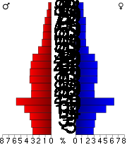
of 2000, there were 1,466 people, 607 households, and 392 families residing in the city. The population density
was 382.6 people per square mile (147.8/km2). There were 652 housing units at an average density of 170.2 per square mile (65.7/km2). The racial makeup of the city was 98.50% White, 0.95% Native American, 0.27% Asian, 0.07% Pacific Islander, 0.07% from other races
, and 0.14% from two or more races. Hispanic or Latino of any race were 0.34% of the population.
There were 607 households out of which 32.8% had children under the age of 18 living with them, 49.9% were married couples
living together, 11.7% had a female householder with no husband present, and 35.3% were non-families. 31.5% of all households were made up of individuals and 17.8% had someone living alone who was 65 years of age or older. The average household size was 2.34 and the average family size was 2.89.
In the city the population was spread out with 26.5% under the age of 18, 5.9% from 18 to 24, 24.8% from 25 to 44, 21.1% from 45 to 64, and 21.8% who were 65 years of age or older. The median age was 39 years. For every 100 females there were 91.6 males. For every 100 females age 18 and over, there were 80.6 males.
The median income for a household in the city was $30,690, and the median income for a family was $38,313. Males had a median income of $30,776 versus $19,808 for females. The per capita income
for the city was $15,494. About 6.8% of families and 8.9% of the population were below the poverty line, including 10.1% of those under age 18 and 5.8% of those age 65 or over.
Chippewa County, Wisconsin
Chippewa County is a county located in the U.S. state of Wisconsin. As of 2000, the population was 55,195. Its county seat is Chippewa Falls. The United States Census Bureau's Eau Claire Metropolitan Statistical Area includes all of Chippewa County...
in the U.S. state
U.S. state
A U.S. state is any one of the 50 federated states of the United States of America that share sovereignty with the federal government. Because of this shared sovereignty, an American is a citizen both of the federal entity and of his or her state of domicile. Four states use the official title of...
of Wisconsin
Wisconsin
Wisconsin is a U.S. state located in the north-central United States and is part of the Midwest. It is bordered by Minnesota to the west, Iowa to the southwest, Illinois to the south, Lake Michigan to the east, Michigan to the northeast, and Lake Superior to the north. Wisconsin's capital is...
. The population was 1,466 at the 2000 census. It is located on the Chippewa River
Chippewa River (Wisconsin)
The Chippewa River in Wisconsin flows approximately 183 miles through west-central and northwestern Wisconsin. It was once navigable for approximately 50 miles of its length, from the Mississippi River, by Durand, northeast to Eau Claire. Its catchment defines a portion of the northern boundary...
, upstream from Lake Wissota
Lake Wissota
Lake Wissota is a reservoir in Chippewa County, Wisconsin, USA, just east of the city of Chippewa Falls. It covers an area of and has a maximum depth of . The lake was formed by the construction of a hydroelectric dam on the Chippewa River, completed in 1917. The dam was built by the...
and Chippewa Falls.
Attractions
Brunet Island State ParkBrunet Island State Park
Brunet Island State Park is a Wisconsin state park just north of Cornell. The park features a island in the Chippewa River, with the remaining area on the east bank of the river. The park is noted for its numerous white-tailed deer and large eastern hemlock trees...
is adjacent to the city. The northern trailhead for the Old Abe State Trail
Old Abe State Trail
Old Abe State Trail is a paved multi-use rail trail in Chippewa County, Wisconsin, USA.The name commemorates Old Abe, an orphaned bald eagle found in the area in 1861 which became the mascot of the 8th Wisconsin Volunteer Infantry Regiment in the American Civil War...
, a paved rail-trail, is located downtown.
Cornell has the world's only surviving pulpwood stacker. The stacker helped to launch the huge timber industry in the Northwoods of Wisconsin in the late 19th century and early 20th century. It was used to move large quantities of pulpwood logs, making the process of stacking wood faster, safer, and easier. The stacker has been unused since 1972, but is considered a historical treasure. An annual town fair, known as the Stacker Festival, continues today.
Geography
Cornell is located at 45.165328°N 91.149044°W (45.165328, -91.149044).According to the United States Census Bureau
United States Census Bureau
The United States Census Bureau is the government agency that is responsible for the United States Census. It also gathers other national demographic and economic data...
, the city has a total area of 4.3 square miles (11.3 km2), of which, 3.8 square miles (9.9 km2) of it is land and 0.5 square miles (1.3 km2) of it (11.72%) is water.
Demographics
As of the census
Census
A census is the procedure of systematically acquiring and recording information about the members of a given population. It is a regularly occurring and official count of a particular population. The term is used mostly in connection with national population and housing censuses; other common...
of 2000, there were 1,466 people, 607 households, and 392 families residing in the city. The population density
Population density
Population density is a measurement of population per unit area or unit volume. It is frequently applied to living organisms, and particularly to humans...
was 382.6 people per square mile (147.8/km2). There were 652 housing units at an average density of 170.2 per square mile (65.7/km2). The racial makeup of the city was 98.50% White, 0.95% Native American, 0.27% Asian, 0.07% Pacific Islander, 0.07% from other races
Race (United States Census)
Race and ethnicity in the United States Census, as defined by the Federal Office of Management and Budget and the United States Census Bureau, are self-identification data items in which residents choose the race or races with which they most closely identify, and indicate whether or not they are...
, and 0.14% from two or more races. Hispanic or Latino of any race were 0.34% of the population.
There were 607 households out of which 32.8% had children under the age of 18 living with them, 49.9% were married couples
Marriage
Marriage is a social union or legal contract between people that creates kinship. It is an institution in which interpersonal relationships, usually intimate and sexual, are acknowledged in a variety of ways, depending on the culture or subculture in which it is found...
living together, 11.7% had a female householder with no husband present, and 35.3% were non-families. 31.5% of all households were made up of individuals and 17.8% had someone living alone who was 65 years of age or older. The average household size was 2.34 and the average family size was 2.89.
In the city the population was spread out with 26.5% under the age of 18, 5.9% from 18 to 24, 24.8% from 25 to 44, 21.1% from 45 to 64, and 21.8% who were 65 years of age or older. The median age was 39 years. For every 100 females there were 91.6 males. For every 100 females age 18 and over, there were 80.6 males.
The median income for a household in the city was $30,690, and the median income for a family was $38,313. Males had a median income of $30,776 versus $19,808 for females. The per capita income
Per capita income
Per capita income or income per person is a measure of mean income within an economic aggregate, such as a country or city. It is calculated by taking a measure of all sources of income in the aggregate and dividing it by the total population...
for the city was $15,494. About 6.8% of families and 8.9% of the population were below the poverty line, including 10.1% of those under age 18 and 5.8% of those age 65 or over.