

Coqueiral
Encyclopedia
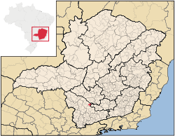
Minas Gerais
Minas Gerais is one of the 26 states of Brazil, of which it is the second most populous, the third richest, and the fourth largest in area. Minas Gerais is the Brazilian state with the largest number of Presidents of Brazil, the current one, Dilma Rousseff, being one of them. The capital is the...
. In 2007 the population was 9,466 in a total area of 297 km². The municipal seat lies at an elevation of 844 meters. It became a municipality in 1948.
Coqueiral belongs to the IBGE statistical microregion of Varginha
Varginha
Varginha is a city and municipality in southwest Minas Gerais state, Brazil. The estimated population is approximately 120,000 inhabitants and the area of the municipality is 396.39 km²...
. It is located north of Varginha
Varginha
Varginha is a city and municipality in southwest Minas Gerais state, Brazil. The estimated population is approximately 120,000 inhabitants and the area of the municipality is 396.39 km²...
and Três Pontas
Três Pontas
Três Pontas is a city and municipality in southern Minas Gerais state, Brazil. The population in 2007 was 51,121 inhabitants in a total area of 689 km²....
, west of Lavras
Lavras
Lavras is a city and municipality in Southern Minas Gerais state, Brazil. Located at an altitude of 900 m, it has an approximate population of 80,000 inhabitants. The area of the municipality is 566.1 km²...
, and northeast of Alfenas
Alfenas
Alfenas is a city and municipality in the southern part of the Brazilian state of Minas Gerais state. In 2007 its population was 71,628 and the area of the municipality is 849 km2. The elevation is 888m. It is served by highways MG 179, BR 491 and BR 369. The distance to the state capital...
. The regional center of Varginha
Varginha
Varginha is a city and municipality in southwest Minas Gerais state, Brazil. The estimated population is approximately 120,000 inhabitants and the area of the municipality is 396.39 km²...
is 57 km. away.
The main economic activities are milk production, coffee growing (7,200 hectares in 2006), and the cultivation of beans, corn, and sugarcane. In 2006 there were 808 rural producers with total agricultural area of 22,649 hectares. More than 2,000 persons worked in agriculture. In the town itself there was one financial institution.
In the health sector there were 6 public clinics and 1 private clinic. There were no hospitals, the closest hospital being in Três Pontas
Três Pontas
Três Pontas is a city and municipality in southern Minas Gerais state, Brazil. The population in 2007 was 51,121 inhabitants in a total area of 689 km²....
, 31 km. away. In the educational sector there were 13 primary schools and 1 middle school.
Municipal Human Development Index
Human Development Index
The Human Development Index is a composite statistic used to rank countries by level of "human development" and separate "very high human development", "high human development", "medium human development", and "low human development" countries...
- MHDI: .751
- State ranking: 272 out of 853 municipalities
- National ranking: 1,842 out of 5,138 municipalities
- Life expectancy: 72 years at birth
- Literacy rate: 87% (See Frigoletto for the complete list)