
Conway, Washington
Encyclopedia
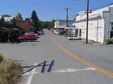
Conway is a census-designated place
(CDP) in Skagit County, Washington
, United States. First settled in 1873 by Thomas P. Jones and Charles Villeneuves, its population was 91 at the 2010 census. It is included in the Mount Vernon
–Anacortes
, Washington Metropolitan Statistical Area.
According to the United States Census Bureau
, the CDP has a total area of 0.3 square miles (0.7 km2), all of it land.
The Conway school district has no high school; parents are permitted to send their children to any of the surrounding high schools, including Stanwood, Mount Vernon, or LaConner. The majority of high school students residing in Conway attend Mount Vernon High School, as it is the only high school that provides a bus to the Conway area.
There were 28 households out of which 50.0% had children under the age of 18 living with them, 64.3% were married couples living together, 10.7% had a female householder with no husband present, and 17.9% were non-families. 10.7% of all households were made up of individuals and 3.6% had someone living alone who was 65 years of age or older. The average household size was 3.00 and the average family size was 3.22.
In the CDP the age distribution of the population shows 33.3% under the age of 18, 4.8% from 18 to 24, 33.3% from 25 to 44, 22.6% from 45 to 64, and 6.0% who were 65 years of age or older. The median age was 36 years. For every 100 females there were 104.9 males. For every 100 females age 18 and over, there were 107.4 males.
The median income for a household in the CDP was $33,750, and the median income for a family was $28,750. The per capita income
for the CDP was $12,206. None of the population or families were below the poverty line.
Census-designated place
A census-designated place is a concentration of population identified by the United States Census Bureau for statistical purposes. CDPs are delineated for each decennial census as the statistical counterparts of incorporated places such as cities, towns and villages...
(CDP) in Skagit County, Washington
Skagit County, Washington
Skagit County is a county in the U.S. state of Washington. It is named after the Skagit Indian tribe. As of 2010, the population was 116,901. It is included in the Mount Vernon-Anacortes, Washington, Metropolitan Statistical Area...
, United States. First settled in 1873 by Thomas P. Jones and Charles Villeneuves, its population was 91 at the 2010 census. It is included in the Mount Vernon
Mount Vernon, Washington
Mount Vernon is a city in Skagit County, Washington, United States. The population was 31,743 at the 2010 census. It is one of two principal cities of and included in the Mount Vernon-Anacortes, Washington Metropolitan Statistical Area. It is the county seat of Skagit County...
–Anacortes
Anacortes, Washington
Anacortes is a city in Skagit County, Washington, United States. The name "Anacortes" is a consolidation of the name Anna Curtis, who was the wife of early Fidalgo Island settler Amos Bowman. Anacortes' population was 15,778 at the time of the 2010 census...
, Washington Metropolitan Statistical Area.
Geography
Conway is located at 48.340856°N 122.343551°W (48.340856, -122.343551).According to the United States Census Bureau
United States Census Bureau
The United States Census Bureau is the government agency that is responsible for the United States Census. It also gathers other national demographic and economic data...
, the CDP has a total area of 0.3 square miles (0.7 km2), all of it land.
Education
Children attend school at Conway Elementary School from Kindergarten through the 8th grade. The school mascot is the Cougar and school colors are blue and gold. There are 2 teachers per grade level and a teacher to student ratio of roughly 1:30.The Conway school district has no high school; parents are permitted to send their children to any of the surrounding high schools, including Stanwood, Mount Vernon, or LaConner. The majority of high school students residing in Conway attend Mount Vernon High School, as it is the only high school that provides a bus to the Conway area.
Demographics
As of the census of 2000, there were 84 people, 28 households, and 22 families residing in the CDP. The population density was 324.9 people per square mile (124.7/km2). There were 29 housing units at an average density of 112.2/sq mi (43.1/km2). The racial makeup of the CDP was 95.24% White, and 4.76% from two or more races. Hispanic or Latino of any race were 8.33% of the population.There were 28 households out of which 50.0% had children under the age of 18 living with them, 64.3% were married couples living together, 10.7% had a female householder with no husband present, and 17.9% were non-families. 10.7% of all households were made up of individuals and 3.6% had someone living alone who was 65 years of age or older. The average household size was 3.00 and the average family size was 3.22.
In the CDP the age distribution of the population shows 33.3% under the age of 18, 4.8% from 18 to 24, 33.3% from 25 to 44, 22.6% from 45 to 64, and 6.0% who were 65 years of age or older. The median age was 36 years. For every 100 females there were 104.9 males. For every 100 females age 18 and over, there were 107.4 males.
The median income for a household in the CDP was $33,750, and the median income for a family was $28,750. The per capita income
Per capita income
Per capita income or income per person is a measure of mean income within an economic aggregate, such as a country or city. It is calculated by taking a measure of all sources of income in the aggregate and dividing it by the total population...
for the CDP was $12,206. None of the population or families were below the poverty line.