
Connecticut Route 71
Encyclopedia
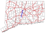
Route 71 is a north–south state highway
in Connecticut
, running from Wallingford
to West Hartford
. It is the main north–south road of Meriden
, Berlin
and New Britain
.
in Wallingford and heads north through Meriden
, Berlin
, and New Britain
, serving as the towns' main north–south street. It then cuts across the southeast corner of Farmington
and the northwest corner of Newington
before crossing into West Hartford, where it ends at an intersection with Route 173
. Route 71 has interchanges with five freeways along its 19 miles (30.6 km) route.
as a route between downtown New Britain
and Hartford
. In the 1920s, this was part of State Highway 113, which ran from Plainville
via New Britain to Hartford. The Plainville to New Britain section became part of Route 72
(now Route 372) in 1932. In 1934, the route was modified at both ends. The northern end was truncated to end at the Colt Highway (U.S. Route 6A), roughly at the location of Exit 40 of I-84. The south end was extended to U.S. Route 5A in Meriden
via Kensington
along Chamberlain Highway, Bradley Avenue, and Hanover Road (former State Highway 178). In 1962, US 5A in Meriden was removed and Route 71 south of West Main Street was relocated to the former US 5A alignment (Cook Avenue and Old Colony Road). In 1969, Route 71 was extended to its current northern end at Route 173 in West Hartford after US 6 was relocated to I-84 (US 6A became US 6 in the early 1940s).
Route 71 was once planned to be a freeway south from the planned southwestern Interstate 291
to the Route 72
freeway in 1961. In 1963, the state increased the planned mileage by planning the freeway to travel further north of I-291
to the Cedar Ridge Connector/Old Route 9
(remnants of which are now SR 504). The 1961 plan was built in 1986 as SR 506 but the rest of the Route 71 freeway was cancelled. Interestingly enough, in 1989, Route 9
became the southern terminus of the Route 71 freeway instead of the northern terminus. Route 9
was newly constructed west to, and extended onto the existing Route 72
freeway near Berlin
and onto SR 506. The Route 72
designation was scaled back westward to the old interchange with SR 506.
and heads northward along High Road, briefly overlapping Route 372
. It continues into New Britain
, where it becomes Kensington Avenue, and ends half a mile later at an intersection with Buell Street. The road continues beyond Buell Street as a local road. Route 71A originally extended further north to connect back to Route 71 but was truncated to its present end in 1995. Some signage for Route 71A still exists north of the official northern terminus.
State highway
State highway, state road or state route can refer to one of three related concepts, two of them related to a state or provincial government in a country that is divided into states or provinces :#A...
in Connecticut
Connecticut
Connecticut is a state in the New England region of the northeastern United States. It is bordered by Rhode Island to the east, Massachusetts to the north, and the state of New York to the west and the south .Connecticut is named for the Connecticut River, the major U.S. river that approximately...
, running from Wallingford
Wallingford, Connecticut
Wallingford is a town in New Haven County, Connecticut, United States. The population was 43,026 at the 2000 census.- History :Wallingford was established on October 10, 1667, when the Connecticut General Assembly authorized the "making of a village on the east river" to 38 planters and freemen...
to West Hartford
West Hartford, Connecticut
West Hartford is a town located in Hartford County, Connecticut, United States. The town was incorporated in 1854. Prior to that date, the town was a parish of Hartford....
. It is the main north–south road of Meriden
Meriden, Connecticut
Meriden is a city in New Haven County, Connecticut, United States. According to 2005 Census Bureau estimates, the population of the city is 59,653.-History:...
, Berlin
Berlin, Connecticut
Berlin is a town in Hartford County, Connecticut, United States. The population was 19,866 at the 2010 census. It was incorporated in 1785. The geographic center of Connecticut is located in the town. Berlin is residential and industrial, and served by the Amtrak station of the same name...
and New Britain
New Britain, Connecticut
New Britain is a city in Hartford County, Connecticut, United States. It is located approximately 9 miles southwest of Hartford. According to 2006 Census Bureau estimates, the population of the city is 71,254....
.
Route description
Route 71 begins at an intersection with US 5U.S. Route 5
U.S. Route 5 is a north–south United States highway running through the New England states of Connecticut, Massachusetts, and Vermont. Significant cities along the route include New Haven, Connecticut; Hartford, Connecticut; and Springfield, Massachusetts. From Hartford northward to St...
in Wallingford and heads north through Meriden
Meriden, Connecticut
Meriden is a city in New Haven County, Connecticut, United States. According to 2005 Census Bureau estimates, the population of the city is 59,653.-History:...
, Berlin
Berlin, Connecticut
Berlin is a town in Hartford County, Connecticut, United States. The population was 19,866 at the 2010 census. It was incorporated in 1785. The geographic center of Connecticut is located in the town. Berlin is residential and industrial, and served by the Amtrak station of the same name...
, and New Britain
New Britain, Connecticut
New Britain is a city in Hartford County, Connecticut, United States. It is located approximately 9 miles southwest of Hartford. According to 2006 Census Bureau estimates, the population of the city is 71,254....
, serving as the towns' main north–south street. It then cuts across the southeast corner of Farmington
Farmington, Connecticut
Farmington is a town located in Hartford County in the Farmington Valley area of central Connecticut in the United States. The population was 25,340 at the 2010 census. It is home to the world headquarters of several large corporations including Carrier Corporation, Otis Elevator Company, and Carvel...
and the northwest corner of Newington
Newington, Connecticut
Newington is a town in Hartford County, Connecticut, United States. As of the 2000 census, it had a total population of 29,306. The Connecticut Department of Transportation has its headquarters in Newington....
before crossing into West Hartford, where it ends at an intersection with Route 173
Connecticut Route 173
Route 173 is a Connecticut state highway in the southern and western suburbs of Hartford, running from Newington to West Hartford.-Route description:...
. Route 71 has interchanges with five freeways along its 19 miles (30.6 km) route.
History
Route 71 was established in the 1932 state highway renumbering1932 state highway renumbering (Connecticut)
In 1932, the Highway Department of the U.S. state of Connecticut , decided to completely renumber all its state highways. The only exceptions were the U.S. Highways and some of the New England Interstate Routes. Between 1922 and 1932, Connecticut used a state highway numbering system shared with...
as a route between downtown New Britain
New Britain, Connecticut
New Britain is a city in Hartford County, Connecticut, United States. It is located approximately 9 miles southwest of Hartford. According to 2006 Census Bureau estimates, the population of the city is 71,254....
and Hartford
Hartford, Connecticut
Hartford is the capital of the U.S. state of Connecticut. The seat of Hartford County until Connecticut disbanded county government in 1960, it is the second most populous city on New England's largest river, the Connecticut River. As of the 2010 Census, Hartford's population was 124,775, making...
. In the 1920s, this was part of State Highway 113, which ran from Plainville
Plainville, Connecticut
Plainville is a town in Hartford County, Connecticut, United States. The population was 17,328 at the 2000 census.-Geography:According to the United States Census Bureau, the town has a total area of 9.8 square miles , of which 9.8 square miles is land and 0.1 square miles is water...
via New Britain to Hartford. The Plainville to New Britain section became part of Route 72
Route 72 (Connecticut)
Route 72 is a state highway in the western part of the Greater Hartford area. Route 72 is an L-shaped route with a north–south section in Plymouth and Harwinton and an east–west section from Bristol to New Britain...
(now Route 372) in 1932. In 1934, the route was modified at both ends. The northern end was truncated to end at the Colt Highway (U.S. Route 6A), roughly at the location of Exit 40 of I-84. The south end was extended to U.S. Route 5A in Meriden
Meriden, Connecticut
Meriden is a city in New Haven County, Connecticut, United States. According to 2005 Census Bureau estimates, the population of the city is 59,653.-History:...
via Kensington
Kensington, Connecticut
Kensington is a census-designated place and section of the town of Berlin in Hartford County, Connecticut, United States. The Berlin town offices are located in Kensington...
along Chamberlain Highway, Bradley Avenue, and Hanover Road (former State Highway 178). In 1962, US 5A in Meriden was removed and Route 71 south of West Main Street was relocated to the former US 5A alignment (Cook Avenue and Old Colony Road). In 1969, Route 71 was extended to its current northern end at Route 173 in West Hartford after US 6 was relocated to I-84 (US 6A became US 6 in the early 1940s).
Route 71 was once planned to be a freeway south from the planned southwestern Interstate 291
Interstate 291 (Connecticut)
Interstate 291 is a short Interstate Highway in the state of Connecticut that starts at I-91 at its junction with Route 218 in Windsor and ends at I-84 in Manchester. It serves as a northeastern bypass of Hartford...
to the Route 72
Route 72 (Connecticut)
Route 72 is a state highway in the western part of the Greater Hartford area. Route 72 is an L-shaped route with a north–south section in Plymouth and Harwinton and an east–west section from Bristol to New Britain...
freeway in 1961. In 1963, the state increased the planned mileage by planning the freeway to travel further north of I-291
Interstate 291 (Connecticut)
Interstate 291 is a short Interstate Highway in the state of Connecticut that starts at I-91 at its junction with Route 218 in Windsor and ends at I-84 in Manchester. It serves as a northeastern bypass of Hartford...
to the Cedar Ridge Connector/Old Route 9
Route 9 (Connecticut)
Route 9 is a , 4-lane freeway beginning in Old Saybrook and ending at the Farmington-West Hartford town line.-Route description:Route 9 begins at an interchange with I-95/U.S. 1, on the west banks of the Connecticut River...
(remnants of which are now SR 504). The 1961 plan was built in 1986 as SR 506 but the rest of the Route 71 freeway was cancelled. Interestingly enough, in 1989, Route 9
Route 9 (Connecticut)
Route 9 is a , 4-lane freeway beginning in Old Saybrook and ending at the Farmington-West Hartford town line.-Route description:Route 9 begins at an interchange with I-95/U.S. 1, on the west banks of the Connecticut River...
became the southern terminus of the Route 71 freeway instead of the northern terminus. Route 9
Route 9 (Connecticut)
Route 9 is a , 4-lane freeway beginning in Old Saybrook and ending at the Farmington-West Hartford town line.-Route description:Route 9 begins at an interchange with I-95/U.S. 1, on the west banks of the Connecticut River...
was newly constructed west to, and extended onto the existing Route 72
Route 72 (Connecticut)
Route 72 is a state highway in the western part of the Greater Hartford area. Route 72 is an L-shaped route with a north–south section in Plymouth and Harwinton and an east–west section from Bristol to New Britain...
freeway near Berlin
Berlin, Connecticut
Berlin is a town in Hartford County, Connecticut, United States. The population was 19,866 at the 2010 census. It was incorporated in 1785. The geographic center of Connecticut is located in the town. Berlin is residential and industrial, and served by the Amtrak station of the same name...
and onto SR 506. The Route 72
Route 72 (Connecticut)
Route 72 is a state highway in the western part of the Greater Hartford area. Route 72 is an L-shaped route with a north–south section in Plymouth and Harwinton and an east–west section from Bristol to New Britain...
designation was scaled back westward to the old interchange with SR 506.
Junction list
| Town | Mile | Destinations | Notes |
|---|---|---|---|
| Wallingford Wallingford, Connecticut Wallingford is a town in New Haven County, Connecticut, United States. The population was 43,026 at the 2000 census.- History :Wallingford was established on October 10, 1667, when the Connecticut General Assembly authorized the "making of a village on the east river" to 38 planters and freemen... |
0.00 | ||
| 0.36 | |||
| Meriden Meriden, Connecticut Meriden is a city in New Haven County, Connecticut, United States. According to 2005 Census Bureau estimates, the population of the city is 59,653.-History:... |
1.36 | ||
| 4.56 | |||
| Berlin Berlin, Connecticut Berlin is a town in Hartford County, Connecticut, United States. The population was 19,866 at the 2010 census. It was incorporated in 1785. The geographic center of Connecticut is located in the town. Berlin is residential and industrial, and served by the Amtrak station of the same name... |
8.39 | ||
| 9.10 | |||
| 11.38 | |||
| 12.14 | SR 571 | ||
| New Britain New Britain, Connecticut New Britain is a city in Hartford County, Connecticut, United States. It is located approximately 9 miles southwest of Hartford. According to 2006 Census Bureau estimates, the population of the city is 71,254.... |
13.85 | ||
| 13.95 | |||
| 15.01 | |||
| West Hartford West Hartford, Connecticut West Hartford is a town located in Hartford County, Connecticut, United States. The town was incorporated in 1854. Prior to that date, the town was a parish of Hartford.... |
18.54 | I-84 Exit 40 Eastbound | |
| 19.19 |
Route 71A
Route 71A is a minor north–south spur route of Route 71 and is 2.92 miles (4.7 km) long. It begins as Chamberlain Highway at Route 71 in BerlinBerlin, Connecticut
Berlin is a town in Hartford County, Connecticut, United States. The population was 19,866 at the 2010 census. It was incorporated in 1785. The geographic center of Connecticut is located in the town. Berlin is residential and industrial, and served by the Amtrak station of the same name...
and heads northward along High Road, briefly overlapping Route 372
Connecticut Route 372
Route 372 is a state highway in central Connecticut running from Plainville to Cromwell, and serving to communicate between the numerous freeways in the area. The section of Route 372 from Route 10 in Plainville to the Plainville-New Britain town line is designated the Joseph E. Tinty Memorial...
. It continues into New Britain
New Britain, Connecticut
New Britain is a city in Hartford County, Connecticut, United States. It is located approximately 9 miles southwest of Hartford. According to 2006 Census Bureau estimates, the population of the city is 71,254....
, where it becomes Kensington Avenue, and ends half a mile later at an intersection with Buell Street. The road continues beyond Buell Street as a local road. Route 71A originally extended further north to connect back to Route 71 but was truncated to its present end in 1995. Some signage for Route 71A still exists north of the official northern terminus.