

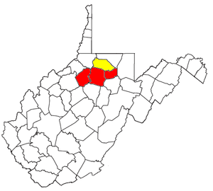
Clarksburg micropolitan area
Encyclopedia
United States Census Bureau
The United States Census Bureau is the government agency that is responsible for the United States Census. It also gathers other national demographic and economic data...
, is an area consisting of three counties in North-Central
North-Central West Virginia
North-Central West Virginia is a region of the U.S. State of West Virginia. The region's largest city is Morgantown.- Counties :*Monongalia County*Marion County*Harrison County*Taylor County*Doddridge County...
West Virginia
West Virginia
West Virginia is a state in the Appalachian and Southeastern regions of the United States, bordered by Virginia to the southeast, Kentucky to the southwest, Ohio to the northwest, Pennsylvania to the northeast and Maryland to the east...
, anchored by the city of Clarksburg
Clarksburg, West Virginia
Clarksburg is a city in and the county seat of Harrison County, West Virginia, United States, in the north-central region of the state. It is the principal city of the Clarksburg, WV Micropolitan Statistical Area...
.
As of the 2000 census
United States Census, 2000
The Twenty-second United States Census, known as Census 2000 and conducted by the Census Bureau, determined the resident population of the United States on April 1, 2000, to be 281,421,906, an increase of 13.2% over the 248,709,873 persons enumerated during the 1990 Census...
, the μSA had a population of 92,144 (though a July 1, 2009 estimate placed the population at 92,441).
Counties
- DoddridgeDoddridge County, West VirginiaAs of the census of 2000, there were 7,403 people, 2,845 households, and 2,102 families residing in the county. The population density was 23 people per square mile . There were 3,661 housing units at an average density of 11 per square mile...
- HarrisonHarrison County, West VirginiaAs of the census of 2000, there were 68,652 people, 27,867 households, and 19,088 families residing in the county. The population density was 165 people per square mile . There were 31,112 housing units at an average density of 75 per square mile...
- TaylorTaylor County, West VirginiaAs of the census of 2000, there were 16,089 people, 6,320 households, and 4,487 families residing in the county. The population density was 93 people per square mile . There were 7,125 housing units at an average density of 41 per square mile...
Communities
- Places with 10,000 or more inhabitants
- ClarksburgClarksburg, West VirginiaClarksburg is a city in and the county seat of Harrison County, West Virginia, United States, in the north-central region of the state. It is the principal city of the Clarksburg, WV Micropolitan Statistical Area...
(Principal city)
- Clarksburg
- Places with 5,000 to 10,000 inhabitants
- BridgeportBridgeport, West VirginiaBridgeport is a city in Harrison County, West Virginia, United States. The population was 7,306 at the 2000 census.The town of Bridgeport had its beginning in pre-Revolutionary War times. In 1764, John Simpson entered the area and gave his name to Simpson Creek. Bridgeport was chartered in 1816....
- GraftonGrafton, West VirginiaGrafton is a city in, and county seat of, Taylor County, West Virginia, USA. The population was 5,489 at the 2000 census. The only two national cemeteries in West Virginia are located in Grafton. Mother's Day was founded in Grafton on May 10, 1908; the city is the home to the International Mother's...
- Bridgeport
- Places with 1,000 to 5,000 inhabitants
- DespardDespard, West VirginiaDespard is a census-designated place in Harrison County, West Virginia, United States. The population was 1,004 at the 2010 census.-Geography:Despard is located at ....
- Nutter FortNutter Fort, West VirginiaNutter Fort is a town in Harrison County, West Virginia, United States, incorporated in 1923. The town is a southeastern suburb of Clarksburg, West Virginia. Since 1996, Nutter Fort has held the West Virginia Blackberry Festival during the first weekend of August. The population was 1,686 at the...
- SalemSalem, West VirginiaSalem is a city in Harrison County, West Virginia, United States. The population was 2,006 at the 2000 census. It is located at the junction of U.S. Route 50 and West Virginia Route 23; the North Bend Rail Trail passes through the city...
- ShinnstonShinnston, West VirginiaShinnston is a city in Harrison County, West Virginia, United States, along the West Fork River. The population was 2,295 at the 2000 census.-Geography:Shinnston is located at ....
- StonewoodStonewood, West VirginiaStonewood is a city in Harrison County, West Virginia, United States. The population was 1,815 at the 2000 census.-Geography:Stonewood is located at , along Elk Creek....
- Despard
- Places with less than 1,000 inhabitants
- AnmooreAnmoore, West VirginiaAnmoore is a town in Harrison County, West Virginia, United States. Located at the intersection of WV Rt 58 and Interstate 79. The population was 685 at the 2000 census.-Geography:Anmoore is located at ....
- EnterpriseEnterprise, West VirginiaEnterprise is a census-designated place in Harrison County, West Virginia, United States, along the West Fork River. The population was 961 at the 2010 census.-Geography:Enterprise is located at ....
- FlemingtonFlemington, West VirginiaFlemington is a town in Taylor County, West Virginia, United States. The population was 287 at the 2000 census. Flemington was incorporated in 1922 by Circuit Court, and named for James Fleming, an early settler in the area originally from Hampshire County....
- Lost CreekLost Creek, West VirginiaLost Creek is a town in Harrison County, West Virginia, United States. The population was 467 at the 2000 census.-History:The Daniel Bassel House and Lost Creek Baltimore and Ohio Railroad Depot are listed on the National Register of Historic Places....
- LumberportLumberport, West VirginiaLumberport is a town in Harrison County, West Virginia, United States. The population was 937 at the 2000 census.-Geography:Lumberport is located at , at the confluence of Tenmile Creek and the West Fork River....
- West MilfordWest Milford, West VirginiaWest Milford is a town in Harrison County, West Virginia, United States. The population was 651 at the 2000 census.-Geography:West Milford is located at , along the West Fork River....
- West UnionWest Union, West VirginiaWest Union, incorporated July 20, 1881, is a town in Doddridge County, West Virginia. The population was 806 at the 2000 census. It is the county seat of Doddridge County. The mayor is Robert Fetty as of 2011. The town is located along Middle Island Creek at the junction of U.S...
- Anmoore
- Unincorporated places
- Astor
- BelgiumBelgium, West VirginiaBelgium is an unincorporated community in Taylor County, West Virginia, United States....
- Blueville
- Brownlow
- Center PointCenter Point, West VirginiaCenter Point is an unincorporated community in northeastern Doddridge County, West Virginia, United States. It lies along Route 23 northeast of the town of West Union, the county seat of Doddridge County. Its elevation is 791 feet...
- Elliotsville
- FettermanFetterman, West VirginiaFetterman is a community or populated place located in Taylor County, West Virginia. The elevation is . Fetterman appears on the Grafton U.S. Geological Survey Map. Taylor County is in the Eastern time zone and in postal zip code 26354. Fetterman was one of the early settlements in what became...
- HepzibahHepzibah, Taylor County, West VirginiaHepzibah is an unincorporated community in Taylor County, West Virginia, United States. Hepzibah is northeast of Bridgeport....
- Knottsville
-
- Lucretia
- McGee
- Meadland
- Millertown
- New MiltonNew Milton, West VirginiaNew Milton is an unincorporated community in central Doddridge County, West Virginia, United States. It lies southeast of the town of West Union, the county seat of Doddridge County. Its elevation is 833 feet . Although it is unincorporated, it has a post office, with the ZIP code of 26411....
- Oreide
- Park View
- PruntytownPruntytown, West VirginiaPruntytown is an unincorporated town at the junction of the Northwestern Turnpike and U.S. Route 250 in Taylor County, West Virginia. It is the site of the Pruntytown Correctional Center, formerly known as the West Virginia Industrial School for Boys.- External links :**...
- RosemontRosemont, West VirginiaRosemont is an unincorporated community in Taylor County, West Virginia, United States. Rosemont is located on West Virginia Route 76 east-southeast of Bridgeport. Rosemont has a post office with ZIP code 26424....
-
- Santiago
- SimpsonSimpson, West VirginiaSimpson is an unincorporated town in Taylor County, West Virginia. It is the hometown of Randal McCloy, sole survivor of the 2006 Sago Mine disaster at Sago in Upshur County....
- SmithburgSmithburg, West VirginiaSmithburg is an unincorporated community in Doddridge County in the U.S. state of West Virginia. It is located along U.S. Route 50. Middle Island Creek, the longest river to be called a creek, is formed in Smithburg by the confluence of Meathouse Fork and Buckeye Creek. The North Bend Rail Trail...
- South Grafton
- Tappan
- ThorntonThornton, West VirginiaThornton is an unincorporated town in Taylor County, West Virginia. Thornton is located on Three Fork Creek along the Northwestern Turnpike at its junction with County Route 7. Thornton also hosts an annual Pumpkin Festival...
- WebsterWebster, West VirginiaWebster is an unincorporated community in Taylor County, West Virginia, United States. It lies four miles south of Grafton. Its elevation is 1,019 feet above sea level.- History :...
- Wendel
- West Grafton
Demographics
As of the censusCensus
A census is the procedure of systematically acquiring and recording information about the members of a given population. It is a regularly occurring and official count of a particular population. The term is used mostly in connection with national population and housing censuses; other common...
of 2000, there were 92,144 people, 37,032 households, and 25,677 families residing within the μSA. The racial makeup of the μSA was 96.96% White, 1.37% African American, 0.17% Native American, 0.48% Asian, 0.03% Pacific Islander, 0.18% from other races
Race (United States Census)
Race and ethnicity in the United States Census, as defined by the Federal Office of Management and Budget and the United States Census Bureau, are self-identification data items in which residents choose the race or races with which they most closely identify, and indicate whether or not they are...
, and 0.82% from two or more races. Hispanic or Latino of any race were 0.86% of the population.
The median income for a household in the μSA was $28,143, and the median income for a family was $33,198. Males had a median income of $28,991 versus $20,825 for females. The per capita income
Per capita income
Per capita income or income per person is a measure of mean income within an economic aggregate, such as a country or city. It is calculated by taking a measure of all sources of income in the aggregate and dividing it by the total population...
for the μSA was $14,666.
Combined Statistical Area
The Clarksburg μSA is combined with the Fairmont μSAMarion County, West Virginia
| style="float:right;"|As of the census of 2000, there were 56,598 people, 23,652 households, and 15,515 families residing in the county. The population density was 183 people per square mile . There were 26,660 housing units at an average density of 86 per square mile...
to form the Fairmont-Clarksburg Combined Statistical Area
Combined Statistical Area
The United States Office of Management and Budget defines micropolitan and metropolitan statistical areas. Metropolitan and micropolitan statistical areas consist of one or more counties...
(CSA), which had a population of 148,742 at the 2000 census
United States Census, 2000
The Twenty-second United States Census, known as Census 2000 and conducted by the Census Bureau, determined the resident population of the United States on April 1, 2000, to be 281,421,906, an increase of 13.2% over the 248,709,873 persons enumerated during the 1990 Census...
. In addition to the three counties of the Clarksburg μSA, the CSA comprises the city of Fairmont
Fairmont, West Virginia
Fairmont is a city in Marion County, West Virginia, United States. Nicknamed "The Friendly City". The population was 18,704 at the 2010 census...
(2000 population 19,097) and the rest of Marion County
Marion County, West Virginia
| style="float:right;"|As of the census of 2000, there were 56,598 people, 23,652 households, and 15,515 families residing in the county. The population density was 183 people per square mile . There were 26,660 housing units at an average density of 86 per square mile...
, which lies immediately to the north of the counties of the Clarksburg μSA.