

Cilymaenllwyd
Encyclopedia
Civil parish
In England, a civil parish is a territorial designation and, where they are found, the lowest tier of local government below districts and counties...
on the extreme northwest of Carmarthenshire
Carmarthenshire
Carmarthenshire is a unitary authority in the south west of Wales and one of thirteen historic counties. It is the 3rd largest in Wales. Its three largest towns are Llanelli, Carmarthen and Ammanford...
in West Wales
West Wales
West Wales is the western area of Wales.Some definitions of West Wales include only Pembrokeshire, Ceredigion and Carmarthenshire, an area which historically comprised the Welsh principality of Deheubarth., an area called "South West Wales" in the Nomenclature of Territorial Units for Statistics....
. It lies about 40 km west of Carmarthen
Carmarthen
Carmarthen is a community in, and the county town of, Carmarthenshire, Wales. It is sited on the River Towy north of its mouth at Carmarthen Bay. In 2001, the population was 14,648....
, 20 km southeast of Fishguard
Fishguard
Fishguard is a coastal town in Pembrokeshire, south-west Wales, with a population of 3,300 . The community of Fishguard and Goodwick had a population of 5043 at the 2001 census....
and 30 km northwest of Haverfordwest
Haverfordwest
Haverfordwest is the county town of Pembrokeshire, Wales and serves as the County's principal commercial and administrative centre. Haverfordwest is the most populous urban area in Pembrokeshire, with a population of 13,367 in 2001; though its community boundaries make it the second most populous...
.
History & Amenities
Cilymaenllwyd has an area of 2628 hectareHectare
The hectare is a metric unit of area defined as 10,000 square metres , and primarily used in the measurement of land. In 1795, when the metric system was introduced, the are was defined as being 100 square metres and the hectare was thus 100 ares or 1/100 km2...
s and a population
Population
A population is all the organisms that both belong to the same group or species and live in the same geographical area. The area that is used to define a sexual population is such that inter-breeding is possible between any pair within the area and more probable than cross-breeding with individuals...
of 725. The western edge of the community borders Pembrokeshire
Pembrokeshire
Pembrokeshire is a county in the south west of Wales. It borders Carmarthenshire to the east and Ceredigion to the north east. The county town is Haverfordwest where Pembrokeshire County Council is headquartered....
. The Pembrokeshire River Tâf
River Tâf
The River Tâf is a river that rises in the Preseli Hills of North Pembrokeshire, West Wales, near the village of Crymych and is around 50 km long....
forms the eastern boundary. The area is a plateau being part of the foothills of the Preseli Mountains rising to an altitude of 248 metres. But it is dissected by deep valleys of the Tâf and tributaries. The principal commerce of the parish
Parish
A parish is a territorial unit historically under the pastoral care and clerical jurisdiction of one parish priest, who might be assisted in his pastoral duties by a curate or curates - also priests but not the parish priest - from a more or less central parish church with its associated organization...
is agriculture
Agriculture
Agriculture is the cultivation of animals, plants, fungi and other life forms for food, fiber, and other products used to sustain life. Agriculture was the key implement in the rise of sedentary human civilization, whereby farming of domesticated species created food surpluses that nurtured the...
. On 13 May 1839, the tollgate at Efailwen, within Cilymaenllwyd, was the first turnpike to be attacked in what would later become the Rebecca Riots
Rebecca Riots
The Rebecca Riots took place between 1839 and 1843 in South and Mid Wales. They were a series of protests undertaken by local farmers and agricultural workers in response to perceived unfair taxation. The rioters, often men dressed as women, took their actions against toll-gates, as they were...
, an uprising by poor farmers to abolish what they believed were unfair taxations.
Historically it was part of Derllys Hundred. Very few maps mark the name Cilymaenllwyd but place names which do appear are:
| grid ref British national grid reference system The Ordnance Survey National Grid reference system is a system of geographic grid references used in Great Britain, different from using latitude and longitude.... |
|
| Efailwen | |
| Glandy Cross | |
| Login | |
| Pant-y-Caws |
Worship
Places of worship in the community are:| grid ref British national grid reference system The Ordnance Survey National Grid reference system is a system of geographic grid references used in Great Britain, different from using latitude and longitude.... |
Erected | |
| ? | Parish church, now used as a clothing factory | |
| 1828 | Calfaria Particular Baptist Chapel, Login | |
| 1836 | Nebo Independent Congregational church Congregational churches are Protestant Christian churches practicing Congregationalist church governance, in which each congregation independently and autonomously runs its own affairs.... Chapel, Efailwen / Eglwyswen |
|
| 1858 | Cwm-miles Independent Chapel, Cwm-miles |
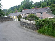
Login
The hamletHamlet (place)
A hamlet is usually a rural settlement which is too small to be considered a village, though sometimes the word is used for a different sort of community. Historically, when a hamlet became large enough to justify building a church, it was then classified as a village...
of Login lies in the valley and sits on both sides of the River Tâf. The name Login may have come from the old Welsh language
Welsh language
Welsh is a member of the Brythonic branch of the Celtic languages spoken natively in Wales, by some along the Welsh border in England, and in Y Wladfa...
word halogyn meaning a dirty pool or stream. The Whitland & Cardigan Railway
Whitland & Cardigan Railway
The Whitland & Cardigan Railway was a fourteen and a half mile long Great Western Railway built branch railway line that ran between on the West Wales Line to via nine intermediate stations, , , , , , , , , and .-History:...
came up the valley and there was a station in Login.