

Chimney Bluffs State Park
Encyclopedia
State park
State parks are parks or other protected areas managed at the federated state level within those nations which use "state" as a political subdivision. State parks are typically established by a state to preserve a location on account of its natural beauty, historic interest, or recreational...
in the town of Huron
Huron, New York
Huron is a town in Wayne County, New York, United States. The population was 2,117 at the 2000 census. The town is named after the Huron Indians.The Town of Huron is in the northeastern part of the county and is east of Rochester, NY.- History :...
in Wayne County, New York
Wayne County, New York
Wayne County is a county located in the US state of New York. It is part of the Rochester, New York Metropolitan Statistical Area and lies on the south shore of Lake Ontario, forming part of the northern border of the United States with Canada. The name honors General Anthony Wayne, an American...
on Lake Ontario
Lake Ontario
Lake Ontario is one of the five Great Lakes of North America. It is bounded on the north and southwest by the Canadian province of Ontario, and on the south by the American state of New York. Ontario, Canada's most populous province, was named for the lake. In the Wyandot language, ontarío means...
, on the eastern shore of Sodus Bay
Sodus Bay
Sodus Bay is a bay on the south shore of Lake Ontario, one of the Great Lakes. Sodus Bay is located in Wayne County, New York, USA. Most of the bay is in the Town of Huron, but the western part is in the Town of Sodus....
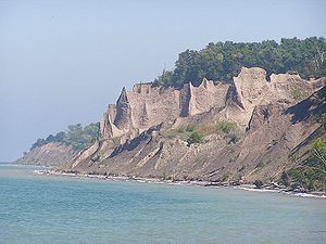
. Using its hiking trails, the intrepid visitor can enjoy unique views of large clay rock formation
Rock formations in the United States
The following is a partial list of rock formations in the United States, by state:-Arizona:*Canyon de Chelly National Monument**Spider Rock*Chiricahua National Monument**Duck on a Rock**Organ Pipe**Mushroom Rock**Sea Captain*Monument Valley...
s at the water’s edge.
The park has approximately four miles of hiking trails, including a mile-long trail along the Bluffs from the West entrance to the East entrance.
Geology
The Bluffs were formed from drumlins, which in turn were created by glaciers in the last ice ageIce age
An ice age or, more precisely, glacial age, is a generic geological period of long-term reduction in the temperature of the Earth's surface and atmosphere, resulting in the presence or expansion of continental ice sheets, polar ice sheets and alpine glaciers...
. The erosive power of wind, rain, snow, and waves—both from above and below—has formed the landscape into razor-sharp pinnacles. Although the impressive pinnacles and cliffs, some of which rise up to 150 feet from the lake shore, have existed throughout recorded history, they present a changing panorama: the average erosion of bluffs is 1 to 5 feet per year.
The Lake Ontario shoreline from Sodus Bay to Oswego
Oswego, New York
Oswego is a city in Oswego County, New York, United States. The population was 18,142 at the 2010 census. Oswego is located on Lake Ontario in north-central New York and promotes itself as "The Port City of Central New York"...
has many bluffs, of which Chimney Bluffs is the most visited.
From some vantage points in the State Park, visitors can see Nine Mile Point nuclear power station, 25 miles to the northeast and the coal smokestacks located in Oswego.
Park history
The Chimney Bluffs area has been a landmark for many years. According to the pamphlet given by the park, smugglers used the area as a landing point while transporting liquor from CanadaCanada
Canada is a North American country consisting of ten provinces and three territories. Located in the northern part of the continent, it extends from the Atlantic Ocean in the east to the Pacific Ocean in the west, and northward into the Arctic Ocean...
during Prohibition
Prohibition
Prohibition of alcohol, often referred to simply as prohibition, is the practice of prohibiting the manufacture, transportation, import, export, sale, and consumption of alcohol and alcoholic beverages. The term can also apply to the periods in the histories of the countries during which the...
. Operated informally as a privately owned recreation area for years, the area was acquired by the state of New York in 1963 and soon named a state park.
It lay undeveloped until 1999 when a parking lot, service building with heated restrooms, picnic areas with grills, and hiking trails throughout the park were added. It is considered a year round park for hikers, biking and picnicking in the summer. Winter activities include cross country skiing, snow shoeing, and there is a trailhead for snowmobiling.