
Chicago Metropolitan Agency for Planning
Encyclopedia
The Chicago Metropolitan Agency for Planning (CMAP) is an agency that integrates land use planning
and transportation planning
for the counties of Cook
, DuPage
, Kane
, Kendall
, Lake
, McHenry
and Will
in northeastern Illinois
. CMAP and its partners aim to remove barriers to cooperation across geographical boundaries and subject areas such as land use, transportation, natural resources, housing, and economic development.
CMAP's goal is to coordinate the efforts of the multitude of local governmental agencies and supply them with the best technical assistance and analysis to improve land use and transportation decision-making for the region. On October 13, 2010, CMAP's governing boards unanimously adopted GO TO 2040, the region's first comprehensive plan since Daniel Burnham's 1909 Plan of Chicago.
for the Chicago region, responsible for regional transportation planning. NIPC was the comprehensive planning
agency for the six county region. Kendall County was not part of the NIPC jurisdiction, but now falls under CMAP's jurisdiction.
legislation, CMAP is responsible for developing the region's official transportation plan, part of the broader GO TO 2040 comprehensive plan that integrates transportation with land use, housing, economic development, open space, the environment, and other quality-of-life issues. This transportation plan must be updated every four years, use visualization techniques, engage the general public, and include a separate Transportation Improvement Program document.
devices to record and transmit parcel-by-parcel data to a central server. Participants are able to view the changes they make immediately online and develop detailed maps of their neighborhood based on the data they collect. In addition, CMAP assists local governments with issues such as economic development
, plan-making, data
development and analysis, green
initiatives, and more. Examples include help with address-canvassing required by the US Census Bureau
and assistance with lake restoration and protection (see the Volunteer Lake Monitoring Program coordinated by the IL EPA). CMAP also facilitates public discussions (and occasionally takes public positions) on important regional issues such as the proposed capital plan and EJ&E acquisition.
Land use planning
Land-use planning is the term used for a branch of public policy encompassing various disciplines which seek to order and regulate land use in an efficient and ethical way, thus preventing land-use conflicts. Governments use land-use planning to manage the development of land within their...
and transportation planning
Transportation planning
Transportation planning is a field involved with the evaluation, assessment, design and siting of transportation facilities .-Models and Sustainability :...
for the counties of Cook
Cook County, Illinois
Cook County is a county in the U.S. state of Illinois, with its county seat in Chicago. It is the second most populous county in the United States after Los Angeles County. The county has 5,194,675 residents, which is 40.5 percent of all Illinois residents. Cook County's population is larger than...
, DuPage
DuPage County, Illinois
As of the 2010 Census, the population of the county was 916,924, White Americans made up 77.9% of Dupage County's population; non-Hispanic whites represented 70.5% of the population. Black Americans made up 4.6% of the population. Native Americans made up 0.3% of Dupage County's population...
, Kane
Kane County, Illinois
Kane County is a county located in the U.S. state of Illinois. According to the 2010 census, it has a population of 515,269, which is an increase of 27.5% from 404,119 in 2000. Its county seat is Geneva, and its largest city is Aurora.- Geography :...
, Kendall
Kendall County, Illinois
Kendall County is a county located in the U.S. state of Illinois, about 40 miles southwest of Chicago. According to the 2010 census, it has a population of 114,736, which is an increase of 110% from 54,544 in 2000. It was the fastest-growing county in the United States between the years 2000 and...
, Lake
Lake County, Illinois
Lake County is a county in the northeastern corner of the state of Illinois, on the shore of Lake Michigan. According to the 2010 census, it has a population of 703,462, which is an increase of 9.2% from 644,356 in 2000. Its county seat is Waukegan. The county is part of the Chicago metropolitan area...
, McHenry
McHenry County, Illinois
McHenry County is a county located in the U.S. state of Illinois. According to the 2010 census, it has a population of 308,760, which is an increase of 18.7% from 260,077 in 2000. Its county seat is Woodstock. This county is part of the Chicago metropolitan area. It is the sixth largest county, in...
and Will
Will County, Illinois
As of the census of 2000, there were 502,266 people, 167,542 households, and 131,017 families residing in the county. The population density was 600 people per square mile . There were 175,524 housing units at an average density of 210 per square mile...
in northeastern Illinois
Illinois
Illinois is the fifth-most populous state of the United States of America, and is often noted for being a microcosm of the entire country. With Chicago in the northeast, small industrial cities and great agricultural productivity in central and northern Illinois, and natural resources like coal,...
. CMAP and its partners aim to remove barriers to cooperation across geographical boundaries and subject areas such as land use, transportation, natural resources, housing, and economic development.
CMAP's goal is to coordinate the efforts of the multitude of local governmental agencies and supply them with the best technical assistance and analysis to improve land use and transportation decision-making for the region. On October 13, 2010, CMAP's governing boards unanimously adopted GO TO 2040, the region's first comprehensive plan since Daniel Burnham's 1909 Plan of Chicago.
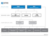
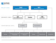
History
In the summer of 2005, Public Act 094-0510 called for the merger of the Chicago Area Transportation Study (CATS) and the Northeastern Illinois Planning Commission (NIPC). CATS was the federally designated Metropolitan Planning OrganizationMetropolitan planning organization
A metropolitan planning organization is a federally-mandated and federally-funded transportation policy-making organization in the United States that is made up of representatives from local government and governmental transportation authorities...
for the Chicago region, responsible for regional transportation planning. NIPC was the comprehensive planning
Comprehensive planning
Comprehensive planning is a term used in the United States by land use planners to describe a process that determines community goals and aspirations in terms of community development. The outcome of comprehensive planning is the Comprehensive Plan which dictates public policy in terms of...
agency for the six county region. Kendall County was not part of the NIPC jurisdiction, but now falls under CMAP's jurisdiction.
Responsibilities
The State of Illinois legislation that created CMAP gave the agency the task of integrating the previously separate topics of land use and transportation into one agency that would protect natural resources, improve mobility, and minimize traffic congestion in the seven-county region. Under SAFETEA-LUSafe, Accountable, Flexible, Efficient Transportation Equity Act: A Legacy for Users
The Safe, Accountable, Flexible, Efficient Transportation Equity Act: A Legacy for Users is a funding and authorization bill that governs United States federal surface transportation spending. It was signed into law by President George W. Bush on August 10, 2005, and expired as of September 30, 2009...
legislation, CMAP is responsible for developing the region's official transportation plan, part of the broader GO TO 2040 comprehensive plan that integrates transportation with land use, housing, economic development, open space, the environment, and other quality-of-life issues. This transportation plan must be updated every four years, use visualization techniques, engage the general public, and include a separate Transportation Improvement Program document.
Current Projects
The agency's primary objective is now to lead implementation of the GO TO 2040 comprehensive regional plan. On October 14, 2010, the U.S. Department of Housing and Urban Development (HUD) Sustainable Communities Initiative announced a three-year, $4.25 million award to CMAP for technical assistance to communities seeking to implement GO TO 2040. CMAP's work plan includes projects that span the divide between addressing neighborhood planning issues and creating wide reaching policy initiatives and legislation. One example of how CMAP assists small organizations is the Full Circle program, whereby community volunteers use hand-held wirelessWireless
Wireless telecommunications is the transfer of information between two or more points that are not physically connected. Distances can be short, such as a few meters for television remote control, or as far as thousands or even millions of kilometers for deep-space radio communications...
devices to record and transmit parcel-by-parcel data to a central server. Participants are able to view the changes they make immediately online and develop detailed maps of their neighborhood based on the data they collect. In addition, CMAP assists local governments with issues such as economic development
Economic development
Economic development generally refers to the sustained, concerted actions of policymakers and communities that promote the standard of living and economic health of a specific area...
, plan-making, data
Data
The term data refers to qualitative or quantitative attributes of a variable or set of variables. Data are typically the results of measurements and can be the basis of graphs, images, or observations of a set of variables. Data are often viewed as the lowest level of abstraction from which...
development and analysis, green
Environmental technology
Environmental technology or green technology or clean technology is the application of one or more of environmental science, green chemistry, environmental monitoring and electronic devices to monitor, model and conserve the natural environment and resources, and to curb the negative impacts of...
initiatives, and more. Examples include help with address-canvassing required by the US Census Bureau
United States Census Bureau
The United States Census Bureau is the government agency that is responsible for the United States Census. It also gathers other national demographic and economic data...
and assistance with lake restoration and protection (see the Volunteer Lake Monitoring Program coordinated by the IL EPA). CMAP also facilitates public discussions (and occasionally takes public positions) on important regional issues such as the proposed capital plan and EJ&E acquisition.