ABSOLUTEASTRONOMY
Create a free discussion account!
Signup
Login
x
Home
Search
Topics
Almanac
Science
Nature
People
History
Society
Signup
Login
ABSOLUTEASTRONOMY
HOME
TOPICS
ALMANAC
SCIENCE
NATURE
PEOPLE
HISTORY
SOCIETY
PHILOSOPHY
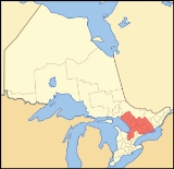
Central Ontario
Topic Home
Discussion
0
Encyclopedia
The source of this article is
wikipedia
, the free encyclopedia. The text of this article is licensed under the
GFDL
.
x
OK