

Central Aroostook, Maine
Encyclopedia
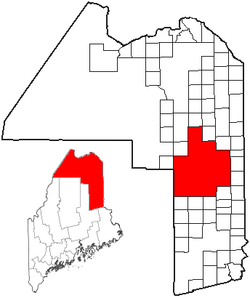
Unorganized territory
An unorganized territory is a region of land without a "normally" constituted system of government. This does not mean that the territory has no government at all or that it is unclaimed territory...
in Aroostook County
Aroostook County, Maine
Aroostook County is a county located in the U.S. state of Maine. In 2010, its population was 71,870. In land area, it is the largest county in the state and the largest U.S. county east of the Mississippi River. Its seat is Houlton...
, Maine
Maine
Maine is a state in the New England region of the northeastern United States, bordered by the Atlantic Ocean to the east and south, New Hampshire to the west, and the Canadian provinces of Quebec to the northwest and New Brunswick to the northeast. Maine is both the northernmost and easternmost...
, United States
United States
The United States of America is a federal constitutional republic comprising fifty states and a federal district...
. The population was 95 at the 2000 census.
Geography
According to the United States Census BureauUnited States Census Bureau
The United States Census Bureau is the government agency that is responsible for the United States Census. It also gathers other national demographic and economic data...
, the unorganized territory has a total area of 566.5 square miles (1,467.2 km²), of which, 556.0 square miles (1,440.1 km²) of it is land and 10.4 square miles (27.1 km²) of it (1.84%) is water.
There are fifteen townships in the unorganized territory, including Webbertown, St. Croix, Squapan, Swett Farm, Dudley, and E Township
E Township, Maine
E is an unincorporated township located in Aroostook County, Maine, United States. It is part of the Central Aroostook Unorganized Territory and borders the towns of Blaine to the east and Westfield to the north. As of the 1990 census, when it was still organized as a plantation, E Plantation...
. Cox Patent, an area within the township of TDR2 WELS, is also in Central Aroostook.
Demographics
As of the censusCensus
A census is the procedure of systematically acquiring and recording information about the members of a given population. It is a regularly occurring and official count of a particular population. The term is used mostly in connection with national population and housing censuses; other common...
of 2000, there were 95 people, 44 households, and 27 families residing in the unorganized territory. The population density
Population density
Population density is a measurement of population per unit area or unit volume. It is frequently applied to living organisms, and particularly to humans...
was 0.2 people per square mile (0.1/km²). There were 347 housing units at an average density of 0.6/sq mi (0.2/km²). The racial makeup of the unorganized territory was 98.95% White, and 1.05% from two or more races.
There were 44 households out of which 11.4% had children under the age of 18 living with them, 63.6% were married couples
Marriage
Marriage is a social union or legal contract between people that creates kinship. It is an institution in which interpersonal relationships, usually intimate and sexual, are acknowledged in a variety of ways, depending on the culture or subculture in which it is found...
living together, and 36.4% were non-families. 31.8% of all households were made up of individuals and 20.5% had someone living alone who was 65 years of age or older. The average household size was 2.16 and the average family size was 2.61.
In the unorganized territory the population was spread out with 11.6% under the age of 18, 4.2% from 18 to 24, 17.9% from 25 to 44, 43.2% from 45 to 64, and 23.2% who were 65 years of age or older. The median age was 49 years. For every 100 females there were 120.9 males. For every 100 females age 18 and over, there were 115.4 males.
The median income for a household in the unorganized territory was $20,313, and the median income for a family was $22,188. Males had a median income of $21,875 versus $19,375 for females. The per capita income
Per capita income
Per capita income or income per person is a measure of mean income within an economic aggregate, such as a country or city. It is calculated by taking a measure of all sources of income in the aggregate and dividing it by the total population...
for the unorganized territory was $14,680. There were 30.3% of families and 38.6% of the population living below the poverty line, including 75.0% of under eighteens and 10.5% of those over 64.