

Cefn Cyfarwydd
Encyclopedia
Wales
Wales is a country that is part of the United Kingdom and the island of Great Britain, bordered by England to its east and the Atlantic Ocean and Irish Sea to its west. It has a population of three million, and a total area of 20,779 km²...
. It is located above the village of Trefriw
Trefriw
Trefriw is a village in Conwy County Borough, Wales. It lies on the river Conwy in North Wales, a few miles south of the site of the Roman fort of Canovium, sited at Caerhun. The parish population in 2001 was 924....
on the western side of the Conwy valley, and dramatically separates the rugged mountains of the Carneddau
Carneddau
The Carneddau , are a group of mountains in Snowdonia, Wales. It includes the largest contiguous areas of high ground in Wales and England, as well as six or seven of the highest peaks in the country—the Fourteen Peaks...
from the greener, lusher Conwy valley.
The Welsh
Welsh language
Welsh is a member of the Brythonic branch of the Celtic languages spoken natively in Wales, by some along the Welsh border in England, and in Y Wladfa...
word cyfarwydd can mean either "familiar" (adj.) or "a story-teller, guide or expert" (noun). Cefn means "ridge".
'Cefn Cyfarwydd' therefore translates as either "familiar ridge" or "story-teller's ridge".
Extent
The ridge reaches some 500m in height, and covers an area of some 8 square kilometres, broadly 4 km long by 2 km wide. It runs in a largely SW - NE direction, and is relatively flat-topped, resulting in some wet pools and boggy patches, even in the summer months. Much of it is heatheryCalluna
Calluna vulgaris is the sole species in the genus Calluna in the family Ericaceae. It is a low-growing perennial shrub growing to tall, or rarely to and taller, and is found widely in Europe and Asia Minor on acidic soils in open sunny situations and in moderate shade...
moorland.
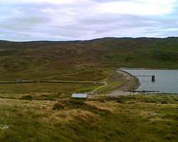
To the north-west it slopes down steeply to Llyn Cowlyd
Llyn Cowlyd
Llyn Cowlyd is the deepest lake in North Wales. It lies in the Snowdonia National Park on the edge of the Carneddau range of mountains, at a height of above sea level. The lake is long and narrow, measuring nearly long and about a third of a mile wide, and covers an area of...
, and to the south-east to Llyn Crafnant
Llyn Crafnant
Llyn Crafnant is a lake that lies in a beautiful valley in North Wales where the northern edge of the Gwydir Forest meets the lower slopes of the Carneddau mountains and, more specifically, the ridge of Cefn Cyfarwydd. The head of the valley offers a profile of crags which are silhouetted at...
and the Crafnant valley where, in places, these slopes have been forested. The south-eastern slope of the ridge is steeper than the north-western slope.
The north-eastern end of the ridge drops into the Conwy valley between Trefriw and Dolgarrog
Dolgarrog
Dolgarrog is a small village in the Conwy County Borough in North Wales situated between Llanrwst and Conwy, very close to the Conwy River. The village is well known for its industrial history since the 18th century and the Eigiau dam disaster, which occurred in 1925...
, whilst to the south-west it runs on to become Pen y Graig Gron ("top/end of the round stone"), then rises to the ridge of Creigiau Gleision
Creigiau Gleision
Creigiau Gleision is a mountain in Snowdonia, Wales, near Capel Curig. It is the easternmost of the high Carneddau and is separated from the others by Llyn Cowlyd. Directly across this reservoir from Creigiau Gleision is Pen Llithrig y Wrach...
("blue-green rocks") (over 600m in height) and the Crimpiau. For much of its length it affords splendid views in all directions.
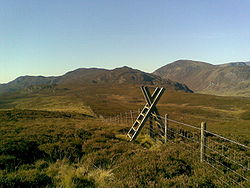
Height
There is a trig pointTrig point
A triangulation station, also known as a triangulation pillar, trigonometrical station, trigonometrical point, trig station, trig beacon or trig point, and sometimes informally as a trig, is a fixed surveying station, used in geodetic surveying and other surveying projects in its vicinity...
(triangulation pillar TP2074) recording a height of 419m (1375ft) at location SH7641664273 http://www.streetmap.co.uk/newmap.srf?x=276417&y=364268&z=3&dn=598&tl=TP2074+-+Cefn+Cyfarwydd. This can be easily viewed from Ffordd Cowlyd, the lane from Trefriw to Llyn Cowlyd, which crosses Cefn Cyfarwydd towards its northern end.
The trig point is, however, not at the highest point of the ridge. The highest point actually lies some mile to the south-west, where a cairn has been placed at a height of 503m (1650ft). http://www.streetmap.co.uk/newmap.srf?x=275175&y=363100&z=3&sv=275175,363100&st=4&ar=Y&dn=598 This is just a little north of the remains of Lledwigan burial cairn, which probably dates to the Bronze Age.http://www.coflein.gov.uk/en/site/303104/details/LLEDWIGAN+CAIRN%3B+CEFN+CYFARWYDD+CAIRN
Access
The top of the ridge is remote and wild, in direct contrast to the Conwy valley to the east.Whilst remote, it can be accessed by a number of rights of way -
- from the southern end of Llyn Crafnant (on the path to Capel Curig) via the Crimpiau
- from the southern end of Llyn Crafnant, via the forested slopes
- from half way down the Crafnant valley, skirting Lledwigan Farm
- from Ffordd Cowlyd (the road from Trefriw) which crosses its northern end, near to the triangulation point (at 419m) http://geodaisy.com/place/tp2074.html.
- from Llyn Cowlyd dam up to the top of the ridge
- from Capel Curig, via The Crimpiau or Creigiau Gleision
Whilst it is possible to traverse the entire length of the ridge, the north-eastern half is lacking in good paths through the heather, gorse and bilberry, and boggy patches abound. Sheep tracks criss-cross in all directions, and some are used by farmers' quad bikes which makes them the best option, but they are hard to find, even in good conditions. It is easier to find a good path when traversing from south to north (i.e. towards the Trefriw road), as paths can be seen when looking down from above.
Old Settlement
The ridge contains the evidence of many remains of old settlement. The Royal Commission on the Ancient and Historical Monuments of Wales http://www.rcahmw.gov.uk/uplands-10years/page69.shtml reports that a survey in 1993-4 added around 600 sites to the 2 already recorded on the Sites and Monuments Record. According to this record, the earliest evidence of activity was 4 cairns, probably dating back to the Bronze AgeBronze Age
The Bronze Age is a period characterized by the use of copper and its alloy bronze as the chief hard materials in the manufacture of some implements and weapons. Chronologically, it stands between the Stone Age and Iron Age...
, and there was a round hut
Round House
The Round House is the oldest building still standing in Western Australia. It is located at Arthur Head in Fremantle, and recent heritage assessments and appraisals of the precinct of the Round House incorporate Arthur Head....
with adjoining sub-rectangular structures suggesting late prehistoric settlement.
Many remains indicated mediaeval occupation, but these were not on the exposed top of the ridge, but generally between the 250m and 350m contours, where the soil was better and there was more shelter.
Most of the later sites have agricultural connections, and in some places traces of earlier field patterns survive. The most substantial remains today are derelict farmhouses, and even two two derelict chapels.
It is possible that some of the buildings on the edges of the marginal land may be hafotai (summer dwellings) rather than permanent dwellings.
Industry
The ridge also shows evidence of peat cutting, and there are the remains of several mine trials and small-scale quarrying, such as what is known today as Cefn Cyfarwydd slate mine.A Changing View
The view from Cefn Cyfarwydd has always changed, from the construction of Cowlyd Dam, to the pylons which have appeared further down the Conwy Valley, and as the town of LlanrwstLlanrwst
Llanrwst is a small town and community on the A470 road and the River Conwy in Conwy County Borough, Wales. It takes its name from the 5th century to 6th century Saint Grwst, and the original parish church in Cae Llan was replaced by the 12th-century church....
has grown. The 21st century has seen the development of 12 turbines at the Moel Maelogan
Moel Maelogan
thumb|300px|right|The first 3 turbines at Moel MaeloganMoel Maelogan is a hill on the western edge of Mynydd Hiraethog in north Wales, and overlooking the Conwy Valley...
wind farm
Wind farm
A wind farm is a group of wind turbines in the same location used to produce electric power. A large wind farm may consist of several hundred individual wind turbines, and cover an extended area of hundreds of square miles, but the land between the turbines may be used for agricultural or other...
on the other side of the Conwy Valley, and very visible from this ridge.