
Cedar Hills, Oregon
Encyclopedia
Cedar Hills is a census-designated place
and neighborhood in Washington County, Oregon
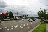
, near the intersection of highways Oregon Route 217 and U.S. 26. Cedar Hills was the largest single housing tract development in the western United States at the time of its creation in 1961.
Originally located in unincorporated Washington County, part of the neighborhood has since been annexed by the city of Beaverton
, and in a plan agreed to by the county and Beaverton the remainder is scheduled for annexation by 2010. This plan is widely opposed by residents of the Cedar Hills neighborhood.
Some of the property within the Cedar Hills neighborhood is subject to the rules and covenants enforced by the Homes Association of Cedar Hills.
The population was 8,949 at the 2000 census.
According to the United States Census Bureau
, the neighborhood has a total area of 2.3 square miles (6 km²), of which, 2.3 square miles (6 km²) of it is land and 0.43% is water.
of 2000, there were 8,949 people, 3,749 households, and 2,361 families residing in the neighborhood. The population density
was 3,880.9 people per square mile (1,495.8/km²). There were 3,926 housing units at an average density of 1,702.6 per square mile (656.2/km²). The racial makeup of the CDP was 83.28% White, 1.32% African American, 0.57% Native American, 4.78% Asian, 0.35% Pacific Islander, 6.05% from other races
, and 3.65% from two or more races. Hispanic or Latino of any race were 11.21% of the population.
There were 3,749 households out of which 28.9% had children under the age of 18 living with them, 49.4% were married couples
living together, 9.8% had a female householder with no husband present, and 37.0% were non-families. 29.0% of all households were made up of individuals and 9.0% had someone living alone who was 65 years of age or older. The average household size was 2.39 and the average family size was 2.94.
In the neighborhood the population was spread out with 23.0% under the age of 18, 7.7% from 18 to 24, 33.4% from 25 to 44, 23.4% from 45 to 64, and 12.5% who were 65 years of age or older. The median age was 36 years. For every 100 females there were 98.4 males. For every 100 females age 18 and over, there were 96.8 males.
 The median income for a household in the neighborhood was $48,200, and the median income for a family was $56,401. Males had a median income of $42,293 versus $29,922 for females. The per capita income
for the CDP was $26,812. About 3.9% of families and 6.5% of the population were below the poverty line, including 7.8% of those under age 18 and 3.0% of those age 65 or over.
Census-designated place
A census-designated place is a concentration of population identified by the United States Census Bureau for statistical purposes. CDPs are delineated for each decennial census as the statistical counterparts of incorporated places such as cities, towns and villages...
and neighborhood in Washington County, Oregon
Washington County, Oregon
- Major highways :* Interstate 5* Interstate 205* U.S. Route 26* Oregon Route 6* Oregon Route 8* Oregon Route 10* Oregon Route 47* Oregon Route 99W* Oregon Route 210* Oregon Route 217* Oregon Route 219-Demographics:...
, near the intersection of highways Oregon Route 217 and U.S. 26. Cedar Hills was the largest single housing tract development in the western United States at the time of its creation in 1961.
Originally located in unincorporated Washington County, part of the neighborhood has since been annexed by the city of Beaverton
Beaverton, Oregon
Beaverton is a city in Washington County, Oregon, United States, seven miles west of Portland in the Tualatin River Valley.As of the 2010 census, the population is 90,267. This makes it the second-largest city in the county and Oregon's sixth-largest city...
, and in a plan agreed to by the county and Beaverton the remainder is scheduled for annexation by 2010. This plan is widely opposed by residents of the Cedar Hills neighborhood.
Some of the property within the Cedar Hills neighborhood is subject to the rules and covenants enforced by the Homes Association of Cedar Hills.
The population was 8,949 at the 2000 census.
Geography
Cedar Hills is located at 45°30′15"N 122°48′25"W (45.504272, -122.806926).According to the United States Census Bureau
United States Census Bureau
The United States Census Bureau is the government agency that is responsible for the United States Census. It also gathers other national demographic and economic data...
, the neighborhood has a total area of 2.3 square miles (6 km²), of which, 2.3 square miles (6 km²) of it is land and 0.43% is water.
Demographics
As of the censusCensus
A census is the procedure of systematically acquiring and recording information about the members of a given population. It is a regularly occurring and official count of a particular population. The term is used mostly in connection with national population and housing censuses; other common...
of 2000, there were 8,949 people, 3,749 households, and 2,361 families residing in the neighborhood. The population density
Population density
Population density is a measurement of population per unit area or unit volume. It is frequently applied to living organisms, and particularly to humans...
was 3,880.9 people per square mile (1,495.8/km²). There were 3,926 housing units at an average density of 1,702.6 per square mile (656.2/km²). The racial makeup of the CDP was 83.28% White, 1.32% African American, 0.57% Native American, 4.78% Asian, 0.35% Pacific Islander, 6.05% from other races
Race (United States Census)
Race and ethnicity in the United States Census, as defined by the Federal Office of Management and Budget and the United States Census Bureau, are self-identification data items in which residents choose the race or races with which they most closely identify, and indicate whether or not they are...
, and 3.65% from two or more races. Hispanic or Latino of any race were 11.21% of the population.
There were 3,749 households out of which 28.9% had children under the age of 18 living with them, 49.4% were married couples
Marriage
Marriage is a social union or legal contract between people that creates kinship. It is an institution in which interpersonal relationships, usually intimate and sexual, are acknowledged in a variety of ways, depending on the culture or subculture in which it is found...
living together, 9.8% had a female householder with no husband present, and 37.0% were non-families. 29.0% of all households were made up of individuals and 9.0% had someone living alone who was 65 years of age or older. The average household size was 2.39 and the average family size was 2.94.
In the neighborhood the population was spread out with 23.0% under the age of 18, 7.7% from 18 to 24, 33.4% from 25 to 44, 23.4% from 45 to 64, and 12.5% who were 65 years of age or older. The median age was 36 years. For every 100 females there were 98.4 males. For every 100 females age 18 and over, there were 96.8 males.
Per capita income
Per capita income or income per person is a measure of mean income within an economic aggregate, such as a country or city. It is calculated by taking a measure of all sources of income in the aggregate and dividing it by the total population...
for the CDP was $26,812. About 3.9% of families and 6.5% of the population were below the poverty line, including 7.8% of those under age 18 and 3.0% of those age 65 or over.
See also
- Bernard's AirportBernard's AirportBernard's Airport was a non-commercial airfield in Beaverton, Oregon, USA. The airfield was originally named Watts Airport.-History:The site of Bernard's Airport was originally developed as a motion picture studio in the 1920s. After film making on the West Coast became concentrated in Hollywood...
- Cedar Hills CrossingCedar Hills CrossingCedar Hills Crossing, formerly Beaverton Mall, is a retail shopping center in the city of Beaverton, Oregon, United States. The center is notable in that it was the prior site of a historic airport, Bernard's Airport, where many of the early aircraft innovations of the 1920s and 1930s occurred...
- Cedar MillCedar Mill, OregonCedar Mill is a census-designated place and an unincorporated community in Washington County, Oregon, mostly north of U.S. Route 26 and west of the Willamette Stone...
– nearby area, with a similar name