
Cataingan, Masbate
Encyclopedia
Philippines
The Philippines , officially known as the Republic of the Philippines , is a country in Southeast Asia in the western Pacific Ocean. To its north across the Luzon Strait lies Taiwan. West across the South China Sea sits Vietnam...
. According to the 2000 census, it has a population of 46,593 people in 9,310 households. Cataingan is one of the municipalities and cities
Cities of the Philippines
A city is a tier of local government in the Philippines. All Philippine cities are chartered cities, whose existence as corporate and administrative entities is governed by their own specific charters in addition to the Local Government Code of 1991, which specifies the administrative structure...
of Masbate where Cebuano
Cebuano language
Cebuano, referred to by most of its speakers as Bisaya , is an Austronesian language spoken in the Philippines by about 20 million people mostly in the Central Visayas. It is the most widely spoken of the languages within the so-named Bisayan subgroup and is closely related to other Filipino...
is the indigenous language.
In 1948, Placer
Placer, Masbate
Placer is a 4th class municipality in the province of Masbate, Philippines. According to the 2000 census, it has a population of 44,418 people in 9,035 households....
, then a barrio of this town, was separated as a town by virtue of Republic Act No. 292, passed June 16, 1948. Three years later, in 1951, the barrios of Limbuhan, Guindawahan, Palho, Casabangan, Salvacion, Alegria, Tanke, Bundukan, Bugtong, and Cabangrayan were separated from Cataingan and created into the town of Limbuhan.
Profile
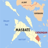
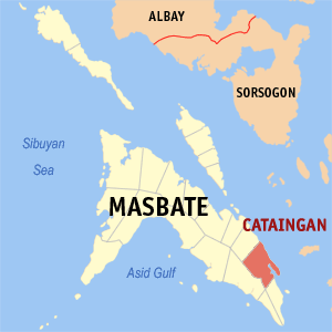
Situated at the foot of the narrow peninsula in the southeastern part of the island province of Masbate and about 77 kilometers southeast of Masbate City is the progressive municipality of Cataingan. It is bounded on the southwest by the municipality of Placer whose town center is linked to Cataingan Poblacion by about 17 kilometers of provincial road, on the north by Palanas, by 19 kilometers, and on the south by Pio V. Corpuz, by 25 kilometers. It is connected to the capital town by concrete asphalt-paved national highway. Its eastern portion faces the Samar Sea, the Poblaacion, itself is situated on a coastal area, facing what is usually referred to as Cataingan Bay.With a land area of 224.21 square kilometers, the municipality of Cataingan has a very progressive economy. This is prefaced by the favourable location at the southeastern seaboard of the island province of Masbate which has become a safe haven for steamers, vessels, motorboats, and sailboats especially during inclement weather.
The Cataingan town center or Poblacion is about 77 kilometers from the provincial capitol town of Masbate. Southward, it is more or less 223 kilometers across the Visayan Sea to Cebu City which serves as one of the progressive outlets of Cataingan’s various agricultural products. Cataingan is also strategically located between the two municipalities of Pio V. Corpuz and Palanas whose trading activities revolve.
Cataingan is where the Orthodox Church
Philippine Orthodox Church
The Philippine Orthodox Church refers to the officially established Eastern Orthodox presence in the Philippines as a whole. Currently, there are two canonical Orthodox jurisdictions:...
was first officially established in the Philippines. The municipality is home to one of the six Orthodox parishes in the Philippines and the country's only Orthodox monastery (see also Exarchate of the Philippines
Exarchate of the Philippines
The Exarchate of the Philippines is a jurisdiction of the Ecumenical Patriarchate of Constantinople governed by the Orthodox Metropolitanate of Hong Kong and Southeast Asia . , there are some 560 members of this jurisdiction in the country, around 40 of those being expatriates...
).
Location and area
Situated at the foot of the narrow peninsula in the southeastern part of the island province of Masbate and about 77 kilometers southeast of Masbate City is the progressive municipality of Cataingan. It is bounded on the southwest by the municipality of Placer whose town center is linked to Cataingan Poblacion by about 17 kilometers of provincial road, on the north by Palanas, by 19 kilometers, and on the south by Pio V. Corpuz, by 25 kilometers. It is connected to the capital town by concrete asphalt-paved national highway. Its eastern portion faces the Samar Sea, the Poblaacion, itself is situated on a coastal area, facing what is usually referred to as Cataingan Bay.Geographically, Cataingan is located at about 123 degrees 55 minutes East Longitude and about 11 degrees 52 minutes North Latitude.
The land area is 224.21 square kilometers, 4.47 km² (2%) is urban and the rest is rural. It is 5.05% the size of Masbate Province.
Topography and land features
The topography of Cataingan is generally rugged, with several fertile plains between the elevation. Although Cataingan is basically a coastal municipality, its bigger portion situated in the hinterlands of Masbate. Including the Poblacion, it is composed of 36 barangays, eight (8) of which are found along the national highway, nine (9) are along the seashore and the rest are in the interior. The general characteristics of the terrain are from gently rolling and sloping to hilly and mountainous.The municipality’s highest elevation is at 300 meters above mean sea level (AMSL) at the northern part which is mountainous; the lowest is located at the coastal portion of the Poblacion and of the other seashore barangay at about 2 meters AMSL.
Although the central part is hilly, it is traversed by several rivers which serve as its natural drainage.
The general direction of the elevation is from the coast and southwestern portion which are level to nearly level converging at the middle where Mt. Bagacay and Mt. Tuybo soar to an elevation of about 300 meters.
Soil
The municipality's land soil is generally classified into five (5) types, namely: Cataingan Soil, 91.93%; Farm-on Soil, 4.25%; Panganiban Soil, 2.55%; Hydrosol, 0.70%; and Batuan Soil, 0.57%. These different kinds of soil were declared capable and reliable for productive farming purposes.Geology
The municipality of Cataingan is reflective of the various geologic formations of the Masbate island basins which consist largely of meta-sedimentary rocks such as argillites, quartzite and marbles. Such geologic formation provides a stable aquifer of groundwater for domestic use.Land use
Cataingan’s land area constitutes 5.05% of the territorial land of Masbate Province.Many of the municipality’s open grasslands and pasture lands may have already been converted to agriculture. Thus, agriculture occupies the biggest percentage of the general land use, of which more than 48% of the total land area are planted to coconuts.
The pasture land, which was a large area and the open grasslands occupy only about 14.55% of the total land use. The site on which the present town is located had been a part of the vast Spanish pasture land on which several corrals were built where a large number of livestock animals, particularly cattle, were raised. Cataingan had derived its name from a derogatory term “kataijan” meaning the place of animal manure because the site was practically covered with animal refuse.
Population data
Eighteen (18) barangays of Cataingan manifested a higher population density. These are barangays Abaca, Aguada, Badiang, Bagumbayan, Concepcion, Gahit, Madamba, Malobago, Mintac, Pawican, San Isidro, San Pedro, Sto. Nino, Tuybo, Poblacion, Domorog, Matayum and Sta. Teresita.Barangays poblacion and Matayum are coastal areas while Domorog, san Pedro, Gahit, Sta. Teresita and Pawican are along the national highway so that being strategically accessible, they tend to attract people who usually converge and engage in different business activities.
Income levels
The considerable dominance of lowest income group is the reality in all the service area barangays. However, households earning between P 3,000 – P 6,000 are relatively more. The significant percentage of the lowest income group is made manifest due to the tendency of fisherman respondents who comprise bulk of the seaside respondents not to put value to their fish catch and sea shells collection for kitchen use or domestic consumption.On the overall, the general picture of the income groupings of the service area household are as follows. Families earning between P 3,000 – P 6,000 comprise nearly one-fourth, 24.56%. An insignificant 0.17% of the respondents earns more than P 30,000 a month.
Facilities
Besides being conveniently accessible, Cataingan has such an available supply of health services that patients from the neighboring town and barangays and from as far as Samar could conveniently avail of.The municipality has a public hospital, the Cataingan District Hospital.
Aside from the Rural Health Unit / Clinic of the Poblacion, there are also a number of health stations/centers in the barangays. There are also some private clinics.
Waste disposal
For solid waste disposal, the municipality relies on several ways of disposing. Majority (63.54%) of the 7,801 households employ burning as a way of disposing wastes. Some use the following manner, namely: dumping (9.31%), composting later to be used as fertilizers (6.23%), feeding to animals (10.61%), burying (9.54%). A very small segment of the households, roughly 0.12%, dispose of their garbage through the garbage truck of the municipality.Agriculture and livestock
With its rolling terrains and wide plains, Cataingan has agriculture as its principal occupation. Coconut is the town’s chief product, with rice, corn, root-crops produced on a minor scale. Coconut farms occupy more than half (59.81%) of the total land area devoted to agriculture or over 48% of the total land area.On the other hand, corn and rice farms occupy roughly 26% and 10% of the total agricultural land, respectively; corn and rice are the staple food of the populace. The rest are planted with bananas, legumes, fruits, vegetables, and other rootcrops. These agricultural crops support the regular income of the local populace.
People living along the coastline engage in highly productive fishing. This is very common since many of the barangays are situated along the seashore.
The land area devoted to pasture is about 3.49% of the total and cattle-raising is very much a part of the people’s activity. Poultry raising and hog production are also very popular in the whole municipality. As a downstream effect, feed-milling is present in the municipality—meeting not only the local demand but also that of the adjacent towns.
Commerce and industry
Historically, Cataingan was once a barangay and part of the municipality of the neighboring town Palanas. It was created into a separate municipality in 1885. The said emancipation ironically made Cataingan much larger in area than its mother town Palanas. bEing situated on a harbor with a serviceable port and protective seawall, it is strategically superior in terms of commercial and agricultural expansion, making it one of the centers of trade and commerce in the various municipalities of Masbate, the provinces of Cebu, Samar, Leyte, Iloilo, Bohol, Negros and the island of Panay.Rice, corn and copra are commodities which are very much in demand in the local trade.
Manufacturing
There are nine (9) of the 36 barangays that compose the municipality have their own respective coastlines. Thus, the people, aside from farming, also engage in small-scale fishing and fish preservation activities like fish drying, smoked-fish making and salting fish. These are packed and shipped to Cebu, Bicol, Mindanao and Manila. Masbate province is generally well-known for its tasty and quality dried fish.However, due to the province’s location at the typhoon-vulnerable eastern coast of the island-province of Masbate, farming is not always reliable, and fishing is not dependable at all times. To forestall this situation, the people of Cataingan make use of all available resources for alternative small-cottage industries that are less vulnerable to the long-term effects of weather-induced natural calamities.
Since backyard cattle production, poultry and hog-raising are also popular in Cataingan, a downstream effect, like feed-milling, is present in the municipality—meeting not only the local demand but also that of the adjacent towns.
The inland.upland dwellers in Cataingan’s barangays are also engaged in coconut wine (tuba) production. Tuba is fermented and made into vinegar—one of the best products of the municipality that are marketed in mainland Masbate and even in the Bicol region and Metro Manila.
The presence of a sufficient amount of guano deposits in the barangays of San Rafael, Libtong, Pawican and San Pedro could be tapped to provide raw materials in the production of organic fertilizers, which the local farmers could utilize on their farms or trade with other communities.
Tourism
Cataingan is endowed with some natural attractions, which includes white beaches, caves, natural springs, ski-diving and swimming areas.The municipality has many white beaches, for instance, the Gutusan Beach. It has sparkling white sand. At times, however, when sea current is very strong, the sand turns from white to blackish. During fair weather, the water is so clear that assorted schools of fish, various coral formations and large boulders can be seen beneath the placid waters. The Khokak Beach is one of the sought-after beaches in town. Its proprietor is the Kho family. Near the beach is the Pampang where big stones sleep.
The so-called "KRUS" in San Rafael is visited by many specially teenagers who are known to be adventure-seekers. The whole town can be seen from this place.
Education
Cataingan has a number of public elementary schools, high schools, and two colleges, the Cataingan Municipal College and the Ovilla Technical College.Cataingan Municipal College offers two-year courses such as Computer Secretarial and Junior Secretarial, and four-year Bachelor degrees. The head is Wilton T. Kho, the municipal mayor. It has a school magazine, The Eagle, first published in April,2008.
Cataingan National High School is based in Poblacion, Cataingan. Elementary schools include Potenciano A. Abejero Elementary School (PAAES) and Emilio S. Boro Sr. Elementary School, both situated in the town proper. All barangays have their own elementary schools. While barangays Badiang, Cadulawan, Cagbatang, Pawican, & Liong also have their own secondary schools.
Transportation
Cataingan’s strength lies in its being a coastal municipality, with its agricultural and sea produce either traded to Cebu or Masbate City. But such potential cannot be optimized without a stable transportation and communication facilities. Its primary mode of transportation for trading purposes is by land transport—ferrying rice, corn, copra, fish, cattle, root crops and other agricultural products.The existing act of conveyance facilities plying in and out of the municipality are: buses, L-300s, vans, public utility jeeps, tricycles and single motorcycles motorized pump boats and paddled canoes. The municipality has a regular schedule of bigger island vessels for cargo and passenger transport from Cebu. There are other bigger pump boats which occasionally ferry passengers from the municipality to Leyte and Samar and vice versa.
Telecommunication
A post office serves the total population of the municipality. Mailing needs, telegraphic transfers and telegraphs are handled by the same service facilities. There are no private postal or delivery services operating in the vicinity.There are also some privately-owned public calling stations which caters local and overseas calls.
Messages may also be sent by the wireless system through the provincial law enforcement communication system (PLECS) where they may transmitted by VHF radio. There is no radio station in the municipality but broadcasts from Cebu, the Bicol Region, the Panay Islands, Metro Manila and Masbate are audible in the municipality.
With the update, Cataingan is now powered with wireless communication system through Smart Telecommunication and Globe. It has even an internet provider to allow people of this municipality to connect globally in just a simple click.
There is a big room for improvement in the field of telecommunications. It is, however, recognized that state-of-the-art communication facilities follow where booming trade and upbeat business are present.
Power/electricity
Cataingan is energized by the Masbate Electric Cooperative (MASELCO), through the latter’s power generation plant located at the municipality of Mobo. There is, however, a bright prospect that in the future, a least costly coal-fired power plant is established. Coal is an abundant resource in the island that lies dormant underneath its soil.Plans and development
- The existing rock causeway that serves the landing needs of the inter-island vessels and of the local fisherman shall be extended and developed in to a functional port whereof passenger/cargo ships can easily dock and make inter-island travel conveniently safe and available in Cataingan.
- An adequate potable waterworks system shall be established for the whole town of Cataingan. The existing system will be rehabilitated and expanded to be able to respond to the water needs/demands of the populace. This is topmost in the LGU’s hierarchy of priority. At stake are the health benefits, as well as the social and economic well-being of the people.
- Cataingan is also one of the bundant fishing grounds of Masbate. The absence of good and reliable fishport, however, results into majority of the fish harvest bypassing Cataingan itself and the opportunity of greater economic activity is lost in the process. A respectable fish port is also the precursor of other downstream industries like fish canneries and other fish processing business. Its establishment and/or improvement would considerably enhance the economic progress of the municipality.
- Parallel with other projects, budgetary allocations and requests for grant assistance from various provincial and national government agencies shall be made in order to pursue this service aspect. None better contributes to a vibrant economy than the opening/rehabilitation/concreting of farm-to-market roads. Consequently, farmers’ various agricultural products will be conveniently transported to the town center, thereby increasing the family income.
- The LGU is determined at allocating part of its scarce resources for the computerization of all municipal government transactions. This thrust will free more personnel to community/field work and lessen the clerical work-load in the office. This is in line with the national government thrust in information technology as a key contributor to national capability building.
Barangays
Cataingan is politically subdivided into 36 barangayBarangay
A barangay is the smallest administrative division in the Philippines and is the native Filipino term for a village, district or ward...
s.
|
|
MAYOR:Wilton T. Kho SK FEDERATION:Francisco D. Booc III |
External links
- http://abante-cataingan.tripod.com
- Philippine Standard Geographic Code
- 2000 Philippine Census Information
- http://elgu2.ncc.gov.ph/cataingan/index.php?cat1=1