
Casey, Australian Capital Territory
Encyclopedia
Casey is a suburb in Canberra
, Australia
, approximately 4 km from the Gungahlin Town Centre
and about 13 km from the centre of Canberra
. The suburb is named after Richard Casey, Baron Casey
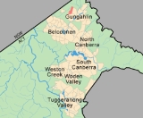
an Australian politician, diplomat and later the 16th Governor-General of Australia. It is bound by Horse Park Drive and Clarrie Hermes Drive. Casey is located in north-west Gungahlin
, adjacent to the suburbs of Nicholls
and Ngunnawal
, and the future suburbs of Kinlyside
, Taylor
and Moncrieff
.
The suburb draws its place names from notable Australian diplomats, public servants and administrators. Former Lieutenant-Governor of South Australia Walter Crocker
and Sir John Overall
, the former head of the National Capital Development Commission
are honoured by place names in Casey.
 Until 1990, Casey was part of the former 'Gold Creek' a 3940 acres (15.9 km²) rural property with the Gold Creek Homestead at its centre. The relative flat and even topography of portions of the suburb of Casey was ideal for various pursuits including horse racing, and was the site of a practice track for racing horses. A stand of trees parallel to Horse Park Drive which predates the establishment of the village (now the suburb) of Hall
marks the original alignment of the Queanbeyan-Yass Road.
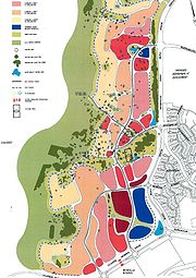
Casey will eventually occupy an area approximately 192 ha in size and accommodate 1,940 dwellings, including about 275 medium density units in the commercial centres. A Group (Shopping) Centre will be constructed in the south-east corner of the suburb near the corner of Horse Park and Clarrie Hermes Drives. A second and minor commercial centre planned for Casey will be built at the northern end of the suburb nearest the future suburb of Taylor. The Group Centre is expected to incorporate a retail core clustered around a 'central green-node' similar to Green Square in Kingston
. To improve accessibility of the Group Centre, it is expected that Clarrie Hermes Drive will be extended through to the Barton Highway at its westerly end in parallel with or at the conclusion of Casey's development
Casey is underlaid by rocks from the Silurian
period. Along the hill tops the rock is from the Hawkins Volcanics, with mostly dacite
in the south, and andesite
in the north. The north east of the suburb has dacite from the Canberra Formation. The south east has a green grey porphyry
with a dacite like composition, and visible white feldspar
crystals.
Canberra
Canberra is the capital city of Australia. With a population of over 345,000, it is Australia's largest inland city and the eighth-largest city overall. The city is located at the northern end of the Australian Capital Territory , south-west of Sydney, and north-east of Melbourne...
, Australia
Australia
Australia , officially the Commonwealth of Australia, is a country in the Southern Hemisphere comprising the mainland of the Australian continent, the island of Tasmania, and numerous smaller islands in the Indian and Pacific Oceans. It is the world's sixth-largest country by total area...
, approximately 4 km from the Gungahlin Town Centre
Gungahlin
Gungahlin is a name of a district and the northernmost town centre of Canberra, Australia. Gungahlin is situated 10 km north of Canberra's city centre and is one of five satellites of Canberra including Woden, Tuggeranong, Weston Creek and Belconnen. Currently Gungahlin comprises 11 suburbs,...
and about 13 km from the centre of Canberra
Canberra
Canberra is the capital city of Australia. With a population of over 345,000, it is Australia's largest inland city and the eighth-largest city overall. The city is located at the northern end of the Australian Capital Territory , south-west of Sydney, and north-east of Melbourne...
. The suburb is named after Richard Casey, Baron Casey
Richard Casey, Baron Casey
Richard Gardiner Casey, Baron Casey KG GCMG CH DSO MC KStJ PC was an Australian politician, diplomat and the 16th Governor-General of Australia.-Early life:...
an Australian politician, diplomat and later the 16th Governor-General of Australia. It is bound by Horse Park Drive and Clarrie Hermes Drive. Casey is located in north-west Gungahlin
Gungahlin
Gungahlin is a name of a district and the northernmost town centre of Canberra, Australia. Gungahlin is situated 10 km north of Canberra's city centre and is one of five satellites of Canberra including Woden, Tuggeranong, Weston Creek and Belconnen. Currently Gungahlin comprises 11 suburbs,...
, adjacent to the suburbs of Nicholls
Nicholls, Australian Capital Territory
Nicholls is a suburb in the Canberra, Australia district of Gungahlin is named after Sir Douglas Nicholls , a former Governor of South Australia. It was gazetted on 18 October 1991. Streets are named after sportsmen and sportswomen....
and Ngunnawal
Ngunnawal, Australian Capital Territory
Ngunnawal is a suburb in the district of Gungahlin in Canberra, Australia. The suburb is named in tribute to the Ngunnawal people, the original inhabitants of the area. The suburb was gazetted on 18 October 1991. Ngunnawal is adjacent to the suburbs of Nicholls, Casey and Amaroo and Taylor...
, and the future suburbs of Kinlyside
Kinlyside, Australian Capital Territory
Kinlyside is a designated suburb in Gungahlin, Canberra. The land designated for the suburb has not yet been released for development by the Australian Capital Territory’s Land and Development Agency ....
, Taylor
Taylor, Australian Capital Territory
Taylor is a designated suburb in Gungahlin, Canberra though the first land release is yet to be announced. The suburb is named after magazine publisher Florence Taylor OBE, who was editor of and writer for several Australian building industry journals including the influential 'Building' magazine...
and Moncrieff
Moncrieff, Australian Capital Territory
Moncrieff is a designated suburb of Gungahlin, Canberra, the National Capital of Australia. The name was gazetted in April 1991 though no official announcement has to be made about the first land release. It is named after Gladys Moncrieff, an Australian singer of the 1920-30s musical era who was...
.
The suburb draws its place names from notable Australian diplomats, public servants and administrators. Former Lieutenant-Governor of South Australia Walter Crocker
Walter Crocker
Sir Walter Russell Crocker KBE was an Australian diplomat, writer and war veteran.He was born in Broken Hill, New South Wales, the eldest son of Robert Crocker and Alma Bray. He served in World War II with the British Army, becoming a Lieutenant Colonel...
and Sir John Overall
John Overall (architect)
Sir John Wallace Overall CBE, MC & Bar was an Australian World War II veteran and architect.Overall served as an officer in the Australian Imperial Force during the Second World War, where he was awarded the Military Cross for "great courage, devotion and initiative" in 1941 for his service during...
, the former head of the National Capital Development Commission
National Capital Development Commission
The National Capital Development Commission was an Australian Commonwealth Government body created to complete the establishment of Canberra as the seat of government. It was created in 1957 through the National Capital Development Commission Act 1957.Under the control of the NCDC Canberra grew...
are honoured by place names in Casey.
History
Hall, Australian Capital Territory
Hall is a small town in the north of the Australian Capital Territory , Australia. It was founded in 1882, named after the first landholder in the area, Henry Hall. In 1911 Hall was included within the boundary of the land allocated for the Australian Capital Territory, close to the north western...
marks the original alignment of the Queanbeyan-Yass Road.
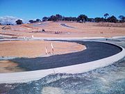
Development
Construction work on road and other infrastructure for Casey commenced in September 2008. In December 2009, Overall Avenue, the connector road for Casey Stage 1, opened to traffic between Clarrie Hermes Drive and Horsepark Drive. During this period stormwater infrastructure including a sediment pond was also completed. (pictured below right)Casey will eventually occupy an area approximately 192 ha in size and accommodate 1,940 dwellings, including about 275 medium density units in the commercial centres. A Group (Shopping) Centre will be constructed in the south-east corner of the suburb near the corner of Horse Park and Clarrie Hermes Drives. A second and minor commercial centre planned for Casey will be built at the northern end of the suburb nearest the future suburb of Taylor. The Group Centre is expected to incorporate a retail core clustered around a 'central green-node' similar to Green Square in Kingston
Kingston, Australian Capital Territory
Kingston is the oldest and most densely populated suburb of Canberra, Australian Capital Territory, Australia. The suburb is named after Charles Cameron Kingston, the former Premier of South Australia and minister in the first Australian Commonwealth Government. It is adjacent to the suburbs of...
. To improve accessibility of the Group Centre, it is expected that Clarrie Hermes Drive will be extended through to the Barton Highway at its westerly end in parallel with or at the conclusion of Casey's development
Geology
The landscape slopes to the south east, with a line of hills forming a ridge on the north west side making a backdrop. The low point is 622 meters at the roundabout joining Gungahlin Drive, Horse Park Drive and Clarrie Hermes drive. The highest point is 726 meters in the north west corner.Casey is underlaid by rocks from the Silurian
Silurian
The Silurian is a geologic period and system that extends from the end of the Ordovician Period, about 443.7 ± 1.5 Mya , to the beginning of the Devonian Period, about 416.0 ± 2.8 Mya . As with other geologic periods, the rock beds that define the period's start and end are well identified, but the...
period. Along the hill tops the rock is from the Hawkins Volcanics, with mostly dacite
Dacite
Dacite is an igneous, volcanic rock. It has an aphanitic to porphyritic texture and is intermediate in composition between andesite and rhyolite. The relative proportions of feldspars and quartz in dacite, and in many other volcanic rocks, are illustrated in the QAPF diagram...
in the south, and andesite
Andesite
Andesite is an extrusive igneous, volcanic rock, of intermediate composition, with aphanitic to porphyritic texture. In a general sense, it is the intermediate type between basalt and dacite. The mineral assemblage is typically dominated by plagioclase plus pyroxene and/or hornblende. Magnetite,...
in the north. The north east of the suburb has dacite from the Canberra Formation. The south east has a green grey porphyry
Porphyry (geology)
Porphyry is a variety of igneous rock consisting of large-grained crystals, such as feldspar or quartz, dispersed in a fine-grained feldspathic matrix or groundmass. The larger crystals are called phenocrysts...
with a dacite like composition, and visible white feldspar
Feldspar
Feldspars are a group of rock-forming tectosilicate minerals which make up as much as 60% of the Earth's crust....
crystals.