

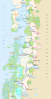
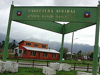
Carretera Austral
Encyclopedia
Chile
Chile ,officially the Republic of Chile , is a country in South America occupying a long, narrow coastal strip between the Andes mountains to the east and the Pacific Ocean to the west. It borders Peru to the north, Bolivia to the northeast, Argentina to the east, and the Drake Passage in the far...
's Route 7. The highway runs about 1240 kilometres (770.5 mi) from Puerto Montt
Puerto Montt
Puerto Montt is a port city and commune in southern Chile, located at the northern end of the Reloncaví Sound in the Llanquihue Province, Los Lagos Region. The commune spans an area of and had a population of 175,938 in 2002. It is located 1,055 km to the south of the capital, Santiago...
to Villa O'Higgins
Villa O'Higgins
Villa O'Higgins is a village in southern Chile, located in the Capitán Prat Province, in the south of Aisén Region. It is the capital of the O'Higgins commune and marks the end of the Carretera Austral. The village is named after Chilean independence hero Bernardo O'Higgins.-Facilities:The village...
through rural Patagonia
Patagonia
Patagonia is a region located in Argentina and Chile, integrating the southernmost section of the Andes mountains to the southwest towards the Pacific ocean and from the east of the cordillera to the valleys it follows south through Colorado River towards Carmen de Patagones in the Atlantic Ocean...
.
Carretera Austral provides road access to Chile's Aisén Region and southern part of Los Lagos Region
Los Lagos Region
Los Lagos Region is one of Chile's 15 regions, which are first order administrative divisions, and comprises four provinces: Chiloé, Llanquihue, Osorno and Palena. The region contains the country's second largest island, Chiloé, and the second largest lake, Llanquihue.Its capital is Puerto Montt;...
. These areas are sparsely populated and despite its length, Carretera Austral provides access to only about 100,000 people. South of the highway's start in Puerto Montt, Coyhaique
Coyhaique
Coihaique , also spelled Coyhaique in Patagonia, is the capital city of both the Coihaique Province and the Aysén Region of Chile. Founded by settlers in 1929, it is a young city. Until the twentieth century, Chile showed little interest in exploiting the remote Aisén region...
(population 44,850) is the largest city along it.
History
Augusto Pinochet
Augusto José Ramón Pinochet Ugarte, more commonly known as Augusto Pinochet , was a Chilean army general and dictator who assumed power in a coup d'état on 11 September 1973...
in order to connect a number of remote communities. Before that, in the 1950s and 1970s, there had been unsuccessful attempts to build access roads in the region. It is among the most ambitious infrastructure projects developed in Chile during the 20th century.
Carretera Austral has a strategic meaning due to the difficult access by land to a significant portion of Chile's southern territory. This area is characterized by thick forests, fjords, glaciers, canals and steep mountains. Access by sea and air is also a complex task due to extreme winter weather conditions. For decades, most of the land transportation had to cross the border to Argentina in order to reach again Chile's Patagonia
Patagonia
Patagonia is a region located in Argentina and Chile, integrating the southernmost section of the Andes mountains to the southwest towards the Pacific ocean and from the east of the cordillera to the valleys it follows south through Colorado River towards Carmen de Patagones in the Atlantic Ocean...
. These difficulties were deepened during the 1970s due to the Beagle Conflict
Beagle conflict
The Beagle Conflict was a border dispute between Chile and Argentina over the possession of Picton, Lennox and Nueva islands and the scope of the maritime jurisdiction associated with those islands that brought the countries to the brink of war in 1978....
crisis. In order to strengthen the Chilean presence in these isolated territories and ensure the land connection to the rest of the country, the government planned the construction of this road, which was executed by the Chilean Army
Chilean Army
The Chilean Army is the land arm of the Military of Chile. This 45,000-person army is organized into seven divisions, a special operations brigade and an air brigade....
's Engineering Command. More than 10,000 soldiers worked in its construction. Many of them lost their lives during this effort.
The highway opened to traffic in 1988, and by 1996 was completed to Puerto Yungay. The last 100 kilometres (62.1 mi) to Villa O'Higgins were opened in 2000. In 2003, a branch road to Caleta Tortel
Caleta Tortel
Caleta Tortel is a coastal village in Chile. It is the administrave center of the commune of Tortel and is located between the mouth of the Baker River and a small embayment of the Baker Channel. The surrounding geography is rugged, formed by a number of islands, fjords, channels and estuaries...
was finished.
Places along the highway
- Puerto MonttPuerto MonttPuerto Montt is a port city and commune in southern Chile, located at the northern end of the Reloncaví Sound in the Llanquihue Province, Los Lagos Region. The commune spans an area of and had a population of 175,938 in 2002. It is located 1,055 km to the south of the capital, Santiago...
- Reloncaví SoundReloncaví SoundReloncaví Sound or Seno de Reloncaví is a body of water located immediately south of Puerto Montt, Chile. It is the place where the Intermediate Depression falls into the Pacific Ocean. There are several islands in the sound including Tenglo Island, Maillén Island and Huar Island...
- Hornopirén National ParkHornopirén National ParkHornopirén National Park is located in the Andes, in the Palena Province of Chile's Los Lagos Region. The park contains of rugged mountains and unspoiled Valdivian temperate rain forests. This national park borders the northern portion of Pumalín Park. The Carretera Austral passes close to the park...
- Yelcho LakeYelcho LakeYelcho Lake is a fjord-shaped lake located in the southern Los Lagos Region, in the Palena Province, Chile. Its outlet is a river of the same name, which flows north-west and empties into Gulf of Corcovado, near Chaitén. The lake is fed by the Futaleufú River. The Carretera Austral runs along its...
- ChaiténChaiténChaitén is a Chilean town, commune and former capital of the Palena Province in Los Lagos Region. The town is located north of the mouth of Yelcho River, on the east coast of the Gulf of Corcovado...
- Queulat National ParkQueulat National ParkQueulat National Park is a national park of Chile located in the Aisén Region. The park is bordered by the Cisnes River on the south side and is neighbor to Lago Rosselot National Reserve...
- CoyhaiqueCoyhaiqueCoihaique , also spelled Coyhaique in Patagonia, is the capital city of both the Coihaique Province and the Aysén Region of Chile. Founded by settlers in 1929, it is a young city. Until the twentieth century, Chile showed little interest in exploiting the remote Aisén region...
- BalmacedaBalmaceda, ChileBalmaceda is a Chilean village located south east of Coyhaique in Aisén Region. Balmaceda has around 500 inhabitants, and has Aysen Regions largest airport and meteorological station; Balmaceda Airport. The first settlers arrived into the zone in early-20th century after being expelled from...
- Río IbáñezRío Ibáñez, ChileRío Ibáñez is a commune in General Carrera Province, Aisén Region, Chile. It is named after Ibáñez River, a major tributary of General Carrera Lake....
- Cerro CastilloCerro CastilloCerro Castillo is a jagged rocky peak located in the Aisén Region of Chile, within the Cerro Castillo National Reserve. Castillo means castle in Spanish, and the steep basalt walls of the mountain indeed make it look like one. On its sides are a few small glaciers and lakes fed by...
- General Carrera LakeBuenos Aires/General Carrera LakeThe Lake General Carrera or Lake Buenos Aires is a lake located in Patagonia and shared by Argentina and Chile...
- CochraneCochrane, ChileCochrane is a Chilean town and commune in Capitán Prat Province of the Aisén Region. According to the 2002 census it has a population of 2,867. The urban population in 2002 was 2,217 and the rural population was 650....
- Baker RiverBaker River (Chile)The Baker River is a river located in the Aisén Region of the Chilean Patagonia. It is Chile's largest river in terms of volume of water. The river flows out of Bertrand Lake, which is fed by General Carrera Lake. It runs along the east side of the Northern Patagonian Ice Field and empties into the...
- Caleta TortelCaleta TortelCaleta Tortel is a coastal village in Chile. It is the administrave center of the commune of Tortel and is located between the mouth of the Baker River and a small embayment of the Baker Channel. The surrounding geography is rugged, formed by a number of islands, fjords, channels and estuaries...
- Villa O'HigginsVilla O'HigginsVilla O'Higgins is a village in southern Chile, located in the Capitán Prat Province, in the south of Aisén Region. It is the capital of the O'Higgins commune and marks the end of the Carretera Austral. The village is named after Chilean independence hero Bernardo O'Higgins.-Facilities:The village...
Ferry crossings
Traveling the entire route requires the use of three ferriesFerry
A ferry is a form of transportation, usually a boat, but sometimes a ship, used to carry primarily passengers, and sometimes vehicles and cargo as well, across a body of water. Most ferries operate on regular, frequent, return services...
:
- a 30 minute crossing about 45 kilometres (28 mi) south of the start of the highway in Puerto Montt
- a 5 hour crossing from Hornopiren (110 kilometers (68 miles) south of Puerto Montt) to Caleta Gonzalo
- a 50 minute crossing from Puerto Yungay to Rio Bravo, connecting to the final 100 kilometres (62.1 mi) of the highway.
The ferry from Hornopiren to Caleta Gonzalo only runs during January and February. Thus, for ten months of the year it is not possible to travel straight down the Carretera Austral. The portion of the road south of Hornopiren is connected to Argentina
Argentina
Argentina , officially the Argentine Republic , is the second largest country in South America by land area, after Brazil. It is constituted as a federation of 23 provinces and an autonomous city, Buenos Aires...
year-round though, using several border crossings along the way.
Current activity
The highway began as almost entirely unpaved, but more sections are becoming paved each year. As of 2008, most of the road is still unpaved.On October 5, 2006, construction of a road between Hornopirén and Chaitén, crossing Pumalín
Pumalín Park
Pumalín Park is a private nature reserve in the Palena Province of Chile, created by the United States environmental foundation The Conservation Land Trust, which is endowed and led by the American business magnate Douglas Tompkins...
, was announced. The project is estimated to have a cost of some 100 million US
Dollars.
There is also a plan to extend the road to Magallanes Region, which still lacks domestic road connection to the rest of Chile. This means constructing a 935 kilometres (581 mi) branch Rio Bravo-Ventisquero Montt
Jorge Montt Glacier
Jorge Montt Glacier is a tidewater glacier located in the Aisén Region of Chile, south of the town of Caleta Tortel. It lies at the north end of the Southern Patagonian Ice Field, within Bernardo O'Higgins National Park. The mouth of Pascua River is located in the vicinity of the glacier calving...
-Puerto Natales
Puerto Natales
Puerto Natales is a city in Chilean Patagonia. Puerto Natales is the capital of both the commune of Natales and the province of Última Esperanza, , one of the four provinces that make up the Magallanes and Antartica Chilena Region in the southernmost part of Chile...
, with 9 ferry crossings planned. By January 2007, the construction on the Rio Bravo-Ventisquero Montt section had begun, with the branch off point from the main Rio Bravo-Villa O'Higgins road being at 48.00°S 73.13°W.