

Canton-Massillon metropolitan area
Encyclopedia
United States Census Bureau
The United States Census Bureau is the government agency that is responsible for the United States Census. It also gathers other national demographic and economic data...
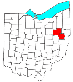
, is an area consisting of two counties in northeastern Ohio
Ohio
Ohio is a Midwestern state in the United States. The 34th largest state by area in the U.S.,it is the 7th‑most populous with over 11.5 million residents, containing several major American cities and seven metropolitan areas with populations of 500,000 or more.The state's capital is Columbus...
, anchored by the cities of Canton
Canton, Ohio
Canton is the county seat of Stark County in northeastern Ohio, approximately south of Akron and south of Cleveland.The City of Caton is the largest incorporated area within the Canton-Massillon Metropolitan Statistical Area...
and Massillon
Massillon, Ohio
Massillon is a city located in Stark County in the U.S. state of Ohio, approximately 8 miles to the west of Canton, Ohio, 20 miles south of Akron, Ohio, and 50 miles south of Cleveland, Ohio. The population was 32,149 at the 2010 census....
. As of the 2010 census
United States Census, 2010
The Twenty-third United States Census, known as Census 2010 or the 2010 Census, is the current national census of the United States. National Census Day was April 1, 2010 and is the reference date used in enumerating individuals...
, the MSA had a population of 404,422.
Incorporated Cities with more than 30,000 inhabitants
- CantonCanton, OhioCanton is the county seat of Stark County in northeastern Ohio, approximately south of Akron and south of Cleveland.The City of Caton is the largest incorporated area within the Canton-Massillon Metropolitan Statistical Area...
(Principal city) - MassillonMassillon, OhioMassillon is a city located in Stark County in the U.S. state of Ohio, approximately 8 miles to the west of Canton, Ohio, 20 miles south of Akron, Ohio, and 50 miles south of Cleveland, Ohio. The population was 32,149 at the 2010 census....
(Principal city)
Townships with more than 30,000 inhabitants
- Jackson TownshipJackson Township, Stark County, OhioJackson Township is one of the seventeen townships of Stark County, Ohio, United States. The 2000 census found 37,744 people in the township, 37,484 of whom lived in the unincorporated portions of the township.-Geography:...
- Perry TownshipPerry Township, Stark County, OhioPerry Township is one of the seventeen townships of Stark County, Ohio, United States. It is an urban township; the 2000 census found 29,167 people in the township.-Geography:Located in the western part of the county, it borders the following townships:...
- Plain TownshipPlain Township, Stark County, OhioPlain Township is one of the seventeen townships of Stark County, Ohio, United States. The 2000 census found 51,997 people in the township, 35,543 of whom lived in the unincorporated portions of the township...
Incorporated Cities with 10,000 to 30,000 inhabitants
- AllianceAlliance, OhioAlliance is a city in Stark and Mahoning counties in the U.S. state of Ohio. The population was 22,322 at the 2010 census. Alliance's nickname is "The Carnation City", and the city is home to the University of Mount Union....
(partial) - North CantonNorth Canton, OhioAs of the census of 2000, there were 16,369 people, 7,114 households, and 4,382 families residing in the city. The population density was 2,697.1 people per square mile . There were 7,506 housing units at an average density of 1,236.8 per square mile...
Townships with 10,000 to 30,000 inhabitants
- Canton TownshipCanton Township, Stark County, OhioCanton Township is one of the seventeen townships of Stark County, Ohio, United States. The 2000 census found 13,882 people in the township, 13,402 of whom lived in the unincorporated portions of the township.-Geography:...
- Lake TownshipLake Township, Stark County, OhioLake Township is one of the seventeen townships of Stark County, Ohio, United States. It is an urban township; the 2000 census found 25,892 people in the township, 23,718 of whom lived in the unincorporated portions of the township.-Geography:...
- Lawrence TownshipLawrence Township, Stark County, OhioLawrence Township is one of the seventeen townships of Stark County, Ohio, United States. The 2000 census found 13,382 people in the township, 8,321 of whom lived in the unincorporated portions of the township.-Geography:...
- Nimishillen TownshipNimishillen Township, Stark County, OhioNimishillen Township is one of the seventeen townships of Stark County, Ohio, United States. The 2000 census found 9,098 people in the township.-Geography:Located in the eastern part of the county, it borders the following townships:...
Places with 1,000 to 10,000 inhabitants
- Beach CityBeach City, OhioBeach City is a village in Stark County, Ohio, United States. The population was 1,137 at the 2000 census. It is part of the Canton–Massillon Metropolitan Statistical Area.-Geography:Beach City is located at , along Sugar Creek....
- BrewsterBrewster, OhioBrewster is a village in Stark County, Ohio, United States. The population was 2,324 at the 2000 census. It is part of the Canton–Massillon Metropolitan Statistical Area.-Geography:Brewster is located at , along Sugar Creek....
- Canal FultonCanal Fulton, OhioCanal Fulton is a city in Stark County in the U.S. state of Ohio. The population was 5,479 at the 2010 census. It is part of the Canton–Massillon Metropolitan Statistical Area.-Geography:...
- CarrolltonCarrollton, OhioCarrollton is a village in Carroll County, Ohio, United States. The population was 3,190 at the 2000 census. It is the county seat of Carroll County.Carrollton is part of the Canton–Massillon Metropolitan Statistical Area.- History :...
- East CantonEast Canton, OhioEast Canton is a village in Stark County in the U.S. state of Ohio. The population was 1,629 at the 2000 census. It is part of the Canton–Massillon Metropolitan Statistical Area....
- GreentownGreentown, OhioGreentown is a census-designated place in Stark County, Ohio, United States. The population was 3,154 at the 2000 census. It is part of the Canton–Massillon Metropolitan Statistical Area.-Geography:Greentown is located at ....
(census-designated placeCensus-designated placeA census-designated place is a concentration of population identified by the United States Census Bureau for statistical purposes. CDPs are delineated for each decennial census as the statistical counterparts of incorporated places such as cities, towns and villages...
) - HartvilleHartville, OhioHartville is a village in Stark County, Ohio, United States. The population was 2,174 at the 2000 census. It is part of the Canton–Massillon Metropolitan Statistical Area....
- LouisvilleLouisville, OhioLouisville is a city in Stark County in the U.S. state of Ohio. The population was 9,186 at the 2010 census. It is part of the Canton–Massillon Metropolitan Statistical Area.Louisville is also known as the "Constitution Town". -Geography:...
- MalvernMalvern, OhioMalvern is a village in Carroll County, Ohio, United States. The population was 1,218 at the 2000 census. It is part of the Canton–Massillon Metropolitan Statistical Area.-Geography:Malvern is located at , along Sandy Creek....
- MinervaMinerva, OhioMinerva is a village in Carroll, Columbiana, and Stark counties in the U.S. state of Ohio. The population was 3,934 at the 2000 census.The Carroll and Stark County portions of Minerva are part of the Canton–Massillon Metropolitan Statistical Area, while the Columbiana County portion is part...
(partial) - NavarreNavarre, OhioNavarre is a village in Stark County, Ohio, United States. The population was 1,440 at the 2000 census...
- Perry HeightsPerry Heights, OhioPerry Heights is a census-designated place in Stark County, Ohio, United States. The population was 8,900 at the 2000 census. It is part of the Canton–Massillon Metropolitan Statistical Area...
(census-designated place) - UniontownUniontown, OhioUniontown is a census-designated place in Stark County, Ohio, United States. The population was 2,802 at the 2000 census. Uniontown was named #69 on CNN Money's list.Uniontown is part of the Canton–Massillon Metropolitan Statistical Area....
(census-designated place) - WaynesburgWaynesburg, OhioWaynesburg is a village in Stark County, Ohio, United States. The population was 923 at the 2010 census, a decrease from 1,003 in 2000. It is part of the Canton–Massillon Metropolitan Statistical Area.-Geography:...
Places with less than 1,000 inhabitants
- DellroyDellroy, OhioDellroy is a village in Carroll County, Ohio, United States. The population was 294 at the 2000 census. It is part of the Canton–Massillon Metropolitan Statistical Area.- History :...
- East SpartaEast Sparta, OhioEast Sparta is a village in Stark County, Ohio, United States. The population was 806 at the 2000 census. It is part of the Canton–Massillon Metropolitan Statistical Area.-Geography:...
- Hills and DalesHills and Dales, OhioHills and Dales is a village in Stark County, Ohio, United States. The population was 260 at the 2000 census. It is an affluent, upper-middle class suburban enclave near Canton, with several roads into the village closed by locked gates....
- LeesvilleLeesville, OhioLeesville is a village in Carroll County, Ohio, United States. The population was 184 at the 2000 census. It is part of the Canton–Massillon Metropolitan Statistical Area.-History:...
- LimavilleLimaville, OhioLimaville is a village in Stark County, Ohio, United States. The population was 193 at the 2000 census. It is part of the Canton–Massillon Metropolitan Statistical Area.-Geography:Limaville is located at ....
- MagnoliaMagnolia, OhioMagnolia is a village in Carroll and Stark Counties in the U.S. state of Ohio. The population was 931 at the 2000 census. It is part of the Canton–Massillon Metropolitan Statistical Area.-History:...
- Meyers LakeMeyers Lake, OhioMeyers Lake is a village in Stark County in the U.S. state of Ohio. The population was 565 at the 2000 census. It is part of the Canton–Massillon Metropolitan Statistical Area.-Geography:Meyers Lake is located at ....
- SherrodsvilleSherrodsville, OhioSherrodsville is a village in Carroll County, Ohio, United States. The population was 316 at the 2000 census. It is part of the Canton–Massillon Metropolitan Statistical Area.-Geography:...
- WilmotWilmot, OhioWilmot is a village in Stark County, Ohio, United States. The population was 335 at the 2000 census. It is part of the Canton–Massillon Metropolitan Statistical Area.-Geography:Wilmot is located at ....
Unincorporated places
- AugustaAugusta, OhioAugusta is an unincorporated community in eastern Augusta Township, Carroll County, Ohio, United States. Although it is unincorporated, it has a post office, with the ZIP code of 44607. It lies along State Route 9...
- AvondaleAvondale, Stark County, OhioAvondale is an unincorporated community in southwestern Plain Township, Stark County, Ohio, United States. Located just northwest of Canton and north of Meyers Lake, its altitude is 1,135 feet ....
- CairoCairo, Stark County, OhioCairo is an unincorporated community in far northern Plain Township, Stark County, Ohio, United States. Its altitude is 1,145 feet . The community is part of the Canton–Massillon Metropolitan Statistical Area.-References:...
- Harlem SpringsHarlem Springs, OhioHarlem Springs is an unincorporated community in central Lee Township, Carroll County, Ohio, United States. Although it is unincorporated, it has a post office, with the ZIP code of 44631. It lies along State Route 43...
- MarchandMarchand, OhioMarchand is an unincorporated community in northeastern Jackson Township, Stark County, Ohio, United States, a short distance west of North Canton. Marchand is a historical locality that contains very few businesses, surrounded by a railroad line...
- MaximoMaximo, OhioMaximo is an unincorporated community in eastern Washington Township, Stark County, Ohio, United States. Although it is unincorporated, it has a post office, with the ZIP code of 44650...
- MechanicstownMechanicstown, OhioMechanicstown is an unincorporated community in northwestern Fox Township, Carroll County, Ohio, United States. Although it is unincorporated, it has a post office, with the ZIP code of 44651. It lies at the intersection of State Routes 39 and 524...
- MiddlebranchMiddlebranch, OhioMiddlebranch is an unincorporated community in northeastern Plain Township, Stark County, Ohio, United States. Although it is unincorporated, it has a post office, with the ZIP code of 44652. The community is part of the Canton–Massillon Metropolitan Statistical Area.-References:...
- New FranklinNew Franklin, Stark County, Ohio.New Franklin is an unincorporated community in northeastern Paris Township, Stark County, Ohio, United States, lying at the intersection of State Routes 172 and 183. The community is part of the Canton–Massillon Metropolitan Statistical Area....
- North IndustryNorth Industry, OhioNorth Industry is an unincorporated community in southern Canton Township, Stark County, Ohio, United States, along the Nimishillen Creek. Its altitude is 1,001 feet...
- North LawrenceNorth Lawrence, OhioNorth Lawrence is a census-designated place in southwestern Lawrence Township, Stark County, Ohio, United States. Although it is unincorporated, it has a post office, with the ZIP code of 44666. The community is part of the Canton–Massillon Metropolitan Statistical Area.-References:...
- ParisParis, OhioParis is an unincorporated community in northwestern Paris Township, Stark County, Ohio. Although it is unincorporated, it has a post office, with the ZIP code of 44669. It lies along State Route 172 between East Canton and Lisbon. The community is part of the Canton–Massillon Metropolitan...
- RichvilleRichville, OhioRichville is an unincorporated community in southern Perry Township, Stark County, Ohio, United States. State Route 627 passes through the community. The community is part of the Canton–Massillon Metropolitan Statistical Area....
- RobertsvilleRobertsville, OhioRobertsville is an unincorporated community in eastern Paris Township, Stark County, Ohio, United States. Although it is unincorporated, it has a post office, with the ZIP code of 44670. It lies along U.S. Route 30 between East Canton and Minerva. The community is part of the...
- WacoWaco, OhioWaco is an unincorporated community in central Canton Township, Stark County, Ohio, United States. It lies along State Route 43 just southeast of the Canton city line. Waco's altitude is 1,070 feet The community is part of the Canton–Massillon Metropolitan Statistical Area.-References:...
Carroll County
|
Harrison Township, Carroll County, Ohio Harrison Township is one of the fourteen townships of Carroll County, Ohio, United States. The 2000 census found 2,498 people in the township.-Geography:Located in the west central part of the county, it borders the following townships:... Lee Township, Carroll County, Ohio Lee Township is one of the fourteen townships of Carroll County, Ohio, United States. The 2000 census found 1,128 people in the township.-Geography:Located in the southeastern part of the county, it borders the following townships:... Loudon Township, Carroll County, Ohio Loudon Township is one of the fourteen townships of Carroll County, Ohio, United States. The 2000 census found 1,032 people in the township.-Geography:Located in the southeastern corner of the county, it borders the following townships:... Monroe Township, Carroll County, Ohio Monroe Township is one of the fourteen townships of Carroll County, Ohio, United States. The 2000 census found 1,930 people in the township, 1,588 of whom lived in the unincorporated portions of the township.-Geography:... Orange Township, Carroll County, Ohio Orange Township is one of the fourteen townships of Carroll County, Ohio, United States. The 2000 census found 1,258 people in the township, 806 of whom lived in the unincorporated portions of the township.-Geography:... |
Perry Township, Carroll County, Ohio Perry Township is one of the fourteen townships of Carroll County, Ohio, United States. The 2000 census found 1,022 people in the township.-Geography:Located in the southern part of the county, it borders the following townships:*Union Township - north... Rose Township, Carroll County, Ohio Rose Township is one of the fourteen townships of Carroll County, Ohio, United States. The 2000 census found 1,603 people in the township, 1,289 of whom lived in the unincorporated portions of the township.-Geography:... Union Township, Carroll County, Ohio Union Township is one of the fourteen townships of Carroll County, Ohio, United States. The 2000 census found 1,059 people in the township.-Geography:Located in the south central part of the county, it borders the following townships:... Washington Township, Carroll County, Ohio Washington Township is one of the fourteen townships of Carroll County, Ohio, United States. The 2000 census found 1,061 people in the township.-Geography:Located in the east central part of the county, it borders the following townships:... |
Stark County
|
Marlboro Township, Stark County, Ohio Marlboro Township is one of the seventeen townships of Stark County, Ohio, United States. The 2000 census found 4,227 people in the township.-Geography:Located in the northern part of the county, it borders the following townships:... Nimishillen Township, Stark County, Ohio Nimishillen Township is one of the seventeen townships of Stark County, Ohio, United States. The 2000 census found 9,098 people in the township.-Geography:Located in the eastern part of the county, it borders the following townships:... Osnaburg Township, Stark County, Ohio Osnaburg Township is one of the seventeen townships of Stark County, Ohio, United States. The 2000 census found 5,886 people in the township, 4,257 of whom lived in the unincorporated portions of the township.-Geography:... Paris Township, Stark County, Ohio Paris Township is one of the seventeen townships of Stark County, Ohio, United States. The 2000 census found 5,969 people in the township, 3,938 of whom lived in the unincorporated portions of the township.-Geography:... Perry Township, Stark County, Ohio Perry Township is one of the seventeen townships of Stark County, Ohio, United States. It is an urban township; the 2000 census found 29,167 people in the township.-Geography:Located in the western part of the county, it borders the following townships:... Pike Township, Stark County, Ohio Pike Township is one of the seventeen townships of Stark County, Ohio, United States. The 2000 census found 4,088 people in the township, 3,282 of whom lived in the unincorporated portions of the township.-Geography:... |
Plain Township, Stark County, Ohio Plain Township is one of the seventeen townships of Stark County, Ohio, United States. The 2000 census found 51,997 people in the township, 35,543 of whom lived in the unincorporated portions of the township... Sandy Township, Stark County, Ohio Sandy Township is one of the seventeen townships of Stark County, Ohio, United States. The 2010 census found 3,675 people in the township; this was a slight decrease from the 2000 census, which found 3,679 people in the township, 2,059 of whom lived in the unincorporated portions of the... Sugar Creek Township, Stark County, Ohio Sugar Creek Township is one of the seventeen townships of Stark County, Ohio, United States. The 2000 census found 6,740 people in the township, 2,944 of whom lived in the unincorporated portions of the township.-Geography:... Tuscarawas Township, Stark County, Ohio Tuscarawas Township is one of the seventeen townships of Stark County, Ohio, United States. The 2000 census found 6,093 people in the township.-Geography:Located in the western part of the county, it borders the following townships:... Washington Township, Stark County, Ohio Washington Township is one of the seventeen townships of Stark County, Ohio, United States. The 2000 census found 4,791 people in the township.-Geography:Located in the eastern part of the county, it borders the following townships and city:... |
Demographics
As of the censusCensus
A census is the procedure of systematically acquiring and recording information about the members of a given population. It is a regularly occurring and official count of a particular population. The term is used mostly in connection with national population and housing censuses; other common...
of 2000, there were 406,934 people, 159,442 households, and 110,957 families residing within the MSA. The racial makeup of the MSA was 90.84% White, 6.73% African American, 0.25% Native American, 0.51% Asian, 0.02% Pacific Islander, 0.28% from other races
Race (United States Census)
Race and ethnicity in the United States Census, as defined by the Federal Office of Management and Budget and the United States Census Bureau, are self-identification data items in which residents choose the race or races with which they most closely identify, and indicate whether or not they are...
, and 1.38% from two or more races. Hispanic or Latino of any race were 0.90% of the population.
The median income for a household in the MSA was $37,667, and the median income for a family was $44,431. Males had a median income of $34,338 versus $22,580 for females. The per capita income
Per capita income
Per capita income or income per person is a measure of mean income within an economic aggregate, such as a country or city. It is calculated by taking a measure of all sources of income in the aggregate and dividing it by the total population...
for the MSA was $18,559.