
California State Route 45
Encyclopedia
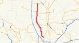
State Route 45 is a state highway
in the U.S. State
of California
that travels in a north–south direction from Route 113
in Knights Landing
to Route 32
in Hamilton City
.
.
The route begins at SR 113
in Knights Landing
in Yolo County
. It then heads northward and enters Colusa County
, where it has a short overlap with SR 20. It then enters Glenn County
, where it overlaps SR 162 through the cities of Codora
and Glenn
. It the continues northward to its end at SR 32
in Hamilton City
.
{| class=wikitable
!County
!Location
!Postmile
!Destinations
!Notes
|-
|rowspan=3|Yolo
YOL 0.00-12.92
|rowspan=2|Knights Landing
|0.00
|4th Street
|Continuation beyond SR 113
|-
|0.00
|
|
|-
|
|5.80
|
|
|-
|rowspan=5|Colusa
COL 0.00-34.18
|Grimes
|12.87
|Grimes-Arbuckle Road – College City
, Arbuckle
|
|-
|
|18.47
|Sycamore Road – Meridian
|
|-
|
|bgcolor=#ddffdd|19.85
36.79Indicates that the postmile represents the distance along SR 20 rather than SR 45.
|bgcolor=#ddffdd|
|bgcolor=#ddffdd|South end of SR 20 overlap
|-
|Colusa
|bgcolor=#ddffdd|31.09
19.86
|bgcolor=#ddffdd|
|bgcolor=#ddffdd|North end of SR 20 overlap
|-
|
|24.53
|.svg.png) Maxwell Road to I-5 – Maxwell
Maxwell Road to I-5 – Maxwell
|
|-
|rowspan=4|Glenn
GLE 0.00-23.23
|Codora
|bgcolor=#ddffdd|3.06
|bgcolor=#ddffdd|
|bgcolor=#ddffdd|South end of SR 162 overlap
|-
|Glenn
|bgcolor=#ddffdd|7.53
|bgcolor=#ddffdd|
|bgcolor=#ddffdd|North end of SR 162 overlap
|-
|rowspan=2|Hamilton City
|23.23
|
|
|-
|23.23
|Canal Street
|Continuation beyond SR 32
State highway
State highway, state road or state route can refer to one of three related concepts, two of them related to a state or provincial government in a country that is divided into states or provinces :#A...
in the U.S. State
U.S. state
A U.S. state is any one of the 50 federated states of the United States of America that share sovereignty with the federal government. Because of this shared sovereignty, an American is a citizen both of the federal entity and of his or her state of domicile. Four states use the official title of...
of California
California
California is a state located on the West Coast of the United States. It is by far the most populous U.S. state, and the third-largest by land area...
that travels in a north–south direction from Route 113
California State Route 113
State Route 113 is a north–south state highway in the U.S. state of California that runs from around west of Rio Vista at State Route 12 to State Route 99 south of Yuba City. It is an important connecting route between Interstate 80 and Interstate 5. Past the southern terminus are...
in Knights Landing
Knights Landing, California
Knights Landing is a census-designated place in Yolo County, California, USA founded by William Knight. It is located on the Sacramento River in the northeastern portion of the county. Knights Landing's ZIP Code is 95645 and its area code 530. It lies at an elevation of 36 feet...
to Route 32
California State Route 32
State Route 32 is an east–west state highway in the U.S. State of California which is routed from Interstate 5 in Orland, through Chico, through the northern Sierra Nevada, ending at SR 36 and SR 89 in eastern Tehama County.-Route description:...
in Hamilton City
Hamilton City, California
Hamilton City is a census-designated place in Glenn County, California, United States. The population was 1,759 at the 2010 census, down from 1,903 at the 2000 census. Hamilton City is located east of Orland, and 10 miles west of Chico at an elevation of 151 feet . The default numbers used for...
.
Route description
This route is part of the California Freeway and Expressway SystemCalifornia Freeway and Expressway System
The California Freeway and Expressway System is a system of existing or planned freeways and expressways in the U.S. state of California. It is defined by the Streets and Highways Code.-List of roads in the system:*State Route 1 *State Route 2...
.
The route begins at SR 113
California State Route 113
State Route 113 is a north–south state highway in the U.S. state of California that runs from around west of Rio Vista at State Route 12 to State Route 99 south of Yuba City. It is an important connecting route between Interstate 80 and Interstate 5. Past the southern terminus are...
in Knights Landing
Knights Landing, California
Knights Landing is a census-designated place in Yolo County, California, USA founded by William Knight. It is located on the Sacramento River in the northeastern portion of the county. Knights Landing's ZIP Code is 95645 and its area code 530. It lies at an elevation of 36 feet...
in Yolo County
Yolo County, California
Yolo County is a county located in the northern part of the U.S. state of California, bordered by the other counties of Sacramento, Solano, Napa, Lake, Colusa, and Sutter. The city of Woodland is its county seat, though Davis is its largest city....
. It then heads northward and enters Colusa County
Colusa County, California
Colusa County is a county located in the Central Valley of the U.S. state of California, northwest of state capital Sacramento. As of the 2010 census, its population was 21,419. The county seat is Colusa.-History:...
, where it has a short overlap with SR 20. It then enters Glenn County
Glenn County, California
Glenn County is in the California Central Valley. As of 2010, it had a population of 28,122. The county seat is the city of Willows.-History:Glenn County was formed in 1891 from parts of Colusa County. It was named for Dr. Hugh J...
, where it overlaps SR 162 through the cities of Codora
Codora, California
Codora is an unincorporated community in Glenn County, California. It is located on the Southern Pacific Railroad east-southeast of Willows, at an elevation of 89 feet ....
and Glenn
Glenn, California
Glenn is an unincorporated community in Glenn County, California. It lies at an elevation of 98 feet .. The town is located on the Sacramento River, at the intersection of State Route 45 and State Route 162. It is about ten miles east of Interstate 5 and Willows on the U.S. Geological Survey...
. It the continues northward to its end at SR 32
California State Route 32
State Route 32 is an east–west state highway in the U.S. State of California which is routed from Interstate 5 in Orland, through Chico, through the northern Sierra Nevada, ending at SR 36 and SR 89 in eastern Tehama County.-Route description:...
in Hamilton City
Hamilton City, California
Hamilton City is a census-designated place in Glenn County, California, United States. The population was 1,759 at the 2010 census, down from 1,903 at the 2000 census. Hamilton City is located east of Orland, and 10 miles west of Chico at an elevation of 151 feet . The default numbers used for...
.
Major intersections
- Note: Except where prefixed with a letter, postmiles were measured in 1964, based on the alignment as it existed at that time, and do not necessarily reflect current mileage. The numbers reset at county lines; the start and end postmiles in each county are given in the county column.
{| class=wikitable
!County
!Location
!Postmile
!Destinations
!Notes
|-
|rowspan=3|Yolo
Yolo County, California
Yolo County is a county located in the northern part of the U.S. state of California, bordered by the other counties of Sacramento, Solano, Napa, Lake, Colusa, and Sutter. The city of Woodland is its county seat, though Davis is its largest city....
YOL 0.00-12.92
|rowspan=2|Knights Landing
Knights Landing, California
Knights Landing is a census-designated place in Yolo County, California, USA founded by William Knight. It is located on the Sacramento River in the northeastern portion of the county. Knights Landing's ZIP Code is 95645 and its area code 530. It lies at an elevation of 36 feet...
|0.00
|4th Street
|Continuation beyond SR 113
|-
|0.00
|
|
|-
|
|5.80
|
|
|-
|rowspan=5|Colusa
Colusa County, California
Colusa County is a county located in the Central Valley of the U.S. state of California, northwest of state capital Sacramento. As of the 2010 census, its population was 21,419. The county seat is Colusa.-History:...
COL 0.00-34.18
|Grimes
Grimes, California
Grimes is a census-designated place in Colusa County, California on the Southern Pacific Railroad. It lies at an elevation of 46 feet . Its zip code is 95950 and its area code is 530. Grimes's population was 391 at the 2010 census.-History:The post office was established in 1883...
|12.87
|Grimes-Arbuckle Road – College City
College City, California
College City is a census-designated place in Colusa County, California. It lies at an elevation of 72 feet . Its zip code is 95912 and its area code is 530. College City's population is 290.-History:The post office was established in 1873...
, Arbuckle
Arbuckle, California
Arbuckle is a census-designated place in Colusa County, California, United States. The population was 3,028 at the 2010 census, up from 2,332 at the 2000 census. The town entrance sign on I-5 only says 864 people, but it's very old and hasn't been updated...
|
|-
|
|18.47
|Sycamore Road – Meridian
Meridian, California
Meridian is a census-designated place in Sutter County, California. Meridian sits at an elevation of . It is in the Yuba City Metropolitan Statistical Area. The ZIP Code is 95957. The community is inside area code 530...
|
|-
|
|bgcolor=#ddffdd|19.85
36.79Indicates that the postmile represents the distance along SR 20 rather than SR 45.
|bgcolor=#ddffdd|
|bgcolor=#ddffdd|South end of SR 20 overlap
|-
|Colusa
Colusa, California
Colusa is the county seat of Colusa County, California. The population was 5,971 at the 2010 census, up from 5,402 at the 2000 census.-Geography:...
|bgcolor=#ddffdd|31.09
19.86
|bgcolor=#ddffdd|
|bgcolor=#ddffdd|North end of SR 20 overlap
|-
|
|24.53
|
Maxwell, California
Maxwell is a census-designated place and farm community in Colusa County, California. It lies at an elevation of 92 feet . Located off Interstate 5, it is home to Maxwell High School. The main crop grown is rice, though a variety of others such as grapes, almonds, squash, and sunflowers are grown...
|
|-
|rowspan=4|Glenn
Glenn County, California
Glenn County is in the California Central Valley. As of 2010, it had a population of 28,122. The county seat is the city of Willows.-History:Glenn County was formed in 1891 from parts of Colusa County. It was named for Dr. Hugh J...
GLE 0.00-23.23
|Codora
Codora, California
Codora is an unincorporated community in Glenn County, California. It is located on the Southern Pacific Railroad east-southeast of Willows, at an elevation of 89 feet ....
|bgcolor=#ddffdd|3.06
|bgcolor=#ddffdd|
|bgcolor=#ddffdd|South end of SR 162 overlap
|-
|Glenn
Glenn, California
Glenn is an unincorporated community in Glenn County, California. It lies at an elevation of 98 feet .. The town is located on the Sacramento River, at the intersection of State Route 45 and State Route 162. It is about ten miles east of Interstate 5 and Willows on the U.S. Geological Survey...
|bgcolor=#ddffdd|7.53
|bgcolor=#ddffdd|
|bgcolor=#ddffdd|North end of SR 162 overlap
|-
|rowspan=2|Hamilton City
Hamilton City, California
Hamilton City is a census-designated place in Glenn County, California, United States. The population was 1,759 at the 2010 census, down from 1,903 at the 2000 census. Hamilton City is located east of Orland, and 10 miles west of Chico at an elevation of 151 feet . The default numbers used for...
|23.23
|
|
|-
|23.23
|Canal Street
|Continuation beyond SR 32