
California State Route 34
Encyclopedia
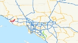
State Route 34 is a short state highway
in the U.S. state
of California
.
.
It starts on the west at the intersection of Oxnard Boulevard (Route 1
) and Fifth Street in Oxnard
. It continues east then northeast on Fifth Street until it intersects Pleasant Valley Road in Camarillo
. After continuing east on Pleasant Valley Road a short distance, it turns north onto Lewis Road until the intersection with Las Posas Road at the north city limit of Camarillo where Route 34 continues straight ahead as Somis Road. It ends at Route 118
near Somis
. This route originally began in Port Hueneme
, but in 1965, the portion from Port Hueneme to Route 1
was deleted. Nevertheless, Route 34 mileposts add on these additional 4 miles (6.4 km) along the signed route.
The entire route is in Ventura County
.
{| class=wikitable
!Location
!Postmile
!Destinations
!Notes
|-
|rowspan=4|Oxnard
|0.00
|Fifth Street
|Continuation beyond SR 1
|-
|0.00
|
|
|-
|5.28
|Rose Avenue
|
|-
|6.27
| Rice Avenue to SR 1
/ US 101
|
|-
|
|10.43
| Las Posas Road to SR 1
/ US 101 – Camarillo
, Point Mugu
, Port Hueneme
, CSU Channel Islands
|
|-
|rowspan=4|Camarillo
|12.78
| Lewis Road, Pleasant Valley Road to US 101 south – Point Mugu
, CSU Channel Islands
|
|-
|R13.54
|Ventura Boulevard
|
|-
|13.60
|
|Interchange
|-
|15.87
|Las Posas Road, Upland Road
|
|-
|Somis
|17.66
|
|
State highway
State highway, state road or state route can refer to one of three related concepts, two of them related to a state or provincial government in a country that is divided into states or provinces :#A...
in the U.S. state
U.S. state
A U.S. state is any one of the 50 federated states of the United States of America that share sovereignty with the federal government. Because of this shared sovereignty, an American is a citizen both of the federal entity and of his or her state of domicile. Four states use the official title of...
of California
California
California is a state located on the West Coast of the United States. It is by far the most populous U.S. state, and the third-largest by land area...
.
Route description
SR 34 is part of the California Freeway and Expressway SystemCalifornia Freeway and Expressway System
The California Freeway and Expressway System is a system of existing or planned freeways and expressways in the U.S. state of California. It is defined by the Streets and Highways Code.-List of roads in the system:*State Route 1 *State Route 2...
.
It starts on the west at the intersection of Oxnard Boulevard (Route 1
California State Route 1
State Route 1 , more often called Highway 1, is a state highway that runs along much of the Pacific coast of the U.S. state of California. It is famous for running along some of the most beautiful coastlines in the world, leading to its designation as an All-American Road.Highway 1 does not run...
) and Fifth Street in Oxnard
Oxnard, California
Oxnard is the 113th largest city in the United States, 19th largest city in California and largest city in Ventura County, California, by way of population. It is located at the western edge of the fertile Oxnard Plain, and is an important agricultural center, with its distinction as the...
. It continues east then northeast on Fifth Street until it intersects Pleasant Valley Road in Camarillo
Camarillo, California
Camarillo is a city in Ventura County, California, United States. The population was 65,201 at the 2010 census, up from 57,084 at the 2000 census. The Ventura Freeway Camarillo is a city in Ventura County, California, United States. The population was 65,201 at the 2010 census, up from 57,084 at...
. After continuing east on Pleasant Valley Road a short distance, it turns north onto Lewis Road until the intersection with Las Posas Road at the north city limit of Camarillo where Route 34 continues straight ahead as Somis Road. It ends at Route 118
California State Route 118
State Route 118 is a state highway in the U.S. state of California that begins running west to east through Ventura and Los Angeles counties in southern California. It travels from Saticoy in Ventura County east to Lake View Terrace in Los Angeles...
near Somis
Somis, California
Somis is an unincorporated area of Ventura County, California, just north of the Camarillo city limits. Its generally recognized boundaries are the areas around the intersection of Somis Road and Los Angeles Avenue , the latter being the dividing line between uptown and downtown. Its official...
. This route originally began in Port Hueneme
Port Hueneme, California
Port Hueneme is a small beach city in Ventura County, California surrounded by the city of Oxnard and the Pacific Ocean. The name derives from the Spanish spelling of the Chumash wene me, meaning "Resting Place". The area was discovered by Juan Rodríguez Cabrillo in the mid 16th century...
, but in 1965, the portion from Port Hueneme to Route 1
California State Route 1
State Route 1 , more often called Highway 1, is a state highway that runs along much of the Pacific coast of the U.S. state of California. It is famous for running along some of the most beautiful coastlines in the world, leading to its designation as an All-American Road.Highway 1 does not run...
was deleted. Nevertheless, Route 34 mileposts add on these additional 4 miles (6.4 km) along the signed route.
Future
According to the 2003 Caltrans District 7 Master System Plan Status Map, the segment of California Route 34 on Fifth Street and Pleasant Valley Road will be relocated to a north–south alignment beginning near Calleguas Creek opposite the Naval Air Weapons Station, Point Mugu on California Route 1 and ending near the intersection of Lewis and Pleasant Valley roads.Major intersections
- Note: Except where prefixed with a letter, postmiles were measured in 1964, based on the alignment as it existed at that time, and do not necessarily reflect current mileage.
The entire route is in Ventura County
Ventura County, California
Ventura County is a county in the southern part of the U.S. state of California. It is located on California's Pacific coast. It is often referred to as the Gold Coast, and has a reputation of being one of the safest populated places and one of the most affluent places in the country...
.
{| class=wikitable
!Location
!Postmile
!Destinations
!Notes
|-
|rowspan=4|Oxnard
Oxnard, California
Oxnard is the 113th largest city in the United States, 19th largest city in California and largest city in Ventura County, California, by way of population. It is located at the western edge of the fertile Oxnard Plain, and is an important agricultural center, with its distinction as the...
|0.00
|Fifth Street
|Continuation beyond SR 1
|-
|0.00
|
|
|-
|5.28
|Rose Avenue
|
|-
|6.27
| Rice Avenue to SR 1
California State Route 1
State Route 1 , more often called Highway 1, is a state highway that runs along much of the Pacific coast of the U.S. state of California. It is famous for running along some of the most beautiful coastlines in the world, leading to its designation as an All-American Road.Highway 1 does not run...
/ US 101
|
|-
|
|10.43
| Las Posas Road to SR 1
California State Route 1
State Route 1 , more often called Highway 1, is a state highway that runs along much of the Pacific coast of the U.S. state of California. It is famous for running along some of the most beautiful coastlines in the world, leading to its designation as an All-American Road.Highway 1 does not run...
/ US 101 – Camarillo
Camarillo, California
Camarillo is a city in Ventura County, California, United States. The population was 65,201 at the 2010 census, up from 57,084 at the 2000 census. The Ventura Freeway Camarillo is a city in Ventura County, California, United States. The population was 65,201 at the 2010 census, up from 57,084 at...
, Point Mugu
Point Mugu, California
Point Mugu , California is an unincorporated area and geographical promontory on the Pacific coast in Ventura County, near the town of Port Hueneme and the city of Oxnard. The name is believed to be derived from the Chumash Indian term Muwu, meaning beach, which was first mentioned by Cabrillo in...
, Port Hueneme
Port Hueneme, California
Port Hueneme is a small beach city in Ventura County, California surrounded by the city of Oxnard and the Pacific Ocean. The name derives from the Spanish spelling of the Chumash wene me, meaning "Resting Place". The area was discovered by Juan Rodríguez Cabrillo in the mid 16th century...
, CSU Channel Islands
California State University, Channel Islands
California State University Channel Islands is a four-year public university located in Camarillo, California, in Ventura County. CSUCI opened in 2002 as the 23rd campus in the California State University system, succeeding the Ventura County branch campus of CSU Northridge...
|
|-
|rowspan=4|Camarillo
Camarillo, California
Camarillo is a city in Ventura County, California, United States. The population was 65,201 at the 2010 census, up from 57,084 at the 2000 census. The Ventura Freeway Camarillo is a city in Ventura County, California, United States. The population was 65,201 at the 2010 census, up from 57,084 at...
|12.78
| Lewis Road, Pleasant Valley Road to US 101 south – Point Mugu
Point Mugu, California
Point Mugu , California is an unincorporated area and geographical promontory on the Pacific coast in Ventura County, near the town of Port Hueneme and the city of Oxnard. The name is believed to be derived from the Chumash Indian term Muwu, meaning beach, which was first mentioned by Cabrillo in...
, CSU Channel Islands
California State University, Channel Islands
California State University Channel Islands is a four-year public university located in Camarillo, California, in Ventura County. CSUCI opened in 2002 as the 23rd campus in the California State University system, succeeding the Ventura County branch campus of CSU Northridge...
|
|-
|R13.54
|Ventura Boulevard
|
|-
|13.60
|
|Interchange
|-
|15.87
|Las Posas Road, Upland Road
|
|-
|Somis
Somis, California
Somis is an unincorporated area of Ventura County, California, just north of the Camarillo city limits. Its generally recognized boundaries are the areas around the intersection of Somis Road and Los Angeles Avenue , the latter being the dividing line between uptown and downtown. Its official...
|17.66
|
|