
CLidar
Encyclopedia
The CLidar is a scientific instrument used for measuring particulates (aerosols) in the lower atmosphere. CLidar stands for camera lidar
, which in turn is an acronym for LIght Detection And Ranging. It is a form of remote sensing
and used for atmospheric physics
.
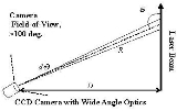
) camera. The camera is positioned hundreds of meters away from the (usually vertically-pointed) laser beam. The geometry of the CLidar is shown in the figure. It is important in the analysis that the optics, the wide-angle lens in this case, accurately maps equal angles onto an equal number of pixels throughout the 100 degree field-of-view.

Disadvantages include poor altitude resolution in the upper atmosphere, difficulty designing optics that gathers substantial amounts of light, and a loss in noise rejection (signal-to-noise ratio
).
LIDAR
LIDAR is an optical remote sensing technology that can measure the distance to, or other properties of a target by illuminating the target with light, often using pulses from a laser...
, which in turn is an acronym for LIght Detection And Ranging. It is a form of remote sensing
Remote sensing
Remote sensing is the acquisition of information about an object or phenomenon, without making physical contact with the object. In modern usage, the term generally refers to the use of aerial sensor technologies to detect and classify objects on Earth by means of propagated signals Remote sensing...
and used for atmospheric physics
Atmospheric physics
Atmospheric physics is the application of physics to the study of the atmosphere. Atmospheric physicists attempt to model Earth's atmosphere and the atmospheres of the other planets using fluid flow equations, chemical models, radiation balancing, and energy transfer processes in the atmosphere...
.
Description
In this technique a very wide-angle lens images light scattered from a laser beam onto a CCD (Charge-coupled deviceCharge-coupled device
A charge-coupled device is a device for the movement of electrical charge, usually from within the device to an area where the charge can be manipulated, for example conversion into a digital value. This is achieved by "shifting" the signals between stages within the device one at a time...
) camera. The camera is positioned hundreds of meters away from the (usually vertically-pointed) laser beam. The geometry of the CLidar is shown in the figure. It is important in the analysis that the optics, the wide-angle lens in this case, accurately maps equal angles onto an equal number of pixels throughout the 100 degree field-of-view.
Example
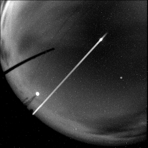
In the second figure, an image from the CCD camera is shown which is analyzed by adding up the individual pixels at each altitude.The camera was 122 meters from the vertically pointed, circularly-polarized laser beam. The beam is brighter near the ground due to near-ground aerosols. A bright spot due to a cloud can be seen near the top of the beam. The beam was positioned diagonally on the CCD array to use the space more effectively. A lighthouse and power pole can also be seen in the image.Differences between Lidar and CLidar
The CLidar technique has the advantage over the lidar technique of being able to measure all the way to the ground. The signal strength is also much more constant than a lidar signal which can change by many orders of magnitude. It has very high altitude resolution in the lower atmosphere. The instrument components are typically simpler than those in the lidar also.Disadvantages include poor altitude resolution in the upper atmosphere, difficulty designing optics that gathers substantial amounts of light, and a loss in noise rejection (signal-to-noise ratio
Signal-to-noise ratio
Signal-to-noise ratio is a measure used in science and engineering that compares the level of a desired signal to the level of background noise. It is defined as the ratio of signal power to the noise power. A ratio higher than 1:1 indicates more signal than noise...
).