
Burnley Wood
Encyclopedia
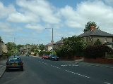
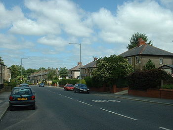
Burnley Wood is a district of Burnley
, Lancashire
. In broad terms it lies between Parliament Street in the north and Stoney Street in the south, and from the railway in the west to Todmorden Road in the east.
 In the sixteenth-century, as the name suggests, the area was mostly covered by rough moorland and woodland, with a scattering of farmsteads on the outskirts of Burnley proper: Whittaker Farm (at the junction of modern day Hufling Lane and Todmorden Road), Moseley Farm (on what is now Glebe Street), Hufling Hall, and Hollingreave House (at the junction of modern day Brunswick Street and Hollingreave Road). Todmorden Road, which became a turnpike
road in 1817, dates from this period. From 1673 to 1819, the majority of Burnley Wood was glebe land
in the ownership of St Peter's Church, and as such could not be developed. By 1825, the first development had appeared: back-to-back
cottages and mills along the canal at Finsley Gate. Between 1825 and 1844 Spring Gardens Mill, together with back-to-back cottages, were built between Plumbe Street and Eastgate (now Yorkshire Street); several large houses in extensive grounds were built along the western side of Todmorden Road; a small hamlet developed around the Woodman Inn at the junction of Todmorden Road and Hufling Lane; and further up Hufling Lane, a row of cottages known as 'Organ Row' were built near the railway line. In the second half of the nineteenth century, widespread development occurred with two distinct characters: large stone-built houses in spacious grounds, flanking Brooklands Road and Todmorden Road, and high density terraced housing, mills and associated buildings, largely built between 1860 and 1890 in the area between Hufling Lane, the canal, the railway, Oxford Road and Todmorden Road. These houses essentially form today's housing stock in the area, with some limited modern infill.
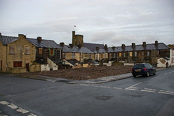 In recent years, Burnley Wood has suffered from housing market failure, and is now part of East Lancashire's Elevate
scheme to clear, rebuild
or remodel
sub-standard housing. It lies in the Rosehill with Burnley Wood ward
, which is 96.86% White. The index of multiple deprivation places part of Burnley Wood among the 5% most deprived areas in the country, while parts of neighbouring Rosehill in contrast are more affluent than the national average. 21.41% of children in the ward are eligible for free school meals.
The area has a traditionally strong local identity. An active community group, Burnley Wood Community Action Group, publishes a free newspaper, the Burnley Wood Argus, for the area, and Burnley Wood Park, a new community park financed by Elevate, has been built in the centre of the housing clearance area. Previously high crime levels, especially antisocial behaviour
by young people, now appear to be in decline: there were 114 crimes per 1,000 inhabitants in the year to December 2007 (Lancashire
average 89.4), a fall of 19.2% on the previous twelve months.
Burnley
Burnley is a market town in the Burnley borough of Lancashire, England, with a population of around 73,500. It lies north of Manchester and east of Preston, at the confluence of the River Calder and River Brun....
, Lancashire
Lancashire
Lancashire is a non-metropolitan county of historic origin in the North West of England. It takes its name from the city of Lancaster, and is sometimes known as the County of Lancaster. Although Lancaster is still considered to be the county town, Lancashire County Council is based in Preston...
. In broad terms it lies between Parliament Street in the north and Stoney Street in the south, and from the railway in the west to Todmorden Road in the east.
History
Turnpike trust
Turnpike trusts in the United Kingdom were bodies set up by individual Acts of Parliament, with powers to collect road tolls for maintaining the principal highways in Britain from the 17th but especially during the 18th and 19th centuries...
road in 1817, dates from this period. From 1673 to 1819, the majority of Burnley Wood was glebe land
Glebe
Glebe Glebe Glebe (also known as Church furlong or parson's closes is an area of land within a manor and parish used to support a parish priest.-Medieval origins:...
in the ownership of St Peter's Church, and as such could not be developed. By 1825, the first development had appeared: back-to-back
Back-to-back houses
Usually of low quality and high density, they were built for working class people and because three of the four walls of the house were shared with other buildings and therefore contained no doors or windows, back-to-back houses were notoriously ill-lit and poorly ventilated and sanitation was of...
cottages and mills along the canal at Finsley Gate. Between 1825 and 1844 Spring Gardens Mill, together with back-to-back cottages, were built between Plumbe Street and Eastgate (now Yorkshire Street); several large houses in extensive grounds were built along the western side of Todmorden Road; a small hamlet developed around the Woodman Inn at the junction of Todmorden Road and Hufling Lane; and further up Hufling Lane, a row of cottages known as 'Organ Row' were built near the railway line. In the second half of the nineteenth century, widespread development occurred with two distinct characters: large stone-built houses in spacious grounds, flanking Brooklands Road and Todmorden Road, and high density terraced housing, mills and associated buildings, largely built between 1860 and 1890 in the area between Hufling Lane, the canal, the railway, Oxford Road and Todmorden Road. These houses essentially form today's housing stock in the area, with some limited modern infill.
Today
Housing Market Renewal Initiative
The Housing Market Renewal Initiative is a package of policies in the North of England aimed to address housing market failure, which was defined as housing which in local markets was priced below the build cost, such that renovations were uneconomic and the sale of property would not generate...
scheme to clear, rebuild
Demolition
Demolition is the tearing-down of buildings and other structures, the opposite of construction. Demolition contrasts with deconstruction, which involves taking a building apart while carefully preserving valuable elements for re-use....
or remodel
Renovation
Renovation is the process of improving a structure. Two prominent types of renovations are commercial and residential.-Process:The process of a renovation, however complex, can usually be broken down into several processes...
sub-standard housing. It lies in the Rosehill with Burnley Wood ward
Wards of the United Kingdom
A ward in the United Kingdom is an electoral district at sub-national level represented by one or more councillors. It is the primary unit of British administrative and electoral geography .-England:...
, which is 96.86% White. The index of multiple deprivation places part of Burnley Wood among the 5% most deprived areas in the country, while parts of neighbouring Rosehill in contrast are more affluent than the national average. 21.41% of children in the ward are eligible for free school meals.
The area has a traditionally strong local identity. An active community group, Burnley Wood Community Action Group, publishes a free newspaper, the Burnley Wood Argus, for the area, and Burnley Wood Park, a new community park financed by Elevate, has been built in the centre of the housing clearance area. Previously high crime levels, especially antisocial behaviour
Anti-social behaviour
Anti-social behaviour is behaviour that lacks consideration for others and that may cause damage to society, whether intentionally or through negligence, as opposed to pro-social behaviour, behaviour that helps or benefits society...
by young people, now appear to be in decline: there were 114 crimes per 1,000 inhabitants in the year to December 2007 (Lancashire
Lancashire
Lancashire is a non-metropolitan county of historic origin in the North West of England. It takes its name from the city of Lancaster, and is sometimes known as the County of Lancaster. Although Lancaster is still considered to be the county town, Lancashire County Council is based in Preston...
average 89.4), a fall of 19.2% on the previous twelve months.
External links
- 360° photographic panorama of housing clearance area
- Burnley Wood Community Action Group
- Dall Street Residents' Association (not updated since January 2006)
- Information on housing renewal in the area from Burnley Borough Council
- Springfield Community Primary School
- St Stephen's Parish Church
- Sure Start Duke Bar & Burnley Wood