
Breamlea, Victoria
Encyclopedia
Breamlea, Victoria
, Australia
, is a secluded seaside hamlet located 28 km south of Geelong on the south coast of Australia halfway between Barwon Heads
and Torquay
on the Bellarine Peninsula
. At the 2006 census
, Breamlea and the surrounding area had a population of 244.
.
Thomsons Creek runs through a natural lattice of reedy canals and widens before it enters Buckleys Bay. At the mouth of Thomsons Creek is Point Impossible which is a well-known longboard surfing
break.
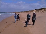
The patrolled surf beach at Breamlea is called Bancoora on Bass Strait
, and is the closest surf beach to Melbourne. The beach was named after the steamship SS Bancoora that ran aground on the same beach in 1881. The non-patrolled beaches along this stretch of coast are not heavily used and are often empty.
. The rocks in the area have always been rich in shellfish and large middens of the discarded shells can be seen on the headland between Buckley's Bay and Stingray Bay. William Buckley
lived in this area and across the road from the caravan park is the well that he was supposed to have used.
On 14 July 1891 the steamship SS Bancoora ran aground on what is now the surf beach. The cargo included a young elephant. rhinoceros, monkeys and parrots. All were landed safely and taken by truck to Geelong. The rhinoceros unfortunately only lasted 2 days. The wreck was sold for breaking up in 1906.
Thompsons Creek attracted campers and fishermen from the 1870s onwards and by the 1920s, makeshift huts were built by regular campers. During the 1930s depression, squatters made permanent buildings, rent-free, and eked meals from the creek and the ocean. Freehold land was not subdivided for sale until 1942, creating boundaries to a small linear township huddled behind the high, ti-tree covered sand dunes. The Post Office opened on 1 July 1947.
In 1962 the surf life saving club was formed at Bancoora Beach, with clubrooms being built in 1963. On 8 April 1987 the original clubhouse was guttered by fire. For the next 4 season the club operated from a tin shed, until the present building was completed and opened on 25 October 1992.
There is also a caravan park and small general store with basic supplies. Halfway along Horwood Drive there is a recreation reserve with an oval, children's playground, barbecue facilities and toilet.
The area is underdeveloped and many of the residents wish to keep it this way. The architecture of Breamlea is mix of fibro-cement
beach shacks built in the 1950s and 1960s, and modern architect designed houses.
Black Rock sewage treatment
plant is located to the north east of Breamlea, handing effluent from Geelong and surrounding suburbs. Black Rock was first chosen as the ocean outfall for Geelong
's sewage in 1912, with a sewer being built during the next three years. Initially the sewage was left untreated before being discharged into the ocean, polluting several beaches downstream on the prevailing ocean currents. A primary filtration system was installed in the 1970s, and in the 1980s the current plant was built with an upgraded filtration system, along with a 1.2 kilometre long ocean outfall. 1997 saw an upgrade to the plant, with secondary filtration introduced, and a pipeline installed to transport recycled water to the flower farm at Torquay
.
Each summer a nipper program is run to educate and enhance the surf skills of young members.
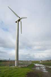 The wind generator
located on Black Rock Road is owned by local water utility Barwon Water
. Today it outputs approximately 80,000 kWh per year to the grid, with an estimated 90-95 per cent availability. The generator was erected in November 1987 as a demonstration unit by the State Electricity Commission of Victoria
and the Victorian Solar Energy Council (now Energy Victoria), the turbine was of 60 kW capacity atop a 22 metre monopole, and was manufactured by Westwind
of Western Australia
. Between 7 kW and 10.3 kW of average power has been produced by the generator.
As part of the privatisation of electricity supply in Victoria, the generator was sold in 1994 to the Alternative Technology Association of Melbourne
. December 1995 saw the generator sold again, to a Mr Michael Gunter, a member of the previous organisation. Electricity production ceased at 1200hrs on 17 May 2003 due to a electrical generator
burn-out, caused by moisture, salt, and electrical flash-over. Barwon Water bought the turbine the same year, restoring it to service in early 2004.
Victoria (Australia)
Victoria is the second most populous state in Australia. Geographically the smallest mainland state, Victoria is bordered by New South Wales, South Australia, and Tasmania on Boundary Islet to the north, west and south respectively....
, Australia
Australia
Australia , officially the Commonwealth of Australia, is a country in the Southern Hemisphere comprising the mainland of the Australian continent, the island of Tasmania, and numerous smaller islands in the Indian and Pacific Oceans. It is the world's sixth-largest country by total area...
, is a secluded seaside hamlet located 28 km south of Geelong on the south coast of Australia halfway between Barwon Heads
Barwon Heads, Victoria
Barwon Heads is a coastal township on the Bellarine Peninsula, near Geelong, Victoria, Australia. It is situated on the west bank of the mouth of the Barwon River below Lake Connewarre, while it is bounded to the west by farmland, golf courses and the ephemeral saline wetland Murtnaghurt...
and Torquay
Torquay, Victoria
Torquay is a township in Victoria, Australia, which faces Bass Strait, 21 km. south of Geelong and is the gateway to the Great Ocean Road. It is bordered on the west by Spring Creek and its coastal features include Point Danger and Zeally Bay...
on the Bellarine Peninsula
Bellarine Peninsula
The Bellarine Peninsula is a peninsula located south-west of Melbourne in Victoria, Australia, surrounded by Port Phillip, Corio Bay and Bass Strait. The peninsula, together with the Mornington Peninsula separates Port Phillip from Bass Strait...
. At the 2006 census
Census in Australia
The Australian census is administered once every five years by the Australian Bureau of Statistics. The most recent census was conducted on 9 August 2011; the next will be conducted in 2016. Prior to the introduction of regular censuses in 1961, they had also been run in 1901, 1911, 1921, 1933,...
, Breamlea and the surrounding area had a population of 244.
Geography
Breamlea is nestled in the sand dunes between Thomsons Creek and the beach. The nearest township to Breamlea is ConnewarreConnewarre, Victoria
Connewarre, Victoria, Australia, is located in southern Australia in an area that is sparsely populated. At the 2006 census, Connewarre and the surrounding area had a population of 78....
.
Thomsons Creek runs through a natural lattice of reedy canals and widens before it enters Buckleys Bay. At the mouth of Thomsons Creek is Point Impossible which is a well-known longboard surfing
Surfing
Surfing' is a surface water sport in which the surfer rides a surfboard on the crest and face of a wave which is carrying the surfer towards the shore...
break.
The patrolled surf beach at Breamlea is called Bancoora on Bass Strait
Bass Strait
Bass Strait is a sea strait separating Tasmania from the south of the Australian mainland, specifically the state of Victoria.-Extent:The International Hydrographic Organization defines the limits of the Bass Strait as follows:...
, and is the closest surf beach to Melbourne. The beach was named after the steamship SS Bancoora that ran aground on the same beach in 1881. The non-patrolled beaches along this stretch of coast are not heavily used and are often empty.
History
The Breamlea area was once populated by the Mon Mart Clan of Wathaurong peopleWautharong
Wathaurong, also called the Wada wurrung, are an Indigenous Australian tribe living in the area near Melbourne, Geelong and the Bellarine Peninsula. They are part of the Kulin alliance. The Wathaurong language was spoken by 25 clans south of the Werribee River and the Bellarine Peninsula to Streatham...
. The rocks in the area have always been rich in shellfish and large middens of the discarded shells can be seen on the headland between Buckley's Bay and Stingray Bay. William Buckley
William Buckley (convict)
William Buckley was an English convict who was transported to Australia, escaped, was given up for dead and lived in an Aboriginal community for many years....
lived in this area and across the road from the caravan park is the well that he was supposed to have used.
On 14 July 1891 the steamship SS Bancoora ran aground on what is now the surf beach. The cargo included a young elephant. rhinoceros, monkeys and parrots. All were landed safely and taken by truck to Geelong. The rhinoceros unfortunately only lasted 2 days. The wreck was sold for breaking up in 1906.
Thompsons Creek attracted campers and fishermen from the 1870s onwards and by the 1920s, makeshift huts were built by regular campers. During the 1930s depression, squatters made permanent buildings, rent-free, and eked meals from the creek and the ocean. Freehold land was not subdivided for sale until 1942, creating boundaries to a small linear township huddled behind the high, ti-tree covered sand dunes. The Post Office opened on 1 July 1947.
In 1962 the surf life saving club was formed at Bancoora Beach, with clubrooms being built in 1963. On 8 April 1987 the original clubhouse was guttered by fire. For the next 4 season the club operated from a tin shed, until the present building was completed and opened on 25 October 1992.
Township
Breamlea has around 100 houses nestled in the dune between Thomsons Creek and the beach. The main road is Horwood Drive, which is located at the base, with Blyth Street above. Houses are located on the south side of Horwood Drive, and the north side of Blyth Street.There is also a caravan park and small general store with basic supplies. Halfway along Horwood Drive there is a recreation reserve with an oval, children's playground, barbecue facilities and toilet.
The area is underdeveloped and many of the residents wish to keep it this way. The architecture of Breamlea is mix of fibro-cement
Fibro
Fibro, the shortened form of "Fibrous Cement" - or "Fibrous Asbestos Cement", FAC, is a building material made of compressed fibres cemented into rigid sheets....
beach shacks built in the 1950s and 1960s, and modern architect designed houses.
Sewage outfall
Barwon Water'sBarwon Water
Barwon Water is a government owned statutory authority that controls much of the water system in Geelong, Victoria, Australia including the reservoirs, and the sewerage and drainage system that services the city and surrounding districts...
Black Rock sewage treatment
Sewage treatment
Sewage treatment, or domestic wastewater treatment, is the process of removing contaminants from wastewater and household sewage, both runoff and domestic. It includes physical, chemical, and biological processes to remove physical, chemical and biological contaminants...
plant is located to the north east of Breamlea, handing effluent from Geelong and surrounding suburbs. Black Rock was first chosen as the ocean outfall for Geelong
Geelong, Victoria
Geelong is a port city located on Corio Bay and the Barwon River, in the state of Victoria, Australia, south-west of the state capital; Melbourne. It is the second most populated city in Victoria and the fifth most populated non-capital city in Australia...
's sewage in 1912, with a sewer being built during the next three years. Initially the sewage was left untreated before being discharged into the ocean, polluting several beaches downstream on the prevailing ocean currents. A primary filtration system was installed in the 1970s, and in the 1980s the current plant was built with an upgraded filtration system, along with a 1.2 kilometre long ocean outfall. 1997 saw an upgrade to the plant, with secondary filtration introduced, and a pipeline installed to transport recycled water to the flower farm at Torquay
Torquay, Victoria
Torquay is a township in Victoria, Australia, which faces Bass Strait, 21 km. south of Geelong and is the gateway to the Great Ocean Road. It is bordered on the west by Spring Creek and its coastal features include Point Danger and Zeally Bay...
.
Bancoora Surf Life Saving Club
The Bancoora SLSC conduct seasonal surf patrols over the summer period, throughout January the beach has lifeguards on duty every day. Ben Pope is the current Club Captain and Nathan Morton the President.Each summer a nipper program is run to educate and enhance the surf skills of young members.
Wind generator
Wind generator
A wind generator is a device that generates electrical power from wind energy.Wind generators have traditionally been wind turbines, i.e. a propeller attached to an electric generator attached to appropriate electronics to attach it to the electrical grid or to charge batteries.Recently, however, a...
located on Black Rock Road is owned by local water utility Barwon Water
Barwon Water
Barwon Water is a government owned statutory authority that controls much of the water system in Geelong, Victoria, Australia including the reservoirs, and the sewerage and drainage system that services the city and surrounding districts...
. Today it outputs approximately 80,000 kWh per year to the grid, with an estimated 90-95 per cent availability. The generator was erected in November 1987 as a demonstration unit by the State Electricity Commission of Victoria
State Electricity Commission of Victoria
The State Electricity Commission of Victoria was a monopoly electricity generation, transmission and supply utility located in Victoria, Australia...
and the Victorian Solar Energy Council (now Energy Victoria), the turbine was of 60 kW capacity atop a 22 metre monopole, and was manufactured by Westwind
Westwind
Westwind may refer to:* IAI Westwind, a business jet* Westwind an IAI Westwind used as the Honduras Presidential Plane.* Call sign for West Wind Aviation - aviation company based in Saskatoon...
of Western Australia
Western Australia
Western Australia is a state of Australia, occupying the entire western third of the Australian continent. It is bounded by the Indian Ocean to the north and west, the Great Australian Bight and Indian Ocean to the south, the Northern Territory to the north-east and South Australia to the south-east...
. Between 7 kW and 10.3 kW of average power has been produced by the generator.
As part of the privatisation of electricity supply in Victoria, the generator was sold in 1994 to the Alternative Technology Association of Melbourne
Melbourne
Melbourne is the capital and most populous city in the state of Victoria, and the second most populous city in Australia. The Melbourne City Centre is the hub of the greater metropolitan area and the Census statistical division—of which "Melbourne" is the common name. As of June 2009, the greater...
. December 1995 saw the generator sold again, to a Mr Michael Gunter, a member of the previous organisation. Electricity production ceased at 1200hrs on 17 May 2003 due to a electrical generator
Electrical generator
In electricity generation, an electric generator is a device that converts mechanical energy to electrical energy. A generator forces electric charge to flow through an external electrical circuit. It is analogous to a water pump, which causes water to flow...
burn-out, caused by moisture, salt, and electrical flash-over. Barwon Water bought the turbine the same year, restoring it to service in early 2004.