

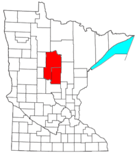
Brainerd micropolitan area
Encyclopedia
United States Census Bureau
The United States Census Bureau is the government agency that is responsible for the United States Census. It also gathers other national demographic and economic data...
, is an area consisting of two counties in central
Central Minnesota
Central Minnesota is the name of the region consisting of the central portion of the state of Minnesota. Although no specific boundaries of the region exist, most definitions of what makes up the region would generally consist of the vast swath of land north of Interstate 94, east of U.S. Highway...
Minnesota
Minnesota
Minnesota is a U.S. state located in the Midwestern United States. The twelfth largest state of the U.S., it is the twenty-first most populous, with 5.3 million residents. Minnesota was carved out of the eastern half of the Minnesota Territory and admitted to the Union as the thirty-second state...
, anchored by the city of Brainerd
Brainerd, Minnesota
Brainerd is a city in Crow Wing County, Minnesota, United States. The population was 13,590 at the 2010 census. It is the county seat of Crow Wing County and one of the largest cities in Central Minnesota...
. As of February 4th, 2011 estimate placed the population at 91,067).
Communities
- Places with more than 10,000 inhabitants
- BrainerdBrainerd, MinnesotaBrainerd is a city in Crow Wing County, Minnesota, United States. The population was 13,590 at the 2010 census. It is the county seat of Crow Wing County and one of the largest cities in Central Minnesota...
(Principal city)
- Brainerd
- Places with 1,000 to 10,000 inhabitants
- BaxterBaxter, MinnesotaAs of the census of 2000, there were 5,555 people, 1,921 households, and 1,586 families residing in the city. The population density was 320.7 people per square mile . There were 1,979 housing units at an average density of 114.3 per square mile...
- CrosbyCrosby, MinnesotaAs of the census of 2000, there were 2,299 people, 989 households, and 554 families residing in the city. The population density was 755.0 people per square mile . There were 1,081 housing units at an average density of 355.0 per square mile...
- CrosslakeCrosslake, MinnesotaAs of the census of 2000, there were 1,893 people, 899 households, and 623 families residing in the city. The population density was 73.8 people per square mile . There were 2,477 housing units at an average density of 96.6 per square mile...
- NisswaNisswa, MinnesotaAs of the census of 2000, there were 1,953 people, 819 households, and 577 families residing in the city. The population density was 179.5 people per square mile . There were 1,532 housing units at an average density of 140.8 per square mile...
- WalkerWalker, MinnesotaAs of the census of 2000, there were 1,069 people, 449 households, and 258 families residing in the city. The population density was 734.3 people per square mile . There were 517 housing units at an average density of 355.1 per square mile...
- Baxter
- Places with 500 to 1,000 inhabitants
- Breezy PointBreezy Point, MinnesotaAs of the census of 2000, there were 979 people, 413 households, and 306 families residing in the city. The population density was 74.7 people per square mile . There were 899 housing units at an average density of 68.6 per square mile...
- Cass LakeCass Lake, MinnesotaAs of the census of 2000, there were 860 people, 331 households, and 192 families residing in the city. The population density was 753.2 people per square mile . There were 384 housing units at an average density of 336.3 per square mile . The racial makeup of the city was 30.12% White, 64.42%...
- DeerwoodDeerwood, MinnesotaAs of the census of 2000, there were 590 people, 256 households, and 153 families residing in the city. The population density was 431.1 people per square mile . There were 309 housing units at an average density of 225.8 per square mile...
- East Gull LakeEast Gull Lake, MinnesotaAs of the census of 2000, there were 978 people, 370 households, and 294 families residing in the city. The population density was 123.6 people per square meter . There were 709 housing units at an average density of 89.6 per square mile...
- EmilyEmily, MinnesotaAs of the census of 2000, there were 847 people, 368 households, and 243 families residing in the city. The population density was 28.2 people per square mile . There were 876 housing units at an average density of 29.2 per square mile...
- Lake ShoreLake Shore, MinnesotaAs of the census of 2000, there were 966 people, 436 households, and 327 families residing in the city. The population density was 75.5 people per square mile . There were 858 housing units at an average density of 67.1 per square mile...
- MotleyMotley, MinnesotaAs of the census of 2000, there were 585 people, 258 households, and 167 families residing in the city. The population density was 442.7 people per square mile . There were 270 housing units at an average density of 204.3 per square mile...
(partial) - Pequot LakesPequot Lakes, MinnesotaAs of the census of 2000, there were 947 people, 479 households, and 231 families residing in the city. The population density was 653.8 people per square mile . There were 564 housing units at an average density of 389.4 per square mile...
- Pine RiverPine River, MinnesotaAs of the census of 2000, there were 928 people, 438 households, and 216 families residing in the city. The population density was 834.6 people per square mile . There were 464 housing units at an average density of 417.3 per square mile...
- Breezy Point
- Places with less than 500 inhabitants
- BackusBackus, MinnesotaBackus is a city in Cass County, Minnesota, United States. The population was 250 at the 2010 census. It is part of the Brainerd Micropolitan Statistical Area.-Geography:...
- BenaBena, MinnesotaAs of the census of 2000, there were 110 people, 48 households, and 31 families residing in the city. The population density was 218.0 people per square mile . There were 72 housing units at an average density of 142.7 per square mile...
- Boy RiverBoy River, MinnesotaBoy River is a city in Cass County, Minnesota, United States. The population was 47 at the 2010 census. It is part of the Brainerd Micropolitan Statistical Area.-Geography:...
- Chickamaw BeachChickamaw Beach, MinnesotaChickamaw Beach is a city in Cass County, Minnesota, United States. The population was 114 at the 2010 census. It is part of the Brainerd Micropolitan Statistical Area.-Geography:...
- CuyunaCuyuna, MinnesotaAs of the census of 2000, there were 231 people, 90 households, and 64 families residing in the city. The population density was 70.6 people per square mile . There were 113 housing units at an average density of 34.5 per square mile . The racial makeup of the city was 98.70% White, 0.87%...
- Federal DamFederal Dam, MinnesotaFederal Dam is a city in Cass County, Minnesota, United States. The population was 110 at the 2010 census. It is part of the Brainerd Micropolitan Statistical Area.-Geography:...
- Fifty LakesFifty Lakes, MinnesotaAs of the census of 2000, there were 392 people, 194 households, and 135 families residing in the city. The population density was 13.5 people per square mile . There were 515 housing units at an average density of 17.7 per square mile . The racial makeup of the city was 99.74% White and 0.26%...
- Fort RipleyFort Ripley, MinnesotaAs of the census of 2000, there were 74 people, 34 households, and 24 families residing in the city. The population density was 55.6 people per square mile . There were 35 housing units at an average density of 26.3 per square mile . The racial makeup of the city was 94.59% White, 1.35% Native...
- GarrisonGarrison, MinnesotaAs of the census of 2000, there were 213 people, 113 households, and 48 families residing in the city. The population density was 198.9 people per square mile . There were 191 housing units at an average density of 178.4 per square mile . The racial makeup of the city was 97.65% White, 0.94%...
- HackensackHackensack, MinnesotaHackensack is a city in Cass County, Minnesota, United States. The population was 313 at the 2010 census. It is part of the Brainerd Micropolitan Statistical Area.-Geography:...
- IrontonIronton, MinnesotaAs of the census of 2000, there were 498 people, 231 households, and 130 families residing in the city. The population density was 333.2 people per square mile . There were 263 housing units at an average density of 176.0 per square mile . The racial makeup of the city was 99.40% White, 0.40%...
- JenkinsJenkins, MinnesotaAs of the census of 2000, there were 287 people, 113 households, and 72 families residing in the city. The population density was 67.5 people per square mile . There were 123 housing units at an average density of 28.9 per square mile...
- LongvilleLongville, MinnesotaLongville is a city in Cass County, Minnesota, United States. The population was 156 at the 2010 census. The city was named after its founder Jim Long. The town is roughly 4 hours north of the Twin Cities. It is part of the Brainerd Micropolitan Statistical Area...
- Manhattan BeachManhattan Beach, MinnesotaAs of the census of 2000, there were 50 people, 22 households, and 15 families residing in the city. The population density was 33.1 people per square mile . There were 61 housing units at an average density of 40.3 per square mile...
- PillagerPillager, MinnesotaPillager is a city in Cass County, Minnesota, United States. The population was 469 at the 2010 census. It is part of the Brainerd Micropolitan Statistical Area.-Geography:...
- RemerRemer, MinnesotaRemer is a city in Cass County, Minnesota, United States. The population was 370 at the 2010 census. It is part of the Brainerd Micropolitan Statistical Area.Minnesota State Highways 6 and 200 are two of the main arterial routes in the community.-Geography:...
- RivertonRiverton, MinnesotaAs of the census of 2000, there were 115 people, 51 households, and 29 families residing in the city. The population density was 146.5 people per square mile . There were 61 housing units at an average density of 77.7 per square mile . The racial makeup of the city was 99.13% White and 0.87% Native...
- TrommaldTrommald, MinnesotaAs of the census of 2000, there were 125 people, 47 households, and 28 families residing in the village. The population density was 33.8 people per square mile . There were 52 housing units at an average density of 14.0 per square mile . The racial makeup of the village was 97.60% White, 0.80%...
- Backus
- Unorganized territories
- Dean LakeDean Lake, MinnesotaDean Lake is an unorganized territory in Crow Wing County, Minnesota, United States. The population was 89 at the 2000 census. It is part of the Brainerd Micropolitan Statistical Area.-Geography:...
- West Crow WingWest Crow Wing, MinnesotaWest Crow Wing is an unorganized territory in Crow Wing County, Minnesota, United States. The population was 5,144 at the 2000 census. It is part of the Brainerd Micropolitan Statistical Area.-Geography:...
- WahnenaWahnena, MinnesotaWahnena is an unorganized territory in Cass County, Minnesota, United States. The population was 197 at the 2000 census. It is part of the Brainerd Micropolitan Statistical Area.-Geography:...
- North CassNorth Cass, MinnesotaNorth Cass is an unorganized territory in Cass County, Minnesota, United States. The population was 348 at the 2000 census. It is part of the Brainerd Micropolitan Statistical Area.-Geography:...
- North Central CassNorth Central Cass, MinnesotaNorth Central Cass is an unorganized territory in Cass County, Minnesota, United States. The population was 24 at the 2000 census. It is part of the Brainerd Micropolitan Statistical Area.-Geography:...
- East CassEast Cass, MinnesotaEast Cass is an unorganized territory in Cass County, Minnesota, United States. The population was 43 at the 2000 census. It is part of the Brainerd Micropolitan Statistical Area.-Geography:...
- Dean Lake
- Unincorporated places
- OutingOuting, MinnesotaOuting is an unincorporated community in Cass County, Minnesota, United States. It is part of the Brainerd Micropolitan Statistical Area.The community is located between Crosby and Remer on Minnesota State Highway 6.The Clint Converse campground is nearby....
- PontoriaPontoria, MinnesotaPontoria is an unincorporated community in Ponto Lake Township, Cass County, Minnesota, United States. It is part of the Brainerd Micropolitan Statistical Area....
- Outing
Cass County
|
Moose Lake Township, Cass County, Minnesota Moose Lake Township is a township in Cass County, Minnesota, United States. The population was 142 as of the 2000 census.-Geography:According to the United States Census Bureau, the township has a total area of 38.7 square miles , of which 37.5 square miles is land and 1.2 square... Pine Lake Township, Cass County, Minnesota Pine Lake Township is a township in Cass County, Minnesota, United States. The population was 170 as of the 2000 census.-Geography:According to the United States Census Bureau, the township has a total area of 34.4 square miles , of which 28.4 square miles is land and 6.0 square... Salem Township, Cass County, Minnesota Salem Township is a township in Cass County, Minnesota, United States. The population was 78 as of the 2000 census.-Geography:According to the United States Census Bureau, the township has a total area of 36.4 square miles , of which 35.1 square miles is land and 1.3 square miles ... Turtle Lake Township, Cass County, Minnesota Turtle Lake Township is a township in Cass County, Minnesota, United States. The population was 699 as of the 2000 census.-Geography:According to the United States Census Bureau, the township has a total area of 72.0 square miles , of which 48.7 square miles is land and 23.3 square... Walden Township, Cass County, Minnesota Walden Township is a township in Cass County, Minnesota, United States. The population was 405 as of the 2000 census.-Geography:According to the United States Census Bureau, the township has a total area of 36.2 square miles , of which 36.2 square miles is land and 0.04 square miles... Wilson Township, Cass County, Minnesota Wilson Township is a township in Cass County, Minnesota, United States. The population was 551 as of the 2000 census.-Geography:According to the United States Census Bureau, the township has a total area of 17.9 square miles , of which 17.7 square miles is land and 0.1 square miles ... Woodrow Township, Cass County, Minnesota Woodrow Township is a township in Cass County, Minnesota, United States. The population was 667 as of the 2000 census.-Geography:According to the United States Census Bureau, the township has a total area of 36.8 square miles , of which 25.1 square miles is land and 11.7 square... |
Crow Wing County
|
Maple Grove Township, Crow Wing County, Minnesota Maple Grove Township is a township in Crow Wing County, Minnesota, United States, not to be confused with the city of Maple Grove, Minnesota, a suburb of Minneapolis... Pelican Township, Crow Wing County, Minnesota Pelican Township is a township in Crow Wing County, Minnesota, United States. The population was 400 at the 2000 census.-Geography:According to the United States Census Bureau, the township has a total area of 19.4 square miles , of which, 8.0 square miles of it is land and... Roosevelt Township, Crow Wing County, Minnesota Roosevelt Township is a township in Crow Wing County, Minnesota, United States. The population was 534 at the 2000 census.-Geography:According to the United States Census Bureau, the township has a total area of 36.4 square miles , of which, 31.1 square miles of it is land and... Sibley Township, Crow Wing County, Minnesota Sibley Township is a township in Crow Wing County, Minnesota, United States. The population was 855 at the 2000 census.-Geography:According to the United States Census Bureau, the township has a total area of 16.5 square miles , of which, 14.9 square miles of it is land and... |
Demographics
As of the censusCensus
A census is the procedure of systematically acquiring and recording information about the members of a given population. It is a regularly occurring and official count of a particular population. The term is used mostly in connection with national population and housing censuses; other common...
of 2000, there were 82,249 people, 33,143 households, and 22,908 families residing within the μSA. The racial makeup of the μSA was 93.97% White, 0.24% African American, 4.30% Native American, 0.28% Asian, 0.02% Pacific Islander, 0.18% from other races
Race (United States Census)
Race and ethnicity in the United States Census, as defined by the Federal Office of Management and Budget and the United States Census Bureau, are self-identification data items in which residents choose the race or races with which they most closely identify, and indicate whether or not they are...
, and 1.01% from two or more races. Hispanic or Latino of any race were 0.73% of the population.
The median income for a household in the μSA was $35,961, and the median income for a family was $42,502. Males had a median income of $31,968 versus $22,064 for females. The per capita income
Per capita income
Per capita income or income per person is a measure of mean income within an economic aggregate, such as a country or city. It is calculated by taking a measure of all sources of income in the aggregate and dividing it by the total population...
for the μSA was $18,182.