
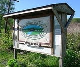
Bowerston, Ohio
Encyclopedia

Ohio
Ohio is a Midwestern state in the United States. The 34th largest state by area in the U.S.,it is the 7th‑most populous with over 11.5 million residents, containing several major American cities and seven metropolitan areas with populations of 500,000 or more.The state's capital is Columbus...
, United States
United States
The United States of America is a federal constitutional republic comprising fifty states and a federal district...
. The population was 414 at the 2000 census.
History
The village of Bowerston was settled in the early 19th century by Barnhard Bower and his brother John. When they first moved to the area, two mills were already built on the south side of Conotton CreekConotton Creek
Conotton Creek is a tributary of the Tuscarawas River, 38.7 miles long, in eastern Ohio in the United States. Via the Tuscarawas, Muskingum and Ohio Rivers, it is part of the watershed of the Mississippi River, draining an area of 286 square miles in Carroll, Harrison and Tuscarawas County,...
. One mill was a sawmill, the other a gristmill, and in 1804, they started to rebuild the mills. In 1816, the settlement called Bower's Mills was laid out and later it was called Bowersville and finally Bowerston. Bowerston was platted by David Bower, Henry Hoover, and Nathaniel Bower on August 21, 1851 and was filed in court August 2, 1852. The village was incorporated April 2, 1883.
Geography
Bowerston is located at 40°25′37"N 81°11′15"W (40.426806, -81.187523).According to the United States Census Bureau
United States Census Bureau
The United States Census Bureau is the government agency that is responsible for the United States Census. It also gathers other national demographic and economic data...
, the village has a total area of 0.5 square miles (1.3 km²), all of it land.
Demographics
As of the censusCensus
A census is the procedure of systematically acquiring and recording information about the members of a given population. It is a regularly occurring and official count of a particular population. The term is used mostly in connection with national population and housing censuses; other common...
of 2000, there were 414 people, 145 households, and 100 families residing in the village. The population density
Population density
Population density is a measurement of population per unit area or unit volume. It is frequently applied to living organisms, and particularly to humans...
was 816.9 people per square mile (313.4/km²). There were 165 housing units at an average density of 325.6 per square mile (124.9/km²). The racial makeup of the village was 100.00% White.
There were 145 households out of which 35.2% had children under the age of 18 living with them, 53.1% were married couples
Marriage
Marriage is a social union or legal contract between people that creates kinship. It is an institution in which interpersonal relationships, usually intimate and sexual, are acknowledged in a variety of ways, depending on the culture or subculture in which it is found...
living together, 12.4% had a female householder with no husband present, and 31.0% were non-families. 27.6% of all households were made up of individuals and 11.7% had someone living alone who was 65 years of age or older. The average household size was 2.50 and the average family size was 3.06.
In the village the population was spread out with 24.2% under the age of 18, 9.2% from 18 to 24, 23.9% from 25 to 44, 19.8% from 45 to 64, and 22.9% who were 65 years of age or older. The median age was 39 years. For every 100 females there were 84.8 males. For every 100 females age 18 and over, there were 80.5 males.
The median income for a household in the village was $35,000, and the median income for a family was $42,083. Males had a median income of $28,036 versus $16,932 for females. The per capita income
Per capita income
Per capita income or income per person is a measure of mean income within an economic aggregate, such as a country or city. It is calculated by taking a measure of all sources of income in the aggregate and dividing it by the total population...
for the village was $15,267. About 1.9% of families and 6.5% of the population were below the poverty line, including 5.3% of those under age 18 and 12.2% of those age 65 or over.
Education
Public education in the village of Bowerston is provided by the Conotton Valley Union Local School DistrictConotton Valley Union Local School District
The Conotton Valley Union Local School District is a public school district based in Sherrodsville, Ohio, United States.The school district is serves northwestern Harrison County and southwestern Carroll County .Three incorporated...
. Campuses serving the village include Bowerston Elementary School (Grades K-6) and Conotton Valley High School
Conotton Valley High School
Conotton Valley High School is a public high school in Bowerston, Ohio, United States. It is the only high school in the Conotton Valley Union Local School District. Their nickname is the Rockets. The Rockets are members of the Ohio Valley Athletic Conference and the Inter Valley...
http://www.conottonvalley.k12.oh.us/CV_Schools/CVHS.htm (Grades 7-12).
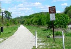
Conotton Creek Trail
Rail trail
A rail trail is the conversion of a disused railway easement into a multi-use path, typically for walking, cycling and sometimes horse riding. The characteristics of former tracks—flat, long, frequently running through historical areas—are appealing for various development. The term sometimes also...
path, the Conotton Creek Trail
Conotton Creek Trail
The Conotton Creek Trail is a rail trail in Ohio.It runs near Conotton Creek for from Bowerston to Jewett in northern Harrison County.The paved multi-use trail is suitable for biking, unicycling, roller-blading, wheel chairing, jogging and walking...
, along Conotton Creek
Conotton Creek
Conotton Creek is a tributary of the Tuscarawas River, 38.7 miles long, in eastern Ohio in the United States. Via the Tuscarawas, Muskingum and Ohio Rivers, it is part of the watershed of the Mississippi River, draining an area of 286 square miles in Carroll, Harrison and Tuscarawas County,...
. The trail is 11.4 miles (18.3 kilometers) long. It starts at the eastern end of Bowerston, at the southeast end of Erie Street. It is paved and suitable for bicycling, roller blading, wheel chairing and walking.