
Bonita Beach Causeway
Encyclopedia
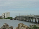
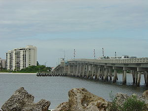
The Bonita Beach Causeway is a series of four low-level bridges located in Southwest Florida
connecting Bonita Springs
with Fort Myers Beach
. It carries Estero Boulevard (County Road 865) and is four miles long from end to end. The Bonita Beach Causeway traverses three natural barrier islands bordered by the Gulf of Mexico
and Estero Bay
. This differs from the Sanibel Causeway
(also located in Southwest Florida), which traverses man-made islands in the San Carlos Bay. Each bridge on the Bonita Beach Causeway is named after the body of water it crosses.
 Estero Boulevard (which crosses the causeway
) begins just south of the Bonita Beach Causeway in Bonita Springs. It splits off from Hickory Boulevard (County Road 865), heads north and crosses Big Hickory Pass Bridge, which lands on Big Hickory Island. After a short distance, it then crosses the New Pass Bridge, and lands on Long Key, and enters the Lovers Key / Carl E. Johnson State Park
. After crossing the Little Carlos Pass Bridge onto Black Key, Estero Boulevard turns west, leaves the Lovers Key / Carl E. Johnson State Park, and crosses the Big Carlos Pass Bridge, a small single-leaf drawbridge
, onto Estero Island
, and the town of Fort Myers Beach.
Even though the Bonita Beach Causeway travels through the Lovers Key / Carl E. Johnson State Park, it does not traverse Lover's Key itself. Lover's Key is actually just west of the causeway, and runs beside Black Key and Long Key.
Before its construction, the only way to access Estero Island and Fort Myers Beach by car was via the Matanzas Pass Bridge
(which was still a small swing bridge
at this time). The swing bridge's machinery was highly unreliable, which concerned islanders who feared the bridge would break down in the event of an emergency, such as a hurricane evacuation. The islanders felt having a second exit for the island for safety reasons would be wise. Construction on the causeway began in 1963, and the causeway opened on July 4, 1965. The Matanzas Pass Swing Bridge was replaced by the current 65 feet (19.8 m) bridge in 1979.
Southwest Florida
Southwest Florida is a region of Florida , United States located along its gulf coast, south of the Tampa Bay area, west of Lake Okeechobee and mostly north of the Everglades...
connecting Bonita Springs
Bonita Springs, Florida
Bonita Springs is a city in Lee County, Florida, United States. The population was 43,914 at the 2010 census. It is part of the Cape Coral–Fort Myers Metropolitan Statistical Area. The city is located on the southwest coast of the state....
with Fort Myers Beach
Fort Myers Beach, Florida
Fort Myers Beach is a town located on Estero Island in Lee County, Florida, United States. The population was 6,561 at the 2000 census. It is part of the Cape Coral–Fort Myers Metropolitan Statistical Area.-Geography:...
. It carries Estero Boulevard (County Road 865) and is four miles long from end to end. The Bonita Beach Causeway traverses three natural barrier islands bordered by the Gulf of Mexico
Gulf of Mexico
The Gulf of Mexico is a partially landlocked ocean basin largely surrounded by the North American continent and the island of Cuba. It is bounded on the northeast, north and northwest by the Gulf Coast of the United States, on the southwest and south by Mexico, and on the southeast by Cuba. In...
and Estero Bay
Estero Bay (Florida)
Estero Bay, Florida, is an estuary located on the west coast of the state southeast of Fort Myers Beach. The bay, an inlet of the Gulf of Mexico, is long and very shallow, and covers about . Estero Bay is bordered on the west by a chain of barrier islands: Estero Island, Long Key, Lovers Key,...
. This differs from the Sanibel Causeway
Sanibel Causeway
The Sanibel Causeway is a causeway in Southwest Florida that spans the San Carlos Bay, connecting Sanibel Island with the Florida mainland in South Fort Myers. The causeway consists of three separate two-lane bridge spans, and two man-made causeway islands, which are located between each of the...
(also located in Southwest Florida), which traverses man-made islands in the San Carlos Bay. Each bridge on the Bonita Beach Causeway is named after the body of water it crosses.
Causeway
In modern usage, a causeway is a road or railway elevated, usually across a broad body of water or wetland.- Etymology :When first used, the word appeared in a form such as “causey way” making clear its derivation from the earlier form “causey”. This word seems to have come from the same source by...
) begins just south of the Bonita Beach Causeway in Bonita Springs. It splits off from Hickory Boulevard (County Road 865), heads north and crosses Big Hickory Pass Bridge, which lands on Big Hickory Island. After a short distance, it then crosses the New Pass Bridge, and lands on Long Key, and enters the Lovers Key / Carl E. Johnson State Park
Lovers Key / Carl E. Johnson State Park
Lovers Key / Carl E. Johnson State Park is a Florida State Park located on Lover's Key and three other barrier islands—Black Island, Inner and Long Key. It is at 8700 Estero Blvd., Fort Myers Beach, between Big Carlos Pass and New Pass and west of Interstate 75 on exit 116. The park lies within...
. After crossing the Little Carlos Pass Bridge onto Black Key, Estero Boulevard turns west, leaves the Lovers Key / Carl E. Johnson State Park, and crosses the Big Carlos Pass Bridge, a small single-leaf drawbridge
Bascule bridge
A bascule bridge is a moveable bridge with a counterweight that continuously balances the span, or "leaf," throughout the entire upward swing in providing clearance for boat traffic....
, onto Estero Island
Estero Island
Estero Island is an island located in Lee County, Florida, on the Gulf coast of Southwest Florida. It is bordered by San Carlos Island to the north and Big Carlos Pass to the south. The Matanzas Pass Bridge is on the northern end of the island and connects Estero Island over Matazanas Pass to San...
, and the town of Fort Myers Beach.
Even though the Bonita Beach Causeway travels through the Lovers Key / Carl E. Johnson State Park, it does not traverse Lover's Key itself. Lover's Key is actually just west of the causeway, and runs beside Black Key and Long Key.
Before its construction, the only way to access Estero Island and Fort Myers Beach by car was via the Matanzas Pass Bridge
Matanzas Pass Bridge
The Matanzas Pass Bridge is a bridge located in Fort Myers Beach, Florida. It carries State Road 865 between the Florida mainland and Estero Island, which is a major tourist destination. The bridge is one of the island's two connections to the mainland...
(which was still a small swing bridge
Swing bridge
A swing bridge is a movable bridge that has as its primary structural support a vertical locating pin and support ring, usually at or near to its centre of gravity, about which the turning span can then pivot horizontally as shown in the animated illustration to the right...
at this time). The swing bridge's machinery was highly unreliable, which concerned islanders who feared the bridge would break down in the event of an emergency, such as a hurricane evacuation. The islanders felt having a second exit for the island for safety reasons would be wise. Construction on the causeway began in 1963, and the causeway opened on July 4, 1965. The Matanzas Pass Swing Bridge was replaced by the current 65 feet (19.8 m) bridge in 1979.