

Blufflands State Trail
Encyclopedia
Rail trail
A rail trail is the conversion of a disused railway easement into a multi-use path, typically for walking, cycling and sometimes horse riding. The characteristics of former tracks—flat, long, frequently running through historical areas—are appealing for various development. The term sometimes also...
system in southeast Minnesota
Minnesota
Minnesota is a U.S. state located in the Midwestern United States. The twelfth largest state of the U.S., it is the twenty-first most populous, with 5.3 million residents. Minnesota was carved out of the eastern half of the Minnesota Territory and admitted to the Union as the thirty-second state...
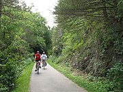
. The trail system consists of two main segments, the Root River segment, and Harmony-Preston Valley segment. The trails are used mainly for bicycling, hiking, and inline skating in the summer, and for cross country skiing in the winter. Much of the trail, especially the Root River segment, is built along a former Milwaukee Road (Chicago, Milwaukee, St. Paul and Pacific Railroad
Chicago, Milwaukee, St. Paul and Pacific Railroad
The Milwaukee Road, officially the Chicago, Milwaukee, St. Paul and Pacific Railroad , was a Class I railroad that operated in the Midwest and Northwest of the United States from 1847 until its merger into the Soo Line Railroad on January 1, 1986. The company went through several official names...
) railbed following the contours of the Root River
Root River (Minnesota)
The Root River flows for through the Driftless Area of southeastern Minnesota and is a tributary of the Upper Mississippi River. It is an excellent river for canoeing...
valley.
The degrading quality of the trail's pavement has generated concern from both trail users and local business owners. The trail was originally paved in the 1980s, and asphalt trails are typically expected to last 15 to 20 years. As of 2008, some sections of the trail still feature the original 23-year-old asphalt. There have been reports of several injuries to cyclists caused by potholes in the pavement. The DNR has expressed sympathy, but places a higher priority on repairing closed trails than on repaving open trails. In August 2007, some parts of the trail were washed out by torrential rain. The damaged areas were temporarily repaired with gravel fill, and were repaved by June 2008.
Root River segment
42.3 miles (68.1 km) in length, the trail runs predominantly east/west, following the meanders of the Root RiverRoot River (Minnesota)
The Root River flows for through the Driftless Area of southeastern Minnesota and is a tributary of the Upper Mississippi River. It is an excellent river for canoeing...
for much of the distance. Because most of this trail segment was constructed on an abandoned rail grade, most of the inclines and curves are quite gradual.
The trail intersects six towns along the way: - Fountain, Minnesota
Fountain, Minnesota
Fountain is a city in Fillmore County, Minnesota, United States. The population was 410 at the 2010 census. Fountain is the western terminus of the Root River segment of the Blufflands State Trail.-Geography:...
(western terminus of trail segment) - junction with Harmony-Preston Valley segment - Lanesboro, Minnesota
Lanesboro, Minnesota
Lanesboro is a city in Fillmore County, Minnesota, United States. The population was 754 at the 2010 census.The town is a popular destination for tourists. The Root River flows through it, with a waterfall on the edge of town. The Root River State Trail and other bike paths also serve the town...
- Whalan, Minnesota
Whalan, Minnesota
Whalan is a city in Fillmore County, Minnesota, United States. The population was 63 at the 2010 census.-Geography:According to the United States Census Bureau, the city has a total area of , of which, of it is land and of it is water....
- Peterson, Minnesota
Peterson, Minnesota
Peterson is a city in Fillmore County, Minnesota, United States. The population was 199 at the 2010 census.-Geography:According to the United States Census Bureau, the city has a total area of , of which, of it is land and of it is water....
- Rushford, Minnesota
Rushford, Minnesota
As of the census of 2000, there are 1,696 people, 704 households, and 433 families residing in the city. The population density is 988.5 people per square mile . There are 761 housing units at an average density of 443.6 per square mile...
- Houston, Minnesota
Houston, Minnesota
Houston is a city in Houston County, Minnesota, United States. The population was 979 at the 2010 census.-History:The community was named after Sam Houston, first president of the Republic of Texas....
(eastern terminus of trail segment)
Harmony-Preston Valley segment
17.8 miles (28.6 km) miles in length, the trail runs predominantly north/south. The trail follows the Root River only from the junction to Preston. South of Preston, the trail is no longer built on a former rail grade, causing the inclines to be steeper in areas. Nearing Harmony, the trail begins to form sharp right angles as it cuts between existing farm fields and properties.This segment of the trail intersects two towns: - junction with Root River segment (northern terminus of trail segment) - Preston, Minnesota
Preston, Minnesota
Preston is a city in Fillmore County, Minnesota, United States. The population was 1,325 at the 2010 census. It is the county seat of Fillmore County. The Root River runs through it, and Mystery Cave State Park is nearby...
- Harmony, Minnesota
Harmony, Minnesota
Harmony is a city in Fillmore County, Minnesota, United States. The population was 1,020 at the 2010 census. The town bills itself as the "Biggest Little Town in Southern Minnesota" and features the largest Amish community in the state.-Geography:...
(southern terminus of trail segment)