

Blue Hawk Mine
Encyclopedia
Okanagan Lake
Okanagan Lake is a large, deep lake in the Okanagan Valley of British Columbia. The lake is 135 km long, between 4 and 5 km wide, and has a surface area of 351 km². The lake's maximum depth is 232 meters near Grant Island...
. The mine is just a few kilometres from Downtown Kelowna
Kelowna
Kelowna is a city on Okanagan Lake in the Okanagan Valley, in the southern interior of British Columbia, Canada. Its name derives from a Okanagan language term for "grizzly bear"...
in the Canadian province
Provinces and territories of Canada
The provinces and territories of Canada combine to make up the world's second-largest country by area. There are ten provinces and three territories...
of British Columbia
British Columbia
British Columbia is the westernmost of Canada's provinces and is known for its natural beauty, as reflected in its Latin motto, Splendor sine occasu . Its name was chosen by Queen Victoria in 1858...
.
The mine
Mining
Mining is the extraction of valuable minerals or other geological materials from the earth, from an ore body, vein or seam. The term also includes the removal of soil. Materials recovered by mining include base metals, precious metals, iron, uranium, coal, diamonds, limestone, oil shale, rock...
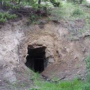
consists of several adit
Adit
An adit is an entrance to an underground mine which is horizontal or nearly horizontal, by which the mine can be entered, drained of water, and ventilated.-Construction:...
s operated for a single year, 1934, and has been virtually abandoned ever since. British Columbia's Ministry of Energy, Mines and Petroleum Resources refers to the mine as "082ENW002", and states that 5 metric tonnes of ore
Ore
An ore is a type of rock that contains minerals with important elements including metals. The ores are extracted through mining; these are then refined to extract the valuable element....
was mined yielding 560 grams (18 oz t) of silver
Silver
Silver is a metallic chemical element with the chemical symbol Ag and atomic number 47. A soft, white, lustrous transition metal, it has the highest electrical conductivity of any element and the highest thermal conductivity of any metal...
and 156 grams (5 oz t) of gold
Gold
Gold is a chemical element with the symbol Au and an atomic number of 79. Gold is a dense, soft, shiny, malleable and ductile metal. Pure gold has a bright yellow color and luster traditionally considered attractive, which it maintains without oxidizing in air or water. Chemically, gold is a...
. The total horizontal length of the mine is approximately 90 metres.
The mine is known to many Kelowna locals, and a gravel road leading past the mine is regularly maintained. The entrance to the mine often contains pooled water, but the interior is relatively dry and contains many undisturbed geological formations (first, second).
The location of the mine according to British Columbia's Ministry of Energy, Mines and Petroleum Resources is
49°59′2"N 119°31′6"W. Several Kelowna locals have reported the entrance to the mine to be at the alternate coordinates of
49°59′2"N 119°30′59"W, at an elevation of 965 meters.
History
- 1930s: Blue Hawk Mine, surface trenching and pits
- 1965 through 1980: Dawood Mines Ltd explores the property with surface trenching, linecutting, grid preparation, soil sampling, and magnetometerMagnetometerA magnetometer is a measuring instrument used to measure the strength or direction of a magnetic field either produced in the laboratory or existing in nature...
survey. F. Marshall Smith's Assessment Report also mentions "minor scaling of the main adit walls and roof", though the exact year this was undertaken is not recorded. - 1980 through 1986: Neall Curtis Lenard completes limited prospecting, mapping and sampling programs
- 1986 through ?: Pinewood Resources performs additional drilling, trenching, soil sampling for gold, and completes "a 5 hole drill program in the area of the existing adit"
More recent history of the property and rights is unclear, though the most recent owner to the property seems to be Armac Investments Ltd. of Vancouver, BC. The claims to an area covering 3 km² -- including the Blue Hawk Mine -- may have been sold by Armac to Southern Pacific Development Corp. of Vancouver, BC, in 2004 or 2005.