
Birrego, New South Wales
Encyclopedia
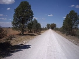
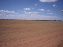
Birrego is a rural locality in the central part of the Riverina
near Boree Creek
. The countryside is flat and used predominantly for grain production. It is situated by road, about 13 kilometres south from Sandigo
and 31 kilometres south east from Morundah
.
Birrego Post Office opened on 27 September 1921 and closed in 1959.
Riverina
The Riverina is an agricultural region of south-western New South Wales , Australia. The Riverina is distinguished from other Australian regions by the combination of flat plains, warm to hot climate and an ample supply of water for irrigation. This combination has allowed the Riverina to develop...
near Boree Creek
Boree Creek, New South Wales
Boree Creek is a town in the Riverina district of New South Wales, Australia. The town is located south west of the state capital, Sydney and west of the regional centre, Wagga Wagga. Boree Creek is situated in the Urana Shire Local Government Area but is closer to the town of Lockhart...
. The countryside is flat and used predominantly for grain production. It is situated by road, about 13 kilometres south from Sandigo
Sandigo, New South Wales
Sandigo is a locality situated on Sandy Creek in the central part of the Riverina. It is situated along the Sturt Highway, about 11 kilometres north west from Kywong and 21 kilometres south east from Narrandera. At the 2006 census, Sandigo had a population of 171 people....
and 31 kilometres south east from Morundah
Morundah, New South Wales
Morundah is a small town in the Riverina region of New South Wales, Australia. The town is located on the Newell Highway and in the Urana Shire Local Government Area. The town consists of a hotel, some silos and a few houses....
.
Birrego Post Office opened on 27 September 1921 and closed in 1959.