

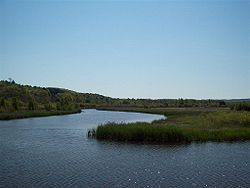
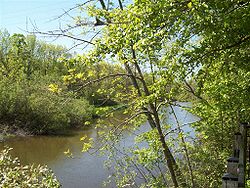
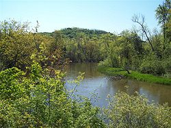
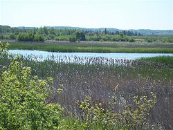
Betsie River
Encyclopedia
U.S. state
A U.S. state is any one of the 50 federated states of the United States of America that share sovereignty with the federal government. Because of this shared sovereignty, an American is a citizen both of the federal entity and of his or her state of domicile. Four states use the official title of...
of Michigan
Michigan
Michigan is a U.S. state located in the Great Lakes Region of the United States of America. The name Michigan is the French form of the Ojibwa word mishigamaa, meaning "large water" or "large lake"....
. The name is derived from the French
French language
French is a Romance language spoken as a first language in France, the Romandy region in Switzerland, Wallonia and Brussels in Belgium, Monaco, the regions of Quebec and Acadia in Canada, and by various communities elsewhere. Second-language speakers of French are distributed throughout many parts...
Riviere Aux Bec Scies, meaning river of sawbill ducks (bec-scie). Other alternate names include Aug-sig-o-sebe, Aux Buscies, Betsey's River, Black Robe, Gay-she-say-ing, Riviere du Pere Marquette, Sawbill Ducks, and Shelldrake Ducks. The river is mostly within Benzie County
Benzie County, Michigan
-Demographics:As of the 2000 census, there were 15,998 people, 6,500 households, and 4,595 families residing in the county. The population density was 50 people per square mile . There were 10,312 housing units at an average density of 32 per square mile...
(which takes its name from a variant pronunciation of the river), although the river rises in southwest Grand Traverse County
Grand Traverse County, Michigan
-Air service:*Grand Traverse County is served by Cherry Capital Airport, which is located near Traverse City.-Demographics:As of the census of 2000, there were 77,654 people, 30,396 households, and 20,730 families residing in the county. The population density was 167 people per square mile . ...
and flows briefly through northern Manistee County, Michigan
Manistee County, Michigan
-Demographics:As of the census of 2000, there were 24,527 people, 9,860 households, and 6,714 families residing in the county. The population density was 45 people per square mile . There were 14,272 housing units at an average density of 26 per square mile...
.
The river widens to form Betsie Lake before emptying into Lake Michigan
Lake Michigan
Lake Michigan is one of the five Great Lakes of North America and the only one located entirely within the United States. It is the second largest of the Great Lakes by volume and the third largest by surface area, after Lake Superior and Lake Huron...
at 44°37′45"N 86°14′45"W between Frankfort
Frankfort, Michigan
Frankfort is a city in Benzie County in the U.S. state of Michigan. The population was 1,513 at the 2000 census. The elevation of Frankfort is above sea level. The city is situated with Lake Michigan to the west, Lake Betsie, formed by the Betsie River before flowing into Lake Michigan, on the...
and Elberta
Elberta, Michigan
Elberta is a village in Benzie County in the U.S. state of Michigan. The population was 457 at the 2000 census. The village located in the east of Gilmore Township, on the south side of Lake Betsie, which is formed by the Betsie River before flowing into Lake Michigan. The village is on M-22 just...
. The Betsie River is a part of Michigan's Natural Rivers Program
Course
While most sources indicate the river rises as the outflow of Green Lake at 44°35′31"N 85°47′40"W in southwestern Grand Traverse County, some consider it navigable immediately south of US-31 from Tuller's Lake to Green Lake. Green Lake straddles the boundary between Grant TownshipGrant Township, Grand Traverse County, Michigan
Grant Township is a civil township of Grand Traverse County in the U.S. state of Michigan. As of the 2000 census, the township population was 947.-Geography:...
on the south and Green Lake Township
Green Lake Township, Michigan
Green Lake Township is a civil township of Grand Traverse County in the U.S. state of Michigan. The population was 5,009 at the 2000 census.-Communities:...
on the north between Karlin and Interlochen
Interlochen, Michigan
Interlochen is a town in Northwest Lower Michigan. The town is noted for the internationally renowned Interlochen Center for the Arts.-History:...
. Several nearby lakes, including Duck Lake and its tributaries, drain into Green Lake.
The river winds southwesterly from Green Lake into eastern Benzie County, and then briefly into northern Manistee County before turning northerly back into Benzie County. A dam on the river forms Homestead Pond, after which is flows mostly west and slightly north to Lake Michigan.
Drainage basin
The Betsie River drains an area of approximately 155026 acres (627.4 km²). in three counties. The drainage basin include about 93 miles (149.7 km) of linear stream, 52 miles (83.7 km) of which is part of the mainstream.Dams
- Homestead Dam 44°35′48"N 86°04′48"W was mostly removed in 1974 and currently acts as a lampreyLampreyLampreys are a family of jawless fish, whose adults are characterized by a toothed, funnel-like sucking mouth. Translated from an admixture of Latin and Greek, lamprey means stone lickers...
barrier. It impounds little water and does not impede salmon migrations. the remains of the dam are now sometimes called "Homestead Falls". The dam was a power generating facility formerly owned by Consumers EnergyConsumers EnergyConsumers Energy is a public utility that provides natural gas and electricity to more than 6 million of Michigan's 10 million residents. It serves customers in all 68 of the state’s Lower Peninsula counties. It is a division of CMS Energy. Its headquarters is in Jackson.-History:The company was...
. - Grass Lake Dam, approximately four miles downstream from Green Lake, forms an approximately 90 acres (36.4 ha) impoundment. The dam was constructed in 1951 to improve waterfowl habitat and northern pikeNorthern PikeThe northern pike , is a species of carnivorous fish of the genus Esox...
fishing. The dam was installed by the state Wildlife Division and created a 482 acres (195.1 ha) waterfowl flooding. - Thompsonville Dam was an old power dam that failed in the spring of 1989 and was subsequently removed. Prior to its removal, the dam posed a barrier to salmon migration. Salmon and trout have access to the entire mainstream of the river, even above the Grass Lake Dam
Tributaries
- Betsie Lake 44°37′42"N 86°13′47"W
- Crystal Lake Outlet 44°37′32"N 86°08′18"W
-
- Crystal Lake
- Cold Creek 44°37′47"N 86°05′46"W in BeulahBeulah, MichiganBeulah is a village in the U.S. state of Michigan and the county seat of Benzie County. The population was 363 at the 2000 census. It is located in Benzonia Township at the southeast end of Crystal Lake, about one mile north of Benzonia on U.S. Route 31...
- Cold Creek 44°37′47"N 86°05′46"W in Beulah
- Crystal Lake
- Rice Creek 44°36′19"N 86°06′51"W
- Dair Creek 44°33′05"N 86°03′15"W
- Little Betsie River 44°32′01"N 85°56′44"W
- Pickerel Creek 44°35′29"N 85°50′25"W
- Twin Lake 44°34′19"N 85°49′46"W
- Upper Twin Lake 44°34′19"N 85°49′17"W
- Grass Lake 44°36′30"N 85°51′03"W
- Mud Lake 44°34′31"N 85°47′55"W
- Green Lake 44°36′41"N 85°47′03"W
-
- Bridge Lake 44°38′21"N 85°47′07"W
- Tullers Lake 44°39′15"N 85°46′43"W
- Cedar Hedge Lake 44°40′12"N 85°47′04"W
- Mud Lake 44°38′36"N 85°45′28"W
- Duck Lake 44°37′53"N 85°44′42"W
- Horton Creek
- Brigham Creek 44°37′18"N 85°43′42"W
- Mason Creek 44°37′51"N 85°43′26"W
- Weidenhamer Swamp 44°37′35"N 85°36′10"W
- Tonawanda Lake 44°39′03"N 85°45′07"W
- Ellis Lake 44°39′47"N 85°44′54"W
- Saunders Lake 44°40′17"N 85°43′56"W
- Ellis Lake 44°39′47"N 85°44′54"W
External links
- Map of the Betsie River, Michigan Department of Natural ResourcesMichigan Department of Natural ResourcesThe Michigan Department of Natural Resources is the agency of the state of Michigan charged with maintaining natural resources such as state parks, state forests, and recreation areas. It is governed by a director appointed by the Governor and accepted by the Natural Resources Commission...