
.gif)
Beinn a' Chaorainn (Glen Spean)
Encyclopedia
Scotland
Scotland is a country that is part of the United Kingdom. Occupying the northern third of the island of Great Britain, it shares a border with England to the south and is bounded by the North Sea to the east, the Atlantic Ocean to the north and west, and the North Channel and Irish Sea to the...
mountain situated on the northern side of Glen Spean in the Lochaber
Lochaber
District of Lochaber 1975 to 1996Highland council area shown as one of the council areas of ScotlandLochaber is one of the 16 ward management areas of the Highland Council of Scotland and one of eight former local government districts of the two-tier Highland region...
region of the Highland
Highland (council area)
Highland is a council area in the Scottish Highlands and is the largest local government area in both Scotland and the United Kingdom as a whole. It shares borders with the council areas of Moray, Aberdeenshire, Perth and Kinross, and Argyll and Bute. Their councils, and those of Angus and...
Council area. The mountain which is located 30 km east-northeast of Fort William
Fort William, Scotland
Fort William is the second largest settlement in the highlands of Scotland and the largest town: only the city of Inverness is larger.Fort William is a major tourist centre with Glen Coe just to the south, Aonach Mòr to the north and Glenfinnan to the west, on the Road to the Isles...
is one of several of the same name in the Scottish Highlands
Scottish Highlands
The Highlands is an historic region of Scotland. The area is sometimes referred to as the "Scottish Highlands". It was culturally distinguishable from the Lowlands from the later Middle Ages into the modern period, when Lowland Scots replaced Scottish Gaelic throughout most of the Lowlands...
and should not be confused with another well known Beinn a’ Chaorainn
Beinn a' Chaorainn (Cairngorms)
Beinn a' Chaorainn is a Scottish mountain situated in the heart of the Cairngorms range. It is quite a remote hill, being located roughly 19 kilometres south east of Aviemore and 14 kilometres north west of Braemar. The mountain stands on the border of the Moray and Aberdeenshire council areas...
in the Cairngorms
Cairngorms
The Cairngorms are a mountain range in the eastern Highlands of Scotland closely associated with the mountain of the same name - Cairn Gorm.-Name:...
.
Overview
Beinn a’ Chaorainn reaches a height of 1052 metres (3451 feet) and qualifies as both a MunroMunro
A Munro is a mountain in Scotland with a height over . They are named after Sir Hugh Munro, 4th Baronet , who produced the first list of such hills, known as Munros Tables, in 1891. A Munro top is a summit over 3,000 ft which is not regarded as a separate mountain...
and a Marilyn
Marilyn (hill)
A Marilyn is a mountain or hill in the United Kingdom, Republic of Ireland or Isle of Man with a relative height of at least 150 metres , regardless of absolute height or other merit...
. It stands in a section of the Grampian Mountains often known as the Loch Laggan Hills these include the Creag Meagaidh
Creag Meagaidh
Creag Meagaidh is a mountain on the northern side of Glen Spean in Scotland. It is a complex mountain, taking the form of a flat summit plateau from which five ridges radiate, and is most famed for the cliffs surrounding the corrie of Coire Ardair on the north-eastern face...
range five km to the NE and the adjoining Munro of Beinn Teallach which is just over two km to the west. Beinn a’ Chaorainn is usually climbed in conjunction with Beinn Teallach in a 13 km horseshoe walk around the Allt a’ Chaorainn, starting at Roughburn on the A86 road
A86 road
The A86 is a major road in Scotland, United Kingdom, it runs from Spean Bridge to Kingussie. It is a primary route for all of its length.Travelling along this route carries a medium to high risk of suffering a death or serious injury accident according to EuroRAP.-References:...
. The mountains name translates from the Gaelic
Scottish Gaelic language
Scottish Gaelic is a Celtic language native to Scotland. A member of the Goidelic branch of the Celtic languages, Scottish Gaelic, like Modern Irish and Manx, developed out of Middle Irish, and thus descends ultimately from Primitive Irish....
language as “Mountain of the Rowan Tree”.
Geography
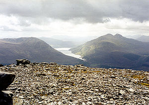
Beinn a’ Chaorainn is basically a north-south orientated ridge which looks quite an undistinguished bulk when viewed from Roughburn (see picture), the best view of the mountain being from the east where the crags of Coire na h-Uamha give the mountain some character. This corrieCirque
Cirque may refer to:* Cirque, a geological formation* Makhtesh, an erosional landform found in the Negev desert of Israel and Sinai of Egypt*Cirque , an album by Biosphere* Cirque Corporation, a company that makes touchpads...
’s name translates as the Corrie of the Cave although no significant cave is known in its environs although there are several small loch
Loch
Loch is the Irish and Scottish Gaelic word for a lake or a sea inlet. It has been anglicised as lough, although this is pronounced the same way as loch. Some lochs could also be called a firth, fjord, estuary, strait or bay...
ans within its higher recesses. It is drained by the Allt na h-Uamha whose valley separates the mountain from Creag Meagaidh massif to the east. Part of these eastern flanks of the mountain are clothed in coniferous woodland below the 550 metre contour. Coire na h-Uamha is split into two distinctive parts by an eastern ridge which gives a feasible route of ascent from the foot of the coire directly to the main summit, however some care is needed and in Winter conditions it is ranked as a Grade I Winter route.
Coire Buidhe (Yellow Coire) stands at the northern end of the mountain, this corrie is drained by the Burn of Algie, part of the headwaters of the River Roy
Glen Roy
Glen Roy in the Lochaber area of the Highlands of Scotland is a National Nature Reserve and is noted for the geological puzzle of the three roads ....
. Two routes down the ridges on either side of this corrie connects to the adjoining Munros. One route goes NW and links to Beinn Teallach at a col
Mountain pass
A mountain pass is a route through a mountain range or over a ridge. If following the lowest possible route, a pass is locally the highest point on that route...
with a height of 614 metres. The other route goes NE down to the Bealach a’ Bharnish (824 metres) before ascending onto the Creag Meagaidh plateau. The southern flank of the mountain descends to Glen Spean with more coniferous plantations below 400 metres while the western flanks are very steep as they fall to the valley of the Allt a’ Chaorainn. All drainage from the mountain finds its way to the west coast of Scotland via the River Spean, going either south directly to Glen Spean or north and going via Glen Roy before joining the Spean at Roybridge.
Summit ridge
Beinn a’ Chaorainn’s summit ridge is approximately 1.5 km in length and made up of three high points. The middle of the three tops is now regarded as the highest point, the South Top (1049 metres) was regarded as the highest point until 1974 when re-surveying downgraded it to a “Top” in the Munros Tables and elevated the middle of the pinnacles to the recognised summit. The North Top (1044 metres) is also a “Top” in the tables and has been so ever since they were first published in 1891. The summit ridge of Beinn a’ Chaorainn has the reputation as a potentially dangerous place for walkers under winter conditions with at least one fatality in 1994. The problem arises with certain sections of the eastern corrie which bite far back into the ridge and can be snow covered in winter forming cornicesCornice (climbing)
A snow cornice or simply cornice is an overhanging edge of snow on a ridge or the crest of a mountain. They form by wind blowing snow over the crest of the mountain, so they often form on the leeward sides of mountains...
. Walkers taking direct compass bearings between the high points on the summit ridge have fallen through the cornices by underestimating the distance that the corrie bites into the ridge.
Ascents
The most popular route of ascent starts at Roughburn on the A86 at grid reference , there is parking at the Loch LagganLoch Laggan
Loch Laggan is a freshwater loch situated east of Fort William, in Lochaber, Highland, Scotland. The A86 road from Spean Bridge to Kingussie follows along its north bank...
Dam, 700 metres to the SW. Forest roads and fire breaks take the walker through the forest to emerge onto the open hillside at a height of 400 metres. The route then goes NE up a broad ridge on the west side of the shallow Coire Clachaig. The view from the summit gives an excellent perspective of the Munros around Loch Treig
Loch Treig
Loch Treig is a 9 km freshwater loch situated in a steep-sided glen 20 km east of Fort William, in Lochaber, Highland, Scotland...
.