

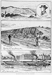
Batman's Hill
Encyclopedia
Melbourne
Melbourne is the capital and most populous city in the state of Victoria, and the second most populous city in Australia. The Melbourne City Centre is the hub of the greater metropolitan area and the Census statistical division—of which "Melbourne" is the common name. As of June 2009, the greater...
, Australia
Australia
Australia , officially the Commonwealth of Australia, is a country in the Southern Hemisphere comprising the mainland of the Australian continent, the island of Tasmania, and numerous smaller islands in the Indian and Pacific Oceans. It is the world's sixth-largest country by total area...
was named for the Vandemonian adventurer and grazier John Batman
John Batman
John Batman was an Australian grazier, businessman and explorer who is best known for his role in the founding of a settlement which became Melbourne and the colony of Victoria.-Life:...
. Now removed, the 18 metre highNoè Harsel, Masters by research: The Shepherd Kings hill was located to the south of today's Collins Street
Collins Street, Melbourne
Collins Street is a major street in the Melbourne central business district and runs approximately east to west.It is notable as Melbourne's traditional main street and best known street, is often regarded as Australia's premier street, with some of the country's finest Victorian era buildings.The...
and Southern Cross railway station
Southern Cross Station
Southern Cross is a major railway station and transport hub in Melbourne Docklands, Victoria, Australia. It is located on Spencer Street between Collins and La Trobe Streets at the western edge of the central business district...
, and is the site of a steel marker the same height as the original hill.
The hill was settled by Batman and his family, who built a house at the base in April 1836, where he lived until his death in 1839. His widow and family then moved from the house and the government requisitioned the house for government offices.
In 1837, the Hoddle Grid
Hoddle Grid
The Hoddle Grid is the layout of the streets in the centre of the central business district of Melbourne. Named after its designer, Robert Hoddle, the Grid was laid out in 1837, and later extended...
, the first town plan was designed with Batman's Hill as its western boundary.
The hill had many other uses, in February 1839 it acted as a grandstand
Grandstand
A grandstand is a large and normally permanent structure for seating spectators, most often at a racetrack. This includes both auto racing and horse racing. The grandstand is in essence like a single section of a stadium, but differs from a stadium in that it does not wrap all or most of the way...
for Melbourne's first horse race, with the site later the site of navigation beacons, and a hospital. Around the same time, Batman's Hill was also the site of the first cricket match played in Victoria by the founders of the Melbourne Cricket Club. The western slope of Batman's Hill was sold to the government in 1847 and a powder magazine was built. At the foot of the slopes were tanning pits and melting works.
In 1853 the Victorian Government offered a concession to the Melbourne, Mount Alexander and Murray River Railway Company
Melbourne, Mount Alexander and Murray River Railway Company
The Melbourne, Mount Alexander and Murray River Railway Company was a railway company in Victoria, Australia. It was established on 8 February 1853 to build a railway from Melbourne to Echuca on the Victorian-NSW border, as well as a branch railway to Williamstown, but struggled to make any progress...
to build a railway from Melbourne to Echuca
Echuca, Victoria
Echuca is a town located on the banks of the Murray River and Campaspe river in Victoria, Australia. The Border town Moama is on the northern side of the Murray river in New South Wales. It is the administrative centre and largest settlement in the Shire of Campaspe...
, including land to the east of Batman's Hill for the terminus. In 1856 the company failed, and was taken over by the government who formed the Victorian Railways
Victorian Railways
The Victorian Railways operated railways in the Australian state of Victoria from 1859 to 1983. The first railways in Victoria were private companies, but when these companies failed or defaulted, the Victorian Railways was established to take over their operations...
to complete the works, the railway station being erected at Spencer Street in 1858. Growing traffic lead to an expansion of the freight sheds in 1863, with a contract being signed in November that year for the removal of the hill. Demolition was completed by the middle of 1866.
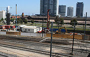
The site now forms the eastern border of the Melbourne Docklands
Melbourne Docklands
Docklands is an inner city suburb in Melbourne, Victoria, Australia occupying an area extending up to 2 km west of and adjacent to Melbourne's Central Business District . Its Local Government Area is the City of Melbourne...
(a precinct of the Docklands development is also named Batman's Hill) and is dominated by Southern Cross Station
Southern Cross Station
Southern Cross is a major railway station and transport hub in Melbourne Docklands, Victoria, Australia. It is located on Spencer Street between Collins and La Trobe Streets at the western edge of the central business district...
and the Collins Street
Collins Street, Melbourne
Collins Street is a major street in the Melbourne central business district and runs approximately east to west.It is notable as Melbourne's traditional main street and best known street, is often regarded as Australia's premier street, with some of the country's finest Victorian era buildings.The...
bridge built in 2002 to replicate the original curve and shape of the hill. The new headquarters of The Age
The Age
The Age is a daily broadsheet newspaper, which has been published in Melbourne, Australia since 1854. Owned and published by Fairfax Media, The Age primarily serves Victoria, but is also available for purchase in Tasmania, the Australian Capital Territory and border regions of South Australia and...
newspaper are located to the southern side of the bridge.
A significant portion of Batman's Hill is now being developed by the Walker Group as a commercial office precinct called Collins Square.
A 1920s hotel, the Batman's Hill Hotel was named after Batman's Hill.
Survey datum
Robert HoddleRobert Hoddle
Robert Hoddle was a surveyor of Port Phillip in the 1830s, and the creator of the Hoddle Grid, the street grid system upon which inner city Melbourne is based. He was also an accomplished artist and depicted scenes of the Port Philip region as well as New South Wales...
used Batman's Hill as the datum for the cadastral survey of the land around Melbourne from 1837.
A grid of orthogonal Section lines at one mile spacing, aligned with magnetic north, divided the land into one square mile (640 acre) sections for subdivision and land sales. The section boundaries were adjusted for watercourses. The linear property boundaries, in the absence of pre-existing tracks, were natural locations for major roads. For example:
- Swan StreetSwan Street, MelbourneSwan Street is a major street running through the Melbourne suburbs of Richmond, Cremorne and Burnley. The section of the street between Punt Road and Alexandra Avenue is now known as Olympic Boulevard....
, Riversdale RoadRiversdale Road, MelbourneRiversdale Road is a major east-west thoroughfare in Melbourne, Australia. It runs from Hawthorn to Box Hill South, and includes the many small shopping areas along it, located in Richmond, Hawthorn, Hawthorn East, Camberwell and Surrey Hills. Beyond Hawthorn, the road was originally called...
and Somerville Road are on the east-west section line that passes through the datum. - Victoria StreetVictoria Street, MelbourneVictoria Street is one of the major thoroughfares of inner Melbourne. Running east to west, Victoria Street touches the Hoddle Grid at the intersection of La Trobe Street and Spring Street, opposite the Carlton Gardens. It runs from its terminus at the intersection of Munster Terrace in North...
and Barkers Road run east-west one mile to the north - Alexandra Parade and Racecourse Road run east-west two miles to the north
- Royal Parade and Sydney RoadSydney Road, MelbourneSydney Road is a major urban arterial in the northern suburbs of Melbourne, Victoria, Australia.-Geography:...
run north-south along the section line passing through the datum. - Hoddle Street runs north-south two miles to the east
- Springvale Road runs north-south twelve miles to the east