

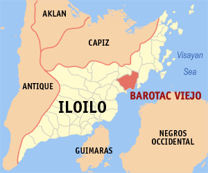
Barotac Viejo, Iloilo
Encyclopedia
Philippines
The Philippines , officially known as the Republic of the Philippines , is a country in Southeast Asia in the western Pacific Ocean. To its north across the Luzon Strait lies Taiwan. West across the South China Sea sits Vietnam...
. According to the 2007 census, it has a population of 39,326.
History
In 1957, the sitio of Poscolon in the barrio of Calaigang was converted into a barrio. Surprisingly, the same law was reenacted in 1959, probably indicating resistance to the renaming.Barangays
Barotac Viejo is politically subdivided into 26 barangayBarangay
A barangay is the smallest administrative division in the Philippines and is the native Filipino term for a village, district or ward...
s.
|
|
|
Geography
The Municipality of Barotac Viejo is found on the northern part of the Province of IloiloIloilo
Iloilo is a province of the Philippines located in the Western Visayas region. Iloilo occupies the southeast portion of Panay Island and is bordered by Antique Province to the west and Capiz Province and the Jintotolo Channel to the north. Just off Iloilo's southeast coast is Guimaras Province,...
facing the strait of Guimaras
Guimaras
Guimaras is an island province of the Philippines located in the Western Visayas region. Among the smallest provinces, its capital is Jordan. The island is located in the Panay Gulf, between the islands of Panay and Negros...
and the island of Negros
Negros
Negros is an island of the Philippines located in the Visayas, at . It is the third largest island in the country, with a land area of 13,328 km²...
. It is bounded on the north by San Rafael
San Rafael
San Rafael is a common place-name in areas where that tongue is or was spoken:-Towns, cities, municipalities, etc.:*Argentina**San Rafael, Mendoza**San Rafael Department*Bolivia...
, on the west by Banate
Banate
-Geography:* Banate, Iloilo, a municipality in the Philippines.* An alternate name for a "banovina", an internal division of the Kingdom of Yugoslavia from 1929 to 1941.* Banat, a geographical and historical region of Southeastern Europe.-See also:...
, on the south by the Visayan Sea
Visayan Sea
The Visayan Sea is a sea in the Philippines, surrounded by the islands of the Visayas, Eastern Visayas and Western Visayas located to the east and west, while the Central Visayas is located to the south...
, and on the east by Ajuy
Ajuy, Iloilo
Ajuy is a 4th class municipality in the province of Iloilo, Philippines. According to the 2007 census, it has a population of 47,113.Schools...
.
It has a latitude of 10° 59’ North and a longitude of 122° East.
The total land area of 18,578 hectares.
Topography and Land Features
A range of sprawling hills and high mountains occupies three-fourths of the land of Barotac Viejo. Mt. Opao at the center is the highest mountain, at about 550 meter high.The town is divided by a long mountain range dividing it into the upper and lower regions. The upper region is approximately 1,000 feet above sea level. The climate is generally cooler than ordinary and rain is more abundant. The lower region is compose of rice producing areas. This part is near the sea and is well populated.
Climate and Rainfall
Rainy season sets in about May and last up to the middle of January. The rainfall in the upper region is comparatively heavier than the lower region. This is due to the chain of high mountains surrounding the place and innumerable springs that flow along the foot of the hills the heaviest rainfall occurs about in the early part of September during the south monsoonMonsoon
Monsoon is traditionally defined as a seasonal reversing wind accompanied by corresponding changes in precipitation, but is now used to describe seasonal changes in atmospheric circulation and precipitation associated with the asymmetric heating of land and sea...
. Under usual condition, Barotac Viejo receives up to 100 centimeters of rainfall. The average however in the upper region is 42 centimeters and in the lower, 36 centimeters. Dry season sets in a little earlier in the lower region than in the upper region.
Water Sources
Barotac Viejo has 2 rivers, namely the Barotac Viejo River and the Barotac Cayo River. It has several creeks or springs.The Barotac Viejo River is the longest and the widest river passing through the heart of the town. It has never been dry but it sometimes overflows its banks on rainy days. The river is utilized for bathing, laundry and fishing.
The municipality has approximately 10 miles of shallow shorelines and nearby are fishponds.