

Barnegat Branch Trail
Encyclopedia
Rail trail
A rail trail is the conversion of a disused railway easement into a multi-use path, typically for walking, cycling and sometimes horse riding. The characteristics of former tracks—flat, long, frequently running through historical areas—are appealing for various development. The term sometimes also...
in New Jersey
New Jersey
New Jersey is a state in the Northeastern and Middle Atlantic regions of the United States. , its population was 8,791,894. It is bordered on the north and east by the state of New York, on the southeast and south by the Atlantic Ocean, on the west by Pennsylvania and on the southwest by Delaware...
.
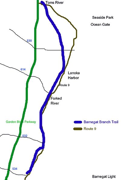
The trail occupies a 15.6 miles (25.1 km) abandoned rail corridor in Ocean County, New Jersey
Ocean County, New Jersey
-Demographics:As of the census of 2000, there were 510,916 people, 200,402 households, and 137,876 families residing in the county. The population density was 803 people per square mile . There were 248,711 housing units at an average density of 151/km²...
, that
extends from Barnegat Township
Barnegat Township, New Jersey
-History:Barnegat gets its name from nearby Barnegat Bay and Barnegat Inlet. The inlet was originally "Barendegat," or "Inlet of the Breakers," and was named by Dutch settlers in 1614 for the waterway's turbulent channel.-Demographics:...
to Toms River
Toms River, New Jersey
Toms River is a census-designated place and unincorporated area located within Toms River Township and is the county seat of Ocean County, New Jersey. It is part of a larger Toms River Township...
. The trail, is being built along the abandoned Barnegat Branch Division
Toms River Railroad
The Toms River Railroad was established in 1866 with a stop at the county seat of Toms River, New Jersey. The line was extended to Waretown in 1872 by the Toms River and Waretown RR Co. In 1881 the Central Railroad of New Jersey purchased the road and in 1893 the property was transferred to the...
of the Central Railroad of New Jersey
Central Railroad of New Jersey
The Central Railroad of New Jersey , commonly known as the Jersey Central Lines or CNJ, was a Class I railroad with origins in the 1830s, lasting until 1976 when it was absorbed into Conrail with the other bankrupt railroads of the Northeastern United States...
, which stopped service on the line in 1977.
The trail will be developed in five phases. The trail will become the ninth longest trail in the state, when completed.
- Phase I, and II of the trail are complete and connect West Bay Ave (Barnegat Twp) to Rt 532 in WaretownWaretown, New JerseyWaretown is a census-designated place and unincorporated area located within Ocean Township, in Ocean County, New Jersey. As of the United States 2000 Census, the CDP population was 1,582. Waretown is home to Albert Music Hall and 2009 Nobel Prize winner in Physics, George E...
; a length of about 3.1 miles (5 km). This is the "disconnected" southern section of the trail.
- Phase III of the trail is complete but not connected with Phases I and II. Phase III connects Cedar Creek at Dudley Park to Maryland Ave in Berkeley Tonwship; a length of about 2 miles (3.2 km).
- Phase IV of the trail project is a planned stretch of 1.5 miles (2.4 km) that would extend the phase I and II trail from Route 532 in Waretown to the LaceyLacey Township, New JerseyLacey Township is a Township in Ocean County, New Jersey and is considered part of the Jersey Shore region. As of the United States 2010 Census, the township population had increased to a record high of 27,644...
border.
- Phase V of the trail is planned and extends the phase IV trail to Osyter Creek]; a length of about 2.4 miles (3.9 km).
Controversy
A 1.9 miles (3.1 km) segment of the trail right-of-way has been the focus of an ongoing battle to build a bypass roadfor Route 9. Lacey officials are proposing a shared road-walkway for this section of the trail.