

Bad Essen
Encyclopedia
Bad Essen is a small municipality and health resort in the district of Osnabrück
, in Lower Saxony
. Bad Essen with its historical centre is located on the German Framework Road
.
, because of the transition of the low mountain range to the plains. The Wiehengebirge Range
covers approximately the southern third of the town and reaches an altitude of 211m above sea level. The highest point of the Wiehengebirge Range
is on the black Brink in Lintorf. The northern part of the town is flat, with an average altitude of 50m above sea level. The Hunte
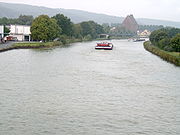
flows through the eastern part of Bad Essen northwards and crosses the Midland Canal
in Wittlage.
Osnabrück (district)
Osnabrück is a district in the southwest of Lower Saxony, Germany. With 2,121 km² it is the second largest district of Lower Saxony.- History :...
, in Lower Saxony
Lower Saxony
Lower Saxony is a German state situated in north-western Germany and is second in area and fourth in population among the sixteen states of Germany...
. Bad Essen with its historical centre is located on the German Framework Road
German Framework Road
The German Timber-Frame Road is a German tourist route leading from the river Elbe in the north to Lake Constance in the south. Along the road you can find nearly 100 cities and towns with remarkable timber-framed houses...
.
Geography
The town of Bad Essen is on the North German PlainsNorthern European Lowlands
The North European Plain is a geomorphological region in Europe. It consists of the low plains between the Central European Highlands to the south and the North Sea and the Baltic Sea to the north. These two seas are separated by the Jutland peninsula...
, because of the transition of the low mountain range to the plains. The Wiehengebirge Range
Wiehengebirge
The Wiehen Hills are a low mountain range in North Rhine-Westphalia and Lower Saxony in Germany. The hills run from west to east like a long finger away from the main upland area of the Lower Saxon Hills, beginning at the Weser River near Minden and terminating in the vicinity of Osnabrück.It is...
covers approximately the southern third of the town and reaches an altitude of 211m above sea level. The highest point of the Wiehengebirge Range
Wiehengebirge
The Wiehen Hills are a low mountain range in North Rhine-Westphalia and Lower Saxony in Germany. The hills run from west to east like a long finger away from the main upland area of the Lower Saxon Hills, beginning at the Weser River near Minden and terminating in the vicinity of Osnabrück.It is...
is on the black Brink in Lintorf. The northern part of the town is flat, with an average altitude of 50m above sea level. The Hunte
Hunte
The Hunte is a 189 km long river in north-western Germany , left tributary of the Weser. It rises in the Wiehengebirge hills. In the Northern German Plain it flows through lake Dümmer. It flows generally northwards through the towns Bad Essen, Diepholz, Wildeshausen and Oldenburg. It flows...
flows through the eastern part of Bad Essen northwards and crosses the Midland Canal
Midland Canal
The Mittelland Canal, also known as the Midland Canal, is a major canal in central Germany. It forms an important link in the waterway network of that country, providing the principal east-west inland waterway connection...
in Wittlage.