

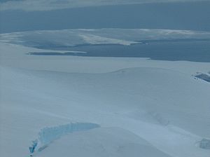
Avitohol Point
Encyclopedia
Hero Bay
Hero Bay is a 17 mi wide bay, which indents for 6 mi the north side of Livingston Island between Cape Shirreff and Williams Point, in the South Shetland Islands. The name ‘Blythe Bay’, originally applied to a small bay on the southeast side of Desolation Island on Powell's chart of 1822...
to form the west side of the entrance to Skravena Cove
Skravena Cove
Skravena Cove is a 2.1 km wide cove indenting for 1 km the north coast of Livingston Island in the South Shetland Islands, Antarctica. Entered between Avitohol Point and Kuklen Point....
and the southeast side of the entrance to Prisoe Cove
Prisoe Cove
Prisoe Cove is the 3.7 km wide cove indenting for 1.75 km the north coast of Livingston Island in the South Shetland Islands, Antarctica. Entered between Agüero Point and Avitohol Point...
. The point is named after the legendary Khan Avitohol
Avitohol
Avitohol is the first name in the Nominalia of the Bulgarian khans. Little is known about him. According to the document he is from the Dulo clan and most probably was considered and respected as the forefather of the khans....
listed in the 8th Century ‘Nominalia of the Bulgarian Khans
Nominalia of the Bulgarian khans
The Nominalia of the Bulgarian khans is a short manuscript containing the names of some early Bulgar rulers, their clans, the year of their ascending to the throne according to the cyclic Bulgar calendar and the length of their rule, including the times of joint rule and civil war...
’, who laid the foundations of the Bulgarian statehood in Europe in 165
165
Year 165 was a common year starting on Monday of the Julian calendar. At the time, it was known as the Year of the Consulship of Orfitus and Pudens...
AD.
Location
The point is located at 62°33′54"S 60°37′05"W which is 3 km northeast of Snow PeakSnow Peak (Antarctica)
Snow Peak is a snow-covered peak rising to 428 m in western Livingston Island in the South Shetland Islands, Antarctica. Linked by a saddle to Casanovas Peak in the west, and surmounting Berkovitsa Glacier to the northwest, Tundzha Glacier to the east and Verila Glacier to the southwest.The...
, 9.6 km west-southwest of Siddons Point
Siddons Point
Siddons Point is a point projecting into the middle of the head of Hero Bay on the north coast of Livingston Island in the South Shetland Islands, Antarctica...
, 10 km south-southeast of Black Point
Black Point (Antarctica)
Black Point is a rocky promontory of projecting 800 m northwards from the northeast coast of Ioannes Paulus II Peninsula into Hero Bay, Livingston Island in the South Shetland Islands, Antarctica to form the east side of the entrance to Porlier Bay...
and 14.6 km southeast of Cape Shirreff
Cape Shirreff
Cape Shirreff is a prominent cape at the north end of the rocky peninsula which separates Hero Bay and Barclay Bay on the north coast of Livingston Island, in the South Shetland Islands...
.
The point was mapped by Bulgaria in 2005 and 2009 and is registered in the SCAR Composite Antarctic Gazetteer.
Maps
- L.L. Ivanov et al. Antarctica: Livingston Island and Greenwich Island, South Shetland Islands. Scale 1:100000 topographic map. Sofia: Antarctic Place-names Commission of Bulgaria, 2005.
- L.L. Ivanov. Antarctica: Livingston Island and Greenwich, Robert, Snow and Smith Islands. Scale 1:120000 topographic map. Troyan: Manfred Wörner Foundation, 2009.
Reference
- Composite Antarctic Gazetteer: Avitohol Point.